Serampore
Serampore (also called Serampur, Srirampur, Srirampore, Shreerampur, Shreerampore, Shrirampur, Shrirampore) is a city of Hooghly district in the Indian state of West Bengal. It is the headquarter of the Srirampore subdivision. It is a part of the area covered by Kolkata Metropolitan Development Authority (KMDA).[1] It is a pre-colonial city on the west bank of the Hooghly River. It was part of Danish India under the name Frederiknagore from 1755 to 1845.
Serampore
Srirampore Sreerampur | |
|---|---|
City | |
 | |
| Nickname(s): Frederiknagore (1755 to 1845) | |
 Serampore Location in West Bengal, India  Serampore Serampore (India) | |
| Coordinates: 22.75°N 88.34°E | |
| Country | |
| State | West Bengal |
| District | Hooghly |
| Region | Greater Kolkata |
| Government | |
| • Type | Municipality |
| • Body | Serampore Municipality |
| • Chair Person | Amiya Mukherjee (AITC) |
| • MP | Kalyan Banerjee (AITC) |
| • MLA | Dr. Sudipta Roy (AITC) and Abdul Mannan (INC) |
| Area | |
| • Total | 11.60 km2 (4.48 sq mi) |
| Elevation | 17 m (56 ft) |
| Population (2011) | |
| • Total | 181,842 |
| • Density | 16,000/km2 (41,000/sq mi) |
| Languages | |
| • Official | Bengali, English |
| Time zone | UTC+5:30 (IST) |
| PIN | 712201 to 7122** |
| Telephone code | +91 33 |
| Vehicle registration | WB 15, WB 16, WB 17, WB 18 |
| Sex ratio | 941 females/1000 males ♂/♀ |
| Literacy Rate | 88.73% |
| Lok Sabha constituency | Srerampur |
| Vidhan Sabha constituency | Sreerampur and Champdani |
| Website | www |
Etymology
It is probable that the name 'Srirampur' originated either from 'Sripur', 'Sri Ram' or both, or it could originate from 'Seetarampore' as there was a very famous 'Ram-Seeta' temple. Serampore City was grown up joining by Mahesh, Ballavpur, Akna, Sripur, Gopinathpur, Manoharpur, Chatra, Rajyadharapur, Naoga, Sheoraphuli, Shimla - Sataghara villages. Here some aristocratic localities came up, namely Goswamipara, Lahiripara, Mukherjeepara, Bhattacharyapara, Chakravartipara, Beniapara, etc., whose inhabitants were Brahmins of different groups and sects.
History
The city is several centuries old and has witnessed both the growth and decline of the feudal system, the coming of the Danes and their settlement and then a cultural renaissance (known as the Bengal Renaissance) initiated by the British following the construction of the east Indian railway, along with subsequent industrial development.
There were three main phases in the process of urbanisation of Serampore:
- The Pre-urbanisation phase (the period before 1755);
- The Urbanisation phase (from 1755 to 1854); and
- The Industrialisation phase (1854 to 1947).
Before the Mughal era, the region between the Saraswati and Hooghly rivers was a thriving local community.
After this, there arose the need for local artisans along with "service class" people who came from the neighbouring villages and settled on granted land. In this way, colonies such as Patuapara, Kumarpara, Dhulipara, Goalpara, Dutta Bagan, Khash Bagan were formed. This along with the fact that Sheoraphuli was a distribution point for local marketable goods produced in different parts of Hughli, induced many families - the Barujibis, Duttas, Deys, Das, etc. - to come to settle here before 1755.
The cultivating classes settled in such places as Sadgoppara, Mannapara, Lankabaganpara. The Jele-Kaibarta and 'Sani' Muchi, were already in the locality from the beginning, and had their own areas. The local Sunni Muslims, descendants of Mughal soldiers, traders, and artisans, lived in Mullickpara, Mussalman Para and here a mosque still bears witness to their existence.
During the Mughal period, Akna (today's Akra Bati Lane) and Mahesh were heavily populated. The hot humid climate of the area suited the textile industry and the local land was well known for its cotton and silk weaving. The Hindu weavers used to manufacture fine cotton pieces, while the Muslim weavers monopolised silk manufacture. In the fertile land, paddy, jute and betel-leaf were grown in abundance. The Kaibarta used the marshy land for fishing.
In pre-urbanisation age, communication was mainly by way of the river. Besides this, there was the 'Badshahi Sadak' or the grand trunk road. Before Danes arrived in this region, the Sheoraphuli Hat was the main internal trade centre and had close commercial links with Barisal, Khulna, Dhaka, Mymensingh, Rajshahi and other districts of East Bengal (now Bangladesh).
Between the 14th and 18th centuries, many foreign merchants, such as the French, Portuguese and Dutch - established their trading outposts, or "Kuthis", here and were involved in trade and commerce.
During the Muslim period, the villagers on the bank of the Hooghly and Saraswati were included in the zamindaries of Sheoraphuli; these feudal lords not only collected rent but also dispensed justice.
Danish rule
The urbanization phase began with the acquisition of land in the area by the Danes in the early 18th century, as part of the Danish colonial empire. In 1755, the Danish East India Company sent a representative from its Tranquebar office to the Nawab of Bengal. Their intention was to secure a parwana (district jurisdiction) allowing them the right to do business in Bengal. They obtained the parwana by paying fifty thousand rupees in cash to Nawab Alivardi Khan, along with many gifts, acquiring three bighas of land at Sripur on the riverfront and then another fifty-seven bighas at Akna for the building of a new factory and port, which the Danes governed from Tranquebar. Subsequently, the Danes acquired the Serampore, Akna and Pearapur mahals by paying an annual rent of 1601 rupees to the zamindar (tax farmer) of Sheoraphuli in North Serampore. By 1770 the Danish merchants were beginning to make significant progress in trade and commerce in the area. Danish prosperity was assisted by the able administrative performance of Colonel Ole Bie, who was appointed the first Crown regent of Serampore in 1776.
The Danes also established a bazaar (the present Tin Bazaar) and allowed private godowns, or warehouses to be maintained. Gradually, the town developed and became elegant and prosperous, and merchants of both foreign and indigenous origin began to arrive and live there.
Initially the Danes were dependent on their factors for obtaining commodities (primarily silk and cotton fabrics), but they later got involved in collection of merchandise directly from the producers, and offered incentives to the artisans in the form of earnest money for making high-quality products. They also created a class of trading middlemen, such as agents, banias, mutsuddis, and stevedores.
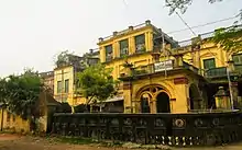
Sobharan Basak and Anandaram Dhoba, the two local textile businessmen, were appointed as the first 'factors' for the Danes. Nandalal Chakravarty was their first agent, and subsequently, he was promoted to "Dewan". Patita Paban Roy, who came from Katulpur in Bankura, and Saphali Ram Dey were appointed agents for the supplying of saltpetre. Brothers Raghuram Goswami and Raghavram Goswami came to Serampore from their home village of Patuli, to seek their fortune. Raghuram secured a job at the commissariat of the Danish Governor, while Raghavram became the official moneylender to the factory. Between them, they amassed a huge fortune acquired vast lands and founded an aristocratic colony on the western side of Serampore with their family. Their descendants still live in Serampore today.
As a sop to the weavers of Akna and Mohanpur villages, the Danes gave advances for both cotton and fine silk products. The merchants also established their own factory to produce fine cloths. They collected 'Hammer' and 'Luckline' ropes for ships, various other kinds of ropes and agricultural produce. They inspired the cultivators of Pearapur to cultivate indigo in addition to paddy rice. Mr. Princep was their indigo agent.
Another notable source of their income was the Hoondi business. Colonel Ole Bie was also interested in making Serampore a charming, elegant, attractive tourist resort. It became a well-protected town and the maintenance of law and order was well developed. To facilitate municipal administrative and judicial work, a new Court House was built and a metalled road was laid on the river bank and magnificent palatial buildings were erected.
The local civil administration, however, was carried out by a prototype of a municipality known as the 'Village Committee', with Ole Bie as its Governor. The balmy days of Danish overseas trade largely coincided with the service of Ole Bie as Head of the factory, serving from 1776 to 1805, with only a few interruptions.
Marshman and Carey
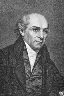
The beginning of the 19th century can be considered the most significant period in the history of Serampore, with the arrival of four English missionaries - Joshua Marshman, Hannah Marshman, William Carey, and Willam Ward - who between them were the architects of the Serampore renaissance. Although they came chiefly for the purpose of preaching Christianity, they dedicated themselves to the service of ailing and distressed people in and around the town, spreading education, social reforms, and social reconstruction.
They established more than a hundred 'monitorial' schools in the region. Hannah Marshman established the first Girls' School at Serampore, which received much public approval. Carey made an outstanding contribution by founding the Serampore Mission Press in 1800 where the wooden Bengali types made by Panchanan Karmakar were installed.
Perhaps the crowning work of Carey and his two associates was the establishment of the Serampore College in 1818 which acts both as a university through the Senate of Serampore College (University) and as an individual college. The founders had to spend their last farthing on the construction of its magnificent buildings. It was also the first college in Asia to award a degree.
Carey became famous as the father of Bengali prose. The Mission Press published three books - the Bengali translation of the Bible, Hitopadesh and Kathopakathan. Munshi Ramram Basu, the pundit appointed by Carey, brought out Pratapaditya Charita (1802) as well as Kashidas' Mahabharat (1802) and Krittibas' Ramayan (1803). The first issue of the second Bengali daily, Samachar Darpan came out in 1818 under the editorship of Carey.
At the same time, the Serampore Mission Press brought out the English daily, A Friend of India (precursor to The Statesman). Another outstanding contribution of the missionaries was the installation of India's first paper mill, at Battala, set up by John Clark Marshman (the son of Joshua and Hannah Marshman) which was powered by a steam engine.
Between 1801 and 1832 the Serampore Mission Press printed 212,000 copies of books in 40 different languages. In this cultural development, the local inhabitants had only a passive role. Only a few among the affluent, comprising absentee landlords and businessmen, seized the opportunity for higher education by sending their children to the academic institutions of the missionaries. On the other hand, people belonging to the lower economic stratum sent their children to the monitorial schools, which provided basic education. In the process, there emerged a class of local gentry, who had a favourable attitude towards the missionaries.
British rule
Serampore was turned into a sub-division in the District of Hooghly in 1845. Serampore Municipality was set up separately in 1865. Serampore and its adjoining areas were famous for learning. The Sanskrit Schools are popularly known as 'Tole' were engaged in the teaching of Sanskrit and published journals like 'Gyanarunodaya' (1852), 'Satya Pradip', 'The Evangelist' (1843), 'Arunodaya' (1856), 'Sarbartha-Sangraha' (1873), 'Aakhbare Serampore' (1826), 'Bibidha Barta Prakasika' (1875), 'Prakiti Ranjan' (1878) and 'Benga-Bandhu' (1882). Literature was always shining in Serampore. Rev. Lal Behari Dey, M. Tansdend, Narayan Chattaraj Gunanidhi, Kalidas Maitra, John Robinson, and others were very active in their literary activities. It is said that Raja Ram Mohan Roy, the first modern man in India was born at Chatra in Serampore at his maternal uncle's house through the issue is still controversial. Dinabandhu Mitra, the great author, was posted as postmaster (Head Post Office), Serampore. Bibhutibhusan Mukhopadhyay, the famous litterateur, spent his childhood days at Chatra in Serampore. Poets such as Amiya Chakraborty, Haraprasad Mitra were also born there.
On 11 October 1845, it was sold to Britain, which integrated it into British India and officially restored the Bengali name. After taking possession of the town, the British began to look after its civic amenities and the earlier 'Village Committee' was transformed into the Serampore Municipality in 1865. Rishra and Konnagar were also included in it.
Raja Ram Mohan Roy was born in Serampore. At that time, the affluent high caste section of the Serampore population displayed no sign of modernisation, nor did they subscribe to an urban ethos. The Indian economy during the period was passing through a severe recession. There was continuous migration of rural people to the urban centres. Landless labourers from Uttar Pradesh, Andhra Pradesh, Bihar and Orissa came to Serampore in search of employment. When the second Jute Mill was opened in 1866 in Serampore (the first one was set up at Rishra in 1855) the town began to grow as an industrial town. Along with the Jute mills, many other subsidiary factories came up in the erstwhile rural areas within or on the fringes of the town.
Thus, with the capital investment of the British the commercial town of Serampore was transformed into an industrial one. The deciding force behind the process was the laying of the railway line from Howrah to Burdwan in 1854. It ushered in a great change in the social composition of the town. Between 1866 and 1915, six more jute mills were established at Rishra, Serampore and Chandannagar. The local landlords, thikadars, and mill-owners made arrangements for the habitation of the labour force around the factories. Thus at Mahesh, Akna, and Tarapukur mouzas adjacent to the Ganges, workers' colonies like Odiabasti, Gayaparabasti, Chhapra Basti and Telengi para Basti were established. Because of the arrival of these migrant workers, the population in Serampore increased from 24,440 to 44,451 between 1872 and 1901. The habitations of labourers were unhygienic, overcrowded slums. There was no provision for even the bare minimum of civic amenities in their dwellings.
In 1914, an arrangement was made to supply filtered potable water from the Municipality. The Town Hall was established in memory of Kishori Lal Goswami in 1927. At the initiative of the Government, the weaving school was founded during the thirties, and later on, it was raised to the status of a Textile College. The municipality began to provide electricity in 1938. After fifty years of British possession, Serampore was swept by the waves of a Bengali cultural and nationalist movement. The spirit of nationalism influenced many youths from middle-class families. It resulted in the decline of foreign investment in industries. But there was an increase in indigenous investment. The Bangalakshmi Cotton Mill was founded out of the swadeshi spirit. From the beginning of the 20th century, many primary schools and educational institutions were set up in Serampore. The descendants of some of the older aristocratic families donated their residential buildings for benevolent purposes.
Post 1947
Since 1947, Serampore has become a satellite of Kolkata (formerly Calcutta) and as such its process of urbanisation and change is as yet still incomplete. Now Serampore is one of the most developed (city) towns in the main line region of Howrah.
Geography
| Cities and towns in the Sreerampur Uttarpara CD Block in Srirampore subdivision in Hooghly district M: municipal city/ town, CT: census town, Owing to space constraints in the small map, the actual locations in a larger map may vary slightly |
Location
Serampore is located at 22.75°N 88.34°E.
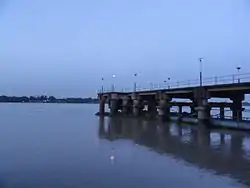
The area consists of flat alluvial plains, that form a part of the Gangetic Delta. This belt is highly industrialised.[2]
Police stations
Serampore police station has jurisdiction over Serampore and Baidyabati Municipal areas, and parts of Sreerampur Uttarpara CD Block. Serampore Women police station has been set up.[3][4]
Urbanisation
Srirampore subdivision is the most urbanized of the subdivisions in Hooghly district. 73.13% of the population in the subdivision is urban and 26.88% is rural. The subdivision has 6 municipalities and 34 census towns. The municipalities are: Dankuni Municipality, Uttarpara Kotrung Municipality, Konnagar Municipality, Rishra Municipality, Serampore Municipality and Baidyabati Municipality. Amongst the CD Blocks in the subdivision, Uttarapara Serampore (census towns shown in the map alongside) had 76% urban population, Chanditala I 42%, Chanditala II 69% and Jangipara 7% (census towns in the last 3 CD Blocks are shown in a separate map).[5][6] All places marked in the map are linked in the larger full screen map.
Climate
| Climate data for Serampore | |||||||||||||
|---|---|---|---|---|---|---|---|---|---|---|---|---|---|
| Month | Jan | Feb | Mar | Apr | May | Jun | Jul | Aug | Sep | Oct | Nov | Dec | Year |
| Average high °C (°F) | 26 (79) |
29 (84) |
33 (91) |
36 (97) |
36 (97) |
34 (93) |
33 (91) |
33 (91) |
33 (91) |
32 (90) |
30 (86) |
27 (81) |
32 (89) |
| Average low °C (°F) | 12 (54) |
16 (61) |
21 (70) |
24 (75) |
25 (77) |
26 (79) |
26 (79) |
26 (79) |
26 (79) |
24 (75) |
— | 14 (57) |
— |
| Average precipitation mm (inches) | 19.2 (0.76) |
39.4 (1.55) |
38 (1.5) |
49.5 (1.95) |
132.7 (5.22) |
245.9 (9.68) |
347.6 (13.69) |
322.4 (12.69) |
291.2 (11.46) |
163.6 (6.44) |
27.9 (1.10) |
5.7 (0.22) |
1,683.1 (66.26) |
| Source: Serampore Weather | |||||||||||||
Demographics
According to an India census, Serampore had a population of 181,842 in 2011. Males constituted 51.55% of the population and females 48.45%. It had an average literacy rate of 88.73%, higher than the national average of 74.04%: male literacy was 92.75% and female literacy 87.05%; 7% of the population was under 6 years of age.[8]
Kolkata Urban Agglomeration
The following Municipalities and Census Towns in Hooghly district were part of Kolkata Urban Agglomeration in 2011 census: Bansberia (M), Hugli-Chinsurah (M), Bara Khejuria (Out Growth), Shankhanagar (CT), Amodghata (CT), Chak Bansberia (CT), Naldanga (CT), Kodalia (CT), Kulihanda (CT), Simla (CT), Dharmapur (CT), Bhadreswar (M), Champdani (M), Chandannagar (M Corp.), Baidyabati (M), Serampore (M), Rishra (M), Rishra (CT), Bamunari (CT), Dakshin Rajyadharpur (CT), Nabagram Colony (CT), Konnagar (M), Uttarpara Kotrung (M), Raghunathpur (PS-Dankuni) (CT), Kanaipur (CT) and Keota (CT).[9]
Transport
State Highway 6/ Grand Trunk Road passes through the town and it is also close to Kolkata-Delhi Road. G.T. Road and Kolkata-Delhi Road are connected by Road number 31 (The two crossings are Nabagram More & Milki Badamtala More). G.T. Road divides the town into eastern & western parts. Every day about more than 10,000 vehicles passes through this road. Bus service is good in Serampore.
Private Bus
- 2 Chunchura Court - Dakshineswar
- 26A Serampore City Bus Terminus - Aushbati
- 31 Serampore City Bus Terminus - Jangipara
- 40 Serampore City Bus Terminus - Birshibpur
- 285 Serampore City Bus Terminus - Salt Lake Sector-5
Train
Serampore railway station serves the locality of Serampore. On 15 August 1854, India's second railway started operation between Howrah and Hooghly. The first stop on that first train was in Bally and then the second halt was in Serampore. Serampore station is a very important stoppage of the Howrah–Bardhaman main line railway. Many important Local and Passenger trains and few Express trains stop here. Serampore railway station: Daily Train UP - 136 and Down - 135.
Water
Serampore is connectee to Barrackpore and Titagarh by Ferry service on Ganges/Hooghly River. There are four Ferry service in the town (6 AM-10 PM):
- Mahesh Jagannath Ferry Ghat - Titagarh
- Ballavpur Radha-Ballav Jiu Ferry Ghat - Titagarh
- Juggal Auddy Ferry Ghat - Barrackpore
- Chatra Char Poisar Ferry Ghat - Barrackpore
Air
Kolkata Airport is 34 km from Serampore.
Architecture
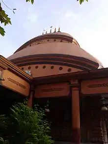
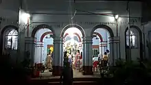
Various Temples, can be found in the Serampore area, such as:
- The temple of Radha-Ballabh at Ballavpur (18th century)
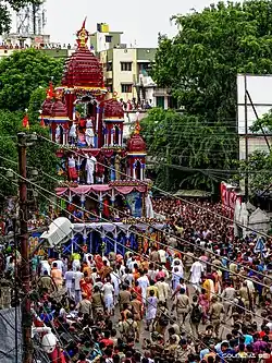
- The temple of Lord Jagannath at Mahesh (Idol-1396 A.D. & Temple- 1755 A.D.)
- The Rathayatra of Mahesh
- The Ram-Sita temple, Sripur
- Gauranga Bati at Chatra (16th century)
- Hari Sabha at Battala
- Buro Bibi Mazar at Buro bibi lane
- Chatra Alamin Siddiquea Masjid at AP Ghosh Rd
- Gausia Masjid at Arabinda Darano, Chatra
- Kameshwar Kameshwari Temple at Bhagirathi Lane, Mahesh under Ramakrishna Shibananda Ashram Trust
- Jhautala Mosque, Dharmatala
- Mullickpara Mosque, Mullickpara
- Silbagan Mosque
- Sashan Kali Mandir at Ballavpur
- Shree Charan Kamal Gurudwara Sahib at KM Shah Street
- Henry Martin's Pagoda, Ballavpur
- Sitalatala Mandir, Chatra Sitalatala
- Nistarini Kali Bari, Sheoraphuli Ghat
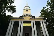
- St. Olav's Church, Tin Bazar
- Johnnagar Baptist Church, near Serampore College
- Immaculate Conception Church, MG Road
- Johnnagar Church, Mahesh
The Jagannath temple of Mahesh is dated to 1755. When Bengal came under the command of Sri Chaitanya's Vaisnavism in the 15th century, these places became pre-eminent as a Hindu pilgrim centre.
Raja Manohar Roy, Zamindar of Sheoraphuli (then North Serampore), built the temple of Ram-Sita in Sripur in 1753 and his son Ram Chandra Roy then later dedicated the villages of Sripur, Gopinathpur and Manoharpur as devottara land in the service of the deity. Subsequently, the temple was taken care of by Raja Nirmal Chandra Ghosh and the 'Seoraphuli Raj Debuttar Estate'. In present times, the temple and its premises fall under the surveillance of the ''Seoraphuli Rajbari'.
Education
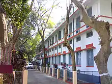
- Serampore College
- Government College of Engineering and Textile Technology
- Serampore Union Institution
- Serampore Girls' College
- Mahesh Sri Ramkrishna Ashram Vidyalaya (Higher Secondary)
- Serampore Girl's High School (Akna Girl's High School)
- Chatra Nandalal Institution
- Serampore Mission Girls High School
- Malina Lahiri Boy's Academy
- Holy Home School
- West Point Academy
- Gospel Home school
- Pearl Rosary school (Mahesh)
- Pearl Rosary school (West Chatra)
- Kidzee
- Bangla High School
- Ballavpur High School
- Mahesh high School
- Mahesh Banga Vidyalaya
- Ramesh Chandra Girl's High School
- Rajyadharpur Netaji Uchcha Balika Vidyalaya
- Parameshwari Girl's High School
- Nabagram K D Paul Vidyalaya
- Chatra Bani Balika Vidyalaya
- Anjuman.n.c.l.project School
- Aurobindo N.c.l.p School
- Bharati Balika Pry. School
- Fatema Girls Jr. High School
- Gopinath Saha Pry. School
- Mission Girls High School
- Nayabasti Sree Shiva Jr High(h
- Saraswati.n.c.l.p Special School
- Viswanath Vidyamandir
- Prabash Nagar G.s.f.p.
- Mallickpara Municipal Free Pry
See also
- Rathayatra of Mahesh
- Srerampur (Lok Sabha constituency)
- Sreerampur (Vidhan Sabha constituency)
- Serampore College
- Senate of Serampore College (University)
- Serampore Town Railway Station
- Srirampore subdivision
- Serampore Mission Press
- Hannah Marshman
- William Carey
- Joshua Marshman
- Willam Ward
- Serampore Trio
- Sheoraphuli Raj Debuttar Estate
- Sheoraphuli
- Sheoraphuli railway station
References
- "Base Map of Kolkata Metropolitan area". Kolkata Metropolitan Development Authority. Archived from the original on 28 September 2007. Retrieved 3 September 2007.
- "District Census Handbook: Hugli, Series-20, Part XIIA" (PDF). Physiography, Page 17–24. Directorate of Census Operations, West Bengal, 2011. Retrieved 28 September 2018.
- "District Statistical Handbook 2014 Hooghly". Tables 2.1, 2.2. Department of Statistics and Programme Implementation, Government of West Bengal. Retrieved 15 October 2018.
- "Hooghly District Police". West Bengal Police. Retrieved 20 June 2017.
- "District Statistical Handbook 2014 Hooghly". Table 2.2, 2.4(a). Department of Statistics and Programme Implementation, Government of West Bengal. Retrieved 3 October 2018.
- "C.D. Block Wise Primary Census Abstract Data(PCA)". 2011 census: West Bengal – District-wise CD Blocks. Registrar General and Census Commissioner, India. Retrieved 3 October 2018.
- "City Census 2011". Census2011.co.in. 2011. Retrieved 30 September 2011.
- "Census of India 2011: Serampore City Census 2011 data". Census Commission of India. Retrieved 1 November 2015.
- "Provisional Population Totals, Census of India 2011" (PDF). Constituents of Urban Agglomeration Having Population Above 1 Lakh. Census of India 2011. Retrieved 16 June 2016.
External links
| |||||||||||||||||||||
| |||||||||||||||||||||
| |||||||||||||||||||||
| |||||||||||||||||||||
| |||||||||||||||||||||
| |||||||||||||||||||||
| |||||||||||||||||||||
.svg.png.webp)
Cities, towns and locations in Hooghly district | |||||||||
|---|---|---|---|---|---|---|---|---|---|
| Cities, municipalities and census towns |
| ||||||||
| Locations other than cities and towns |
| ||||||||
| Neighbourhoods | |||||||||
| Related topics |
| ||||||||
| Kolkata Municipal Corporation |
|
|---|---|
| Kolkata Urban Agglomeration Outside KMC |
|
| |
| Authority control |
|---|