Kra Daadi district
Kra Daadi is a district in Arunachal Pradesh in north-eastern India. It was carved out of Kurung Kumey district on 7 February 2015.[1]
Kra Daadi district | |
|---|---|
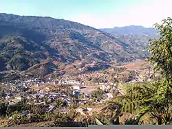 View of Palin town | |
 Location of Kra Daadi district in Arunachal Pradesh | |
| Country | |
| State | Arunachal Pradesh |
| Division | Arunachal west |
| Headquarters | Jamin |
| Government | |
| • Lok Sabha constituencies | Arunachal west |
| Area | |
| • Total | 2,202 km2 (850 sq mi) |
| Elevation | 2,060 m (6,760 ft) |
| Population (2011) | |
| • Total | 22,290 |
| • Density | 10/km2 (26/sq mi) |
| Demographics | |
| • Literacy | 44% |
| • Sex ratio | NA |
| Time zone | UTC+05:30 (IST) |
| Website | kradaadi |
History
The creation of Kra Daadi district was approved on 21 March 2013 under the Arunachal Pradesh (Re-Organization of Districts) (Amendment) Bill.[2]
Kra Daadi was inaugurated by the then Chief Minister Nabam Tuki as the 19th district of Arunachal Pradesh on 7 February 2015.[1]
Administration
Jamin, located 20 km away from Palin is the proposed headquarter of the district. It has two assembly constituencies, viz., Jamin (also called Damin), Tali, Palin, covering eight circles viz. clockwise from north, Pipsorang, Tali, Chambang, Palin, Yangte, Tarak Langdi, and Gangte.[1] It is flanked by Tibet international border with China to the north, Upper Subansiri district to the east, Lower Subansiri district to the south, Papum Pare district to the southeast, Kurung Kumey district to the west. Pania is a sub-division in the district located few miles away from Palin and is administered by an Additional Deputy Commissioner.
References
- "Arunachal Pradesh carves out new district". The Times of India. 9 February 2015.
- "Arunachal clears bill for four new districts". The Times of India. 22 March 2013.
External links
| Wikimedia Commons has media related to Kra Daadi district. |
| State symbols | |
|---|---|
| Topics |
|
| Administration |
|
| Divisions |
|
| Districts | |
| Major Towns |
|
| Historical Places | |
Portal: India | |