Kurung Kumey district
Kurung Kumey district (Pron:/kʊˈɹʌŋ kʊˈmi/) is one of the 26 districts of the northeastern Indian state of Arunachal Pradesh, with its district headquarters in Koloriang.
Kurung Kumey district | |
|---|---|
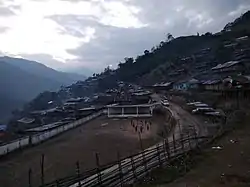 Sarli valley | |
 Location of Kurung Kumey district in Arunachal Pradesh | |
| Country | |
| State | Arunachal Pradesh |
| Headquarters | Koloriang |
| Population (2011) | |
| • Total | 92,076[1] |
| Demographics | |
| • Literacy | 50.7% |
| • Sex ratio | 1029 |
| Time zone | UTC+05:30 (IST) |
| Website | kurungkumey |
Origin of name
The name of this district is derived from the Kurung and the Kumey, the two principal rivers which flow through it. According to myth the Kurung and the Kumey rivers were two sisters; during the age of marriage Kurung eloped without prior permission from her parents and Kumey got married according to her parents' wishes. Therefore, the Kurung flows with a violent roar and ashy color because her parents shouted and threw ashes after her, while the Kumey flows silently and clearly.
History
The territory occupied by the present district became part of the North East Frontier Tracts in 1914. In 1954, it became part of Subansiri Frontier Division, which was later renamed as Lower Subansiri district. On 1 April 2001, this district was created by bifurcating Lower Subansiri district.[2]
Divisions
The following are the sub-divisions and circles of Kurung Kumey district:
- Nyapin Sub-Division: Circles of Nyapin, Phassang
- Koloriang Sub-Division: Circles of Parsi-Parlo, Koloriang, Sangram
- Damin Sub-Division: Circles of Sarli, Damin
There are two Arunachal Pradesh Legislative Assembly constituencies in this district: Nyapin, and Koloriang. Both of these are part of Arunachal West Lok Sabha constituency.[3]
Demographics
According to the 2011 census Kurung Kumey district has a population of 92,076, roughly equal to the nation of Seychelles.[4] This gives it a ranking of 617th in India (out of a total of 640). The district has a population density of 15 inhabitants per square kilometre (39/sq mi). Its population growth rate over the decade 2001–2011 was 111.01%. Kurung Kumey has a sex ratio of 1029 females for every 1000 males, and a literacy rate of 50.67%.
Hiya village under the Nyapin circle is the largest village of Kurung Kumey district in terms of total population and geographical extent. The village is inhabited by clans like Hiba, Takio, hillang, but mostly by Tame Clan. (Now known as Tarh clan). Tarh is a clan-based society mixed of several clans like Hura, Tam, Takio, Tame, Tayeng, Hina, Tarak, and many more.. some settled in Kra Daadi, some in Papum pare. There are many Societies base clans(Mixed of clans)in Kurung Kumey but Tadar a clan(not society) is the largest clan of Kurung Kumey district closely followed by Bengia, Kipa, Lokam & Tai followed by many other clans..
The main tribes inhabit the district are Nyishi, Bangru, and Puroik. Bangru as a distinct cultural and linguistic group is hardly known by outsiders; who still consider them as part of the Nyishi tribe. But according to recent researches, they are distinct from Nyishi in terms of their language and origin. They are considered to be more similar to Miji (Sajolang) of West Kameng district of Arunachal Pradesh in terms of their language and traditional customs.
References
- "District Census 2011". Census2011.co.in.
- Law, Gwillim (25 September 2011). "Districts of India". Statoids. Retrieved 11 October 2011.
- "Assembly Constituencies allocation w.r.t District and Parliamentary Constituencies". Chief Electoral Officer, Arunachal Pradesh website. Archived from the original on 13 August 2011. Retrieved 21 March 2011.
- US Directorate of Intelligence. "Country Comparison: Population". Retrieved 1 October 2011.
Seychelles 89,188 July 2011 est.
External links
- Kurung Kumey district website
- 50 pc voters exercise franchise
- Kurung Kumey 14th district in Arunachal
- PHED profile
- Health workers take the road less travelled in Arunachal
- In Arunachal records, a tribal eats 64 kg rice
Places adjacent to Kurung Kumey district | ||||||||||
|---|---|---|---|---|---|---|---|---|---|---|
| ||||||||||
| State symbols | |
|---|---|
| Topics |
|
| Administration |
|
| Divisions |
|
| Districts | |
| Major Towns |
|
| Historical Places | |
Portal: India | |