Papum Pare district
Papum Pare district (Pron:/ˌpæpəm ˈpæɹɪ or ˈpɑ:ɹeɪ/) is an administrative district in the state of Arunachal Pradesh in India. As of 2011, it is the most populous district of Arunachal Pradesh (out of 20).
Papum Pare district | |
|---|---|
District of Arunachal Pradesh | |
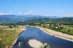 Dikrong river near Itanagar | |
 Location of Papum Pare district in Arunachal Pradesh | |
| Country | |
| State | Arunachal Pradesh |
| Headquarters | Yupia |
| Area | |
| • Total | 2,875 km2 (1,110 sq mi) |
| Population (2011) | |
| • Total | 176,573 |
| • Density | 61/km2 (160/sq mi) |
| Demographics | |
| • Literacy | 82.1% |
| • Sex ratio | 950 |
| Time zone | UTC+05:30 (IST) |
| Website | papumpare |
History
The district was formed in 1999 when it was split from Lower Subansiri district.[1]
Geography
The district headquarters are located at Yupia. Papum Pare district occupies an area of 2,875 square kilometres (1,110 sq mi).[2] The capital of the state is Itanagar,
Subdivisions
The district is divided into three subdivisions: Itanagar capital complex, Yupia, and Sagalee. The district is further divided into 15 administrative circles, namely, Balijan, Itanagar, Naharlagun, Doimukh, Toru, Sagalee, Leporiang, Mengio, Kimin, Banderdewa, Tarasso, Kakoi, Gumto, Parang, and Sangdupota.[3]
There are 3 Arunachal Pradesh Legislative Assembly constituencies located in this district: Itanagar, Doimukh and Sagalee. All of these are part of Arunachal West Lok Sabha constituency.[4]
Itanagar capital complex
Itanagar capital complex is administered by its own Deputy Commissioner,[3] and contains the three circles of Itanagar, Naharlagun, and Banderdewa.[5] In January 2013 the Arunachal Pradesh government approved in principle the creation of a "Capital district".[6] The capital complex is currently treated as its own district by some government departments, the Ministry of Micro, Small and Medium Enterprises for example,[7] and the Arunachal Pradesh State portal in particular.[8]
Demographics
| Year | Pop. | ±% p.a. |
|---|---|---|
| 1961 | 12,823 | — |
| 1971 | 17,632 | +3.24% |
| 1981 | 39,736 | +8.46% |
| 1991 | 72,811 | +6.24% |
| 2001 | 122,003 | +5.30% |
| 2011 | 176,573 | +3.77% |
| source:[9] | ||
According to the 2011 census Papum Pare district has a population of 176,573, roughly equal to the nation of Sao Tome and Principe.[10] This gives it a ranking of 594th in India (out of a total of 640). The district has a population density of 51 inhabitants per square kilometre (130/sq mi) . Its population growth rate over the decade 2001–2011 was 44.57%. Papumpare has a sex ratio of 950 females for every 1000 males, and a literacy rate of 82.14%.
Papum Pare is inhabited by members of the Nyishi, who are traditionally followers of Donyi-Polo. Some members of the Nyishi tribe are followers of Christianity.[11]
Flora and fauna
In 1978 Papum Pare district became home to the Itanagar Wildlife Sanctuary, which has an area of 140 km2 (54.1 sq mi).[12]
References
- Law, Gwillim (25 September 2011). "Districts of India". Statoids. Retrieved 11 October 2011.
- Srivastava, Dayawanti et al. (ed.) (2010). "States and Union Territories: Arunachal Pradesh: Government". India 2010: A Reference Annual (54th ed.). New Delhi, India: Additional Director General, Publications Division, Ministry of Information and Broadcasting (India), Government of India. p. 1113. ISBN 978-81-230-1617-7.CS1 maint: extra text: authors list (link)
- "District Census Handbook, Papum Pare" (PDF). Government of India. 16 June 2014. p. 9.
- "Assembly Constituencies allocation w.r.t District and Parliamentary Constituencies". Chief Electoral Officer, Arunachal Pradesh website. Archived from the original on 13 August 2011. Retrieved 2 May 2011.
- "Itanagar Capital Complex". itanagar.nic.in. District Administration Itanagar Capital Complex.
- "Arunachal to get four new districts". The Times of India. 16 January 2013. Retrieved 16 January 2013.
- "State Profile of Arunachal Pradesh" (PDF). Ministry of Micro, Small and Medium Enterprises, Government of India. 2014. pp. 12–15.
- "Districts". arunachalpradesh.gov.in. Government of Arunachal Pradesh.
- Decadal Variation In Population Since 1901
- US Directorate of Intelligence. "Country Comparison: Population". Retrieved 1 October 2011.
Sao Tome and Principe 179,506 July 2011 est.
- http://papumpare.nic.in/
- Indian Ministry of Forests and Environment. "Protected areas: Arunachal Pradesh". Archived from the original on 23 August 2011. Retrieved 25 September 2011.
External links
| Wikimedia Commons has media related to Papum Pare district. |
Places adjacent to Papum Pare district | ||||||||||
|---|---|---|---|---|---|---|---|---|---|---|
| ||||||||||
| State symbols | |
|---|---|
| Topics |
|
| Administration |
|
| Divisions |
|
| Districts | |
| Major Towns |
|
| Historical Places | |
Portal: India | |