Kuancheng Manchu Autonomous County
Kuancheng Manchu Autonomous County (simplified Chinese: 宽城满族自治县; traditional Chinese: 寬城滿族自治縣; pinyin: Kuānchéng Mǎnzú Zìzhìxiàn; Manchu: ᡴᡠᠸᠠᠨᠴᡝᠩ
ᠮᠠᠨᠵᡠ
ᠪᡝᠶᡝ
ᡩᠠᠰᠠᠩᡤᠠ
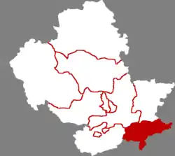
ᠰᡳᠶᠠᠨ; [Möllendorff: kuwanceng manju beye dasangga siyan) is a Manchu autonomous county of northeastern Hebei province, China, on the banks of the Luan River, bordering Liaoning to the east. It is under the administration of Chengde City, and as of 2006, it had a population of 240,000 residing in an area of 1,933 km2 (746 sq mi).
Kuancheng County
宽城县 • ᡴᡠᠸᠠᠨᠴᡝᠩ ᠰᡳᠶᠠᠨ Kwancheng | |
|---|---|
| 宽城满族自治县 ᡴᡠᠸᠠᠨᠴᡝᠩ ᠮᠠᠨᠵᡠ ᠪᡝᠶᡝ ᡩᠠᠰᠠᠩᡤᠠ ᠰᡳᠶᠠᠨ Kuancheng Manchu Autonomous County | |
 Kuancheng in Chengde | |
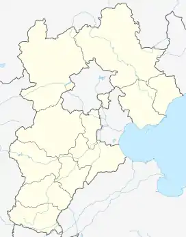 Kuancheng Location of the seat in Hebei | |
| Coordinates: 40°36′40″N 118°29′06″E | |
| Country | People's Republic of China |
| Province | Hebei |
| Prefecture-level city | Chengde |
| County seat | Kuancheng Town (宽城镇) |
| Area | |
| • Total | 1,933 km2 (746 sq mi) |
| Elevation | 303 m (994 ft) |
| Population (2006) | |
| • Total | 240,000 |
| • Density | 120/km2 (320/sq mi) |
| Time zone | UTC+8 (China Standard) |
| Postal code | 067600 |
| Area code(s) | 0314 |
Administrative divisions
There are 7 towns and 11 townships under the county's administration.[1]
Towns:
- Kuancheng (宽城镇)
- Longxumen (龙须门镇)
- Yu'erya (峪耳崖镇)
- Bancheng (板城镇)
- Tangdaohe (汤道河镇)
- Boluotai (饽罗台镇)
- Nianziyu (碾子峪镇)
Townships:
- Huapiliuzi Township (化皮溜子乡)
- Tashan Township (塌山乡)
- Mengziling Township (孟子岭乡)
- Dushigou Township (独石沟乡)
- Dongdadi Township (东大地乡)
- Huajian Township (铧尖乡)
- Donghuanghuachuan Township (东黄花川乡)
- Liangjiatai Township (亮甲台乡)
- Weizigou Township (苇子沟乡)
- Dazigoumen Township (大字沟门乡)
- Dashizhuzi Township (大石柱子乡)
References
- 2011年统计用区划代码和城乡划分代码:宽城满族自治县 (in Chinese). National Bureau of Statistics of the People's Republic of China. Archived from the original on 2012-07-06. Retrieved 2012-07-19.
| Counties |
|    | ||||||
|---|---|---|---|---|---|---|---|---|
| ||||||||
| Authority control |
|---|
This article is issued from Wikipedia. The text is licensed under Creative Commons - Attribution - Sharealike. Additional terms may apply for the media files.