Kurnool district
Kurnool District is one of the four districts in the Rayalaseema region of the Indian state of Andhra Pradesh. The district is located in the west-central part of the state and is bounded by Mahabubnagar district of Telangana in the north, Raichur district of Karnataka in the northwest, Bellary district of Karnataka in the west, Ananthapur district in the south, YSR Kadapa district in the South East and Prakasham district in the east. The city of Kurnool is the headquarters of the district. It has a population of 4,053,463 of which 28.35% were urban as of 2011. The district is the second largest by area and seventh largest by population in the state.[1]:14
Kurnool district | |
|---|---|
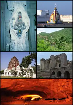 Clockwise from top: Raghavendra Swamy Temple at Mantralayam, Nallamala Hills, Ruined hall in Adoni fort, Belum Caves, Shivanandi temple, Statue of Narasimha at Ahobilam | |
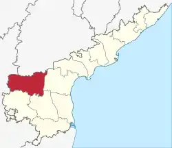 Location of Kurnool district in Andhra Pradesh | |
| Coordinates: 15.811833°N 77.9697606°E | |
| Country | India |
| State | Andhra Pradesh |
| Headquarters | Kurnool |
| Administrative Divisions |
|
| Government | |
| • District collector | Sri G.Veerapandian |
| • Lok Sabha | Lok Sabha list
|
| • Assembly | Assembly list
|
| Area | |
| • Total | 17,658 km2 (6,818 sq mi) |
| • Urban [1]:14 | 347.39 km2 (134.13 sq mi) |
| • Rural [1]:14 | 17,310.61 km2 (6,683.66 sq mi) |
| Area rank | 3rd |
| Population (2011)[2] | |
| • Total | 4,053,463 |
| • Rank | 8th |
| • Density | 230/km2 (600/sq mi) |
| • Density rank | 16th |
| • Urban [1]:14 | 1,149,286 |
| • Rural [1]:14 | 2,904,177 |
| • Households | 887,652 |
| • Sex ratio | 988 (females per 1,000 males) |
| Languages | |
| • Official | Telugu |
| Literacy | |
| • Literates | 2,127,161 |
| Time zone | UTC+5:30 (IST) |
| Postal Index Number | 518xxx |
| Area codes | +91–8518 |
| ISO 3166 code | IN-AP |
| Vehicle registration | AP-21 (former) AP–39 (from 30 January 2019)[3] |
| Website | kurnool |
History
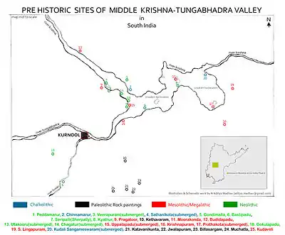
The Ketavaram rock paintings are dated back to the Paleolithic era (located at a distance of 18 km (11 mi) from Kurnool).[4] Jurreru Valley, Katavani Kunta[5] and Yaganti in the district have some important rock arts and paintings in their vicinity, which are dated back to 35,000 to 40,000 years ago.
Belum Caves are geologically and historically important caves in the district. There are indications that Jain and Buddhist monks were occupying these caves centuries ago. Many Buddhists relics were found inside the caves. These relics are now housed in Museum at Anantapur. Archaeological survey of India (ASI) found remnants of vessels and other artifacts of pre-Buddhist era and has dated the remnants of vessels found in the caves to 4500 BC.[6]
Neelam Sanjeeva Reddy (Ananthapur District), the 6th President of India has served as Member of Parliament from Nandyal constituency. He previously served as the Chief Minister of Andhra Pradesh, serving as an MLA from the Dhone assembly constituency. In 1970, part of Kurnool district was split off to become part of Prakasam district.[7] Kurnool District is a part of the Red Corridor.
Geography
Kurnool district occupies an area of approximately 17,658 square kilometres (6,818 sq mi).[8] Kurnool is surrounded by districts of Mahbubnagar district of Telangana to the north, Anantapur district, Kadapa district to south, Prakasam district to east and Bellary of Karnataka to the west. The district includes the Srisailam Dam and a part of the Nallamala Hills, the rest of it lying in Prakasam district, Kadapa district, and Nellore district.
Demographics
| Year | Pop. | ±% p.a. |
|---|---|---|
| 1901 | 950,655 | — |
| 1911 | 1,035,333 | +0.86% |
| 1921 | 987,117 | −0.48% |
| 1931 | 1,120,650 | +1.28% |
| 1941 | 1,222,993 | +0.88% |
| 1951 | 1,315,499 | +0.73% |
| 1961 | 1,570,955 | +1.79% |
| 1971 | 1,982,090 | +2.35% |
| 1981 | 2,407,299 | +1.96% |
| 1991 | 2,973,024 | +2.13% |
| 2001 | 3,529,494 | +1.73% |
| 2011 | 4,053,463 | +1.39% |
| source:[9] | ||
According to the 2011 census Kurnool district has a population of 4,053,463,[10] roughly equal to the nation of Liberia[11] or the US state of Oregon.[12] This gives it a ranking of 54th in India (out of a total of 640). The district has a population density of 229 inhabitants per square kilometre (590/sq mi). Its population growth rate over the decade 2001–2011 was 14.65%. Kurnool has a sex ratio of 984 females for every 1000 males, and a literacy rate of 59.97%.[10]
Scheduled Castes and Scheduled Tribes made up 18.2% and 2% of the population respectively
Religion wise Population Percentage
Household indicators
In 2007–2008 the International Institute for Population Sciences interviewed 1247 households in 38 villages across the district.[14] They found that 94% had access to electricity, 89.7% had drinking water, 34.6% toilet facilities, and 51.6% lived in a pucca (permanent) home.[14] 30.6% of girls wed before the legal age of 18[15] and 85.1% of interviewees carried a BPL card.[14]
Revenue Divisions
Kurnool district has three Revenue divisions viz., Kurnool, Nandyal, Adoni divisions.[16] The district has 54 mandals and 53 Panchayat Samitis (Blocks) under these revenue divisions. It also has a Municipal Corporation of Kurnool and 4 municipalities namely, Nandyal, Adoni, Yemmiganur and Dhone.[17] There are 899 gram panchayats that include 7 notified and 862 non-notified, alongside 920 revenue villages and 615 hamlets.[10] G. Veerapandian is the present district collector.[18]
Mandals

The mandals are listed with respect to their revenue divisions in the following table:[1]:14[19]
Kurnool District has 3 Revenue Divisions viz., Kurnool, Nandyal, Adoni divisions.
Kurnool District Chronicle
- During Independence, Kurnool District was without Adoni, Yemmiganur, Alur Talukas. But It have Markapuram, Giddalur, Yerragondapalem Talukas.
- Later in 1953 Andhra State was formed and Talukas of Adoni, Alur, Yemmiganur were merged with Kurnool District form Bellary District. Remaining Rayalaseema district of Bellary was merged with Karnataka.
- In 1970, new Prakasam District was formed carving out, Markapuram, Giddalur, Yerragondapalem talukas from Kurnool District. Then Kurnool district was remained with 13 Talukas.
Before Formation of Mandal System in 1985, Administration was done through Taluka system. 13 Talukas were present in Kurnool district in 1985 viz.,
| S.No. | Erstwhile Taluka
System in 1971 |
Newly Formed
Taluka System in 1978 |
New Mandals formed in 1985 |
|---|---|---|---|
| 1. | Kurnool | Kurnool | Kurnool [ part ], Kallur, Orvakal |
| Kodumur [12] | Kodumur, Gudur, C.Belagal, Kurnool [ part ] | ||
| 2 | Nandikotkur | Nandikotkur | Nandikotkur, Midthur, Pagidyala, Jupadu Bungalow |
| 3 | Atmakur | Atmakur | Atmakur, Pamulapadu, Kothapalle, Velugodu, Srisailam |
| 4 | Nandyal | Nandyal | Nandyal, Panyam, Gadivemula, Bandi Atmakur, Mahanandi |
| 5 | Allagadda | Allagadda | Allagadda, Sirvella, Chagalamarri, Rudravaram, Gospadu |
| 6 | Koilakuntla | Koilakuntla | Koilakuntla, Sanjamala, Uyyalawada, Dornipadu, Owk [Part] |
| 7 | Banaganapalle | Banaganapalle | Banaganapalle, Owk [Part] |
| 8 | Dhone | Dhone | Dhone, Bethamcherla, Veldurthi, Peapully, Krishnagiri |
| 9 | Pattikonda | Pattikonda | Pattikonda, Devanakonda, Gonegandla, Maddikera, Tuggali, Aspari [ part ] |
| 10 | Adoni | Adoni | Adoni, Kosigi, Kowthalam, PeddaKadabur [ part ] |
| Yemmiganur [13] | Yemmiganur, Mantralayam, Nandavaram, PeddaKadabur [ part ] | ||
| 11 | Alur | Alur | Alur, Chippagiri, Halaharvi, Holagunda, Aspari [ part ] |
These 13 were the erstwhile Talukas in Kurnool district in 1985 before the formation of mandal systems.
Towns in District
Kurnool District has 10 Urban Local Bodies, which are divided into 1 Municipal Corporation, 7 Special Municipalities, 2 Nagar Panchayats.
| S.No. | City / Town | Civic Status of
Municipal Body |
Municipality
Formation Year |
2011 Census
Population |
2001 Census
Population |
1991 Census
Population |
1981 Census
Population |
1971 Census
Population |
1961 Census
Population |
1951 Census
Population |
1941 Census
Population |
|---|---|---|---|---|---|---|---|---|---|---|---|
| 1 | Kurnool | Municipal Corporation | 1866 | 4,84,372 | 342,122 | 275,360 | 206,362 | 136,710 | 100,815 | 60,222 | 45,250 |
| 2 | Nandyal | Special Municipality | 1889 | 211,424 | 157,120 | 119,813 | 88,185 | 63,193 | 42,927 | 33,344 | 25,886 |
| 3 | Adoni | Special Municipality | 1865 | 184,625 | 162,485 | 136,182 | 108,939 | 85,311 | 69,951 | 53,583 | 35,431 |
| 4 | Yemmiganur | Grade - 1 Municipality | 1965 | 95,149 | 76,411 | 65,089 | 50,701 | 30,265 | 21,051 | 15,896 | 12,670 |
| 5 | Dhone | Grade - 2 Municipality | 2005 | 59,272 | 56,450 | 33,434 | 22,509 | 16,047 | 11,247 | 7,871 | 4,828 |
| 6 | Nandikotkur | Grade - 2 Municipality | 2011 | 46,593 | 40,210 | 32,214 | 22,923 | 16,239 | 12,130 | 10,096 | 7,409 |
| 7 | Atmakur | Grade - 3 Municipality | 2011 | 45,703 | 39,794 | 29,599 | 22,132 | 15,837 | 13,217 | 10,960 | 9,609 |
| 8 | Allagadda | Grade - 2 Municipality | 2011 | 41,697 | 37,665 | 21,071 | 18,757 | 13,489 | 6,888 | -- | -- |
| 9 | Bethamcherla | Nagar Panchayat | 2020 | 38,994 | 34,645 | 21,490 | 12,622 | 9,341 | 8,491 | -- | -- |
| 10 | Gudur | Nagar Panchayat | 2011 | 22,270 | 19,805 | 16,515 | 12,466 | 10,915 | 9,078 | -- | -- |
| S.No | Name | Civic Status
of Town |
2011 Census
Population |
2001 Census
Population |
1991 Census
Population |
1981 Census
Population |
1971 Census
Population |
1961 Census
Population |
|---|---|---|---|---|---|---|---|---|
| 1 | Banaganapalle | Census Town | 36,056 | 28,060 | 21,334 | 14,436 | 10,643 | 8,015 |
| 2 | Pattikonda | Grama Panchayat | 29,342 | 24,342 | 19,286 | 14,247 | 12,234 | 9,596 |
| 3 | Kodumur | Grama Panchayat | 28,828 | 25,385 | 19,157 | 14,501 | 11,903 | 9,236 |
| 4 | Koilakuntla | Grama Panchayat | 23,859 | 19,735 | 15,209 | 12,493 | 10,157 | 8,179 |
| 5 | Alur | Grama Panchayat | 14,427 | 11,823 | 10,703 | 8,161 | 7,354 | 6,870 |
| S.No | Name | Municipal Body | 2011 Census
Population |
|---|---|---|---|
| 1 | Kosigi | Grama Panchayat | 23,126 |
| 2 | Velugodu | Grama Panchayat | 23,048 |
| 3 | Chagalamarri | Grama Panchayat | 21,289 |
| 4 | Sirvella | Grama Panchayat | 18,478 |
| 5 | Veldurthi | Grama Panchayat | 17,890 |
| 6 | Gonegandla | Grama Panchayat | 16,691 |
| 7 | Maddikera | Grama Panchayat | 15,328 |
| 8 | Peapully | Grama Panchayat | 15,200 |
| 9 | Holagunda | Grama Panchayat | 14,593 |
| 10 | Panyam | Grama Panchayat | 14,565 |
| 11 | Owk | Grama Panchayat | 11,760 |
| 12 | Kowthalam | Grama Panchayat | 11,670 |
| 13 | Nandavaram | Grama Panchayat | 11,654 |
| 14 | C.Belagal | Grama Panchayat | 11,164 |
| 15 | Mantralayam | Grama Panchayat | 10,613 |
| 16 | Devanakonda | Grama Panchayat | 10,493 |
| 17 | Srisailam | Census Town | 10,382 |
| S.No. | Town | Mandal | Civic status of Town | 2011 Census
Population |
|---|---|---|---|---|
| 1 | Ramapuram | Owk | Census Town | 6,614 |
| 2 | Thummalamenta | Kolimigundla | Census Town | 12,373 |
Economy
The Gross District Domestic Product (GDDP) of the district is ₹34,359 crore (US$4.8 billion) and it contributes 6.5% to the Gross State Domestic Product (GSDP). For the FY 2013–14, the per capita income at current prices was ₹68,197 (US$960). The primary, secondary and tertiary sectors of the district contribute ₹12,035 crore (US$1.7 billion), ₹6,055 crore (US$850 million) and ₹16,269 crore (US$2.3 billion) respectively.[20]
Transport
Roads
The total road length of state highways in the district is 1,169 km (726 mi).[21]
NH - 44 = Srinagar to Kanyakumari.
- Total length of highway is 3,806 km.
- 250 kms of this highway passes through Andhra Pradesh.
- 93 kms of this Highway Passes through Kurnool District
NH - 40 = Kurnool to Ranipet. [Rayalaseema Expressway]
- Total length of highway is 408 Kms.
- 390 Kms of this highway is passing in the Andhra Pradesh.
- 142 kms of this highway passes through Kurnool District.
NH - 167 = Ballari to Kodad
- Total length of Highway is 483 kms
- 94 kms of this Highway Passes through Andhra Pradesh
- 94 kms of this Highway Passes through Kurnool Dist.
NH - 544D = Anantapuramu to Guntur
- Total length of Highway is 417 kms
- 417 kms of this Highway Passes through Andhra Pradesh
- 118 kms of this Highway Passes through Kurnool Dist.
- An alternative route to this highway is under paperwork, called Anantapuram - Amaravathi Expressway which is called as NH-544F
NH - 67 = Ramanagar to Krishnapatnam Port
- Total length of Highway is 770 kms
- 380 kms of this Highway Passes through Andhra Pradesh
- 28 kms of this Highway Passes through Kurnool Dist.
And also Some State Highways also present in Kurnool District.
Railways
Kurnool District is served by Good Railway Connectivity.
- Hyderabad Division of South Central Railway,
- Guntakal Division of South Coastal Railway,
- Guntur Division of South Coastal Railway serves in Kurnool District.
Major lines passing through the district.
- Vijayawada - Hubli Railway Line
- Secunderabad - Bengaluru Railway Line
- Chennai - Mumbai Railway line Passes through the District.
Major Stations
- Dhone JN Railway station [Guntakal Division]
- Kurnool City Railway Station [Hyderabad Division]
- Adoni Railway Station [Guntakal Division]
- Nandyal JN Railway Station [Guntur Division]
Airways
Kurnool Airport was opened in 2019. But only charter Flights of VIP's have been utilising the Airport. Passenger Flights are yet to be started.
Nearest International Airports from Kurnool
- Rajiv Gandhi International Airport, Hyderabad. = 195 km.
- Kempegowda International Airport, Bengaluru. = 335 km.
- Chennai International Airport, Chennai = 450 km.
- Tirupati International Airport , Tirupati = 330 km.
Education
The primary and secondary school education is imparted by government, aided and private schools, under the School Education Department of the state.[22][23] As per the school information report for the academic year 2015–16, there are a total of 4,179 schools. They include, 78 government, 2,398 mandal and zilla parishads, 1 residential, 1,355 private, 33 model, 53 Kasturba Gandhi Balika Vidyalaya (KGBV), 140 municipal and 121 other types of schools.[24] The total number of students enrolled in primary, upper primary and high schools of the district are 631,740.[25]
Tourism
Kurnool District has many pilgrimage centers
- Srisailam
- Mahanandi
- Mantralayam
- Orvakal Rock Gardens
- City Forest [ Gargeyapuram ]
- Yaganti
- Banaganapalli Nawab Bungalow
- Belum Caves
- Kolanu Bharathi Temple
- Adoni Lakshmamma avva Temple
- Urukunda Eranna Swamy Temple
- Maddileti Swamy Temple
- Velugodu Reservoir
- Rollapadu Wildlife Sanctuary
- Nandavaram Temple
 Back Waters of Srisailam Dam
 Maha Nandi Temple
.jpg.webp) Mantralayam
Mantralayam Orvakal Rock Gardens
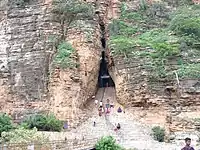 Yaganti Temple Cave
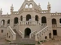 Nawab Bungalow, Banaganapalli
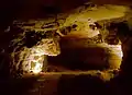 Belum Caves
 Watch Tower in Rollapadu Wild Life Sanctuary
Source
http://dtcp.ap.gov.in/dtcpweb/ulbs/List%20of%20ULBs-27-2-2019.pdf
Population of towns in 1941 were taken from 1991 census book from page no.132,133 and 2011 Census hand book page no.919.
Population of every town is mentioned with proof from census books given below.
1951 census kurnool district - http://lsi.gov.in:8081/jspui/bitstream/123456789/6419/1/50120_1951_KUR.pdf
1961 census kurnool district - http://lsi.gov.in:8081/jspui/bitstream/123456789/2721/1/21648_1961_KUR.pdf
1971 Census kurnool district - http://lsi.gov.in:8081/jspui/bitstream/123456789/2841/1/39378_1971_KUR.pdf
1981 census kurnool district - http://lsi.gov.in:8081/jspui/bitstream/123456789/2915/1/27365_1981_KUR.pdf
1991 census kurnool district - http://lsi.gov.in:8081/jspui/bitstream/123456789/2935/1/39295_1991_KUR.pdf
2001 census kurnool district - http://lsi.gov.in:8081/jspui/bitstream/123456789/2992/1/37985_2001_KUR.pdf
2011 census kurnool district - https://censusindia.gov.in/2011census/dchb/2821_PART_A_DCHB_KURNOOL.pdf
References
- "District Census Hand Book – Guntur" (PDF). Census of India. Registrar General and Census Commissioner of India. Retrieved 9 May 2019.
- "Population". Census of India. Registrar General and Census Commissioner of India. Retrieved 12 June 2019.
- "New 'AP 39' code to register vehicles in Andhra Pradesh launched". The New Indian Express. Vijayawada. 31 January 2019. Retrieved 9 June 2019.
- "archelogical excavations" (PDF). aparchaeologymuseum. Archived from the original (PDF) on 17 December 2013. Retrieved 15 June 2014.
- Michael Petraglia. "New rock art discoveries in the Kurnool District, Andhra Pradesh, India". academia.edu.
- Show Caves of India: Belum Caves
- Law, Gwillim (25 September 2011). "Districts of India". Statoids. Retrieved 11 October 2011.
- Srivastava, Dayawanti, ed. (2010). "States and Union Territories: Andhra Pradesh: Government". India 2010: A Reference Annual (54th ed.). New Delhi, India: Additional Director General, Publications Division, Ministry of Information and Broadcasting (India), Government of India. pp. 1111–1112. ISBN 978-81-230-1617-7.
- Decadal Variation In Population Since 1901
- "District Profile". Kurnool District Official website. Archived from the original on 11 November 2014. Retrieved 20 March 2016.
- US Directorate of Intelligence. "Country Comparison:Population". Retrieved 1 October 2011.
Liberia 3,786,764 July 2011 est.
- "2010 Resident Population Data". U. S. Census Bureau. Archived from the original on 19 October 2013. Retrieved 30 September 2011.
Oregon 3,831,074
- "Andhra Pradesh State Minorities Finance Corporation Ltd. - Downloads". apsmfc.com.
- "District Level Household and Facility Survey (DLHS-3), 2007-08: India. Andhra Pradesh" (PDF). International Institute for Population Sciences and Ministry of Health and Family Welfare. 2010. Retrieved 3 October 2011.
- "How Do I? : Obtain Marriage Certificate". National Portal Content Management Team, National Informatics Centre. 2005. Retrieved 3 October 2011.
To be eligible for marriage, the minimum age limit is 21 for males and 18 for females.
- "Brief Industrial Profile of Kurnool District" (PDF). The office of Development Commissioner (MSME), Ministry of Micro, Small & Medium Enterprises. p. 4. Retrieved 4 November 2014.
- "Part-I State Administrative Divisions 2001–2011" (PDF). Census of India. pp. 359–366. Retrieved 18 January 2015.
- "Days after assuming office, Jagan rejigs administration in AP". Asian News International. 5 June 2019. Retrieved 5 June 2019.
- "Mandals". Kurnool District, Government of Andhra Pradesh. Retrieved 12 June 2019.
- "Economy of Kurnool District". Andhra Pradesh Economic Development Board. Retrieved 25 April 2017.
- "Existing State Highways" (PDF). Andhra Pradesh Road Development Corporation. Government of Andhra Pradesh. p. 1. Archived from the original (PDF) on 20 September 2018. Retrieved 11 May 2019.
- "School Education Department" (PDF). School Education Department, Government of Andhra Pradesh. Archived from the original (PDF) on 27 December 2015. Retrieved 7 November 2016.
- "The Department of School Education – Official AP State Government Portal". www.ap.gov.in. Archived from the original on 7 November 2016. Retrieved 7 November 2016.
- "School Information Report". Commissionerate of School Education. Government of Andhra Pradesh. Archived from the original on 8 November 2016. Retrieved 8 November 2016.
- "Student Information Report". Commissionerate of School Education. Child info 2015–16, District School Education – Andhra Pradesh. Archived from the original on 22 May 2015. Retrieved 8 November 2016.
External links
| Wikimedia Commons has media related to Kurnool district. |
Places adjacent to Kurnool district | |
|---|---|
Capital: Amaravati (de facto & legislative), Visakhapatnam (executive), Kurnool (judicial), Hyderabad (de jure) | |
| Topics | |
| Regions | |
| Districts | |
| Million-plus cities | |
| Cities (population over 1 lakh) |
|
| Tourism |
|
| Related lists | |
| |
| District headquarters | | |
|---|---|---|
| Divisions | ||
| Mandals | ||
| Cities | ||
| Towns | ||
| Census towns | ||