L'Ange-Gardien, Outaouais, Quebec
L'Ange-Gardien (French for "the guardian angel") is a municipality in the Outaouais region of Quebec, Canada. It constitutes the easternmost part of Les Collines-de-l'Outaouais Regional County Municipality, north of the Buckingham Sector of the City of Gatineau.
L'Ange-Gardien | |
|---|---|
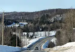 Route 309 in the Du Lièvre River valley. | |
_Quebec_location_diagram.png.webp) Location within Les Collines-de-l'Outaouais RCM | |
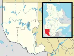 L'Ange-Gardien Location in western Quebec | |
| Coordinates: 45°35′N 75°27′W[1] | |
| Country | |
| Province | |
| Region | Outaouais |
| RCM | Les Collines-de-l'Outaouais |
| Constituted | May 17, 1979 |
| Government | |
| • Mayor | Marc Louis-Seize |
| • Federal riding | Argenteuil—La Petite-Nation |
| • Prov. riding | Papineau |
| Area | |
| • Total | 224.15 km2 (86.54 sq mi) |
| • Land | 218.25 km2 (84.27 sq mi) |
| Population | |
| • Total | 5,464 |
| • Density | 25.0/km2 (65/sq mi) |
| • Pop 2011–2016 | |
| • Dwellings | 2,058 |
| Time zone | UTC−5 (EST) |
| • Summer (DST) | UTC−4 (EDT) |
| Postal code(s) | J8L 0K8 |
| Area code(s) | 819 |
| Highways | |
| Website | municipalitedelangegardien |
The municipality straddles both sides of the Du Lièvre River. The following communities and villages are within its boundaries:
- Glen Almond
- Neilon
- Ribot
History
In 1861, a parish municipality was formed and named L'Ange-Gardien. In 1869, a post office serving the parish and village was established. In 1881, it was separated from Buckingham Canton and formed into a parish municipality.[1] In 1915, the village of Angers was separated from L'Ange-Gardien.
On January 1, 1975, L'Ange-Gardien, Buckingham, Masson, Notre-Dame-de-la-Salette, Angers, Buckingham-South-East, and Buckingham-South-West were merged to form the City of Buckingham, but because of adverse public reaction, the merger did not last long. On January 1, 1980, the former municipalities of West Buckingham, Buckingham Township, and L'Ange-Gardien Parish were reorganized into the Municipality of L'Ange-Gardien.[4]
Demographics
| Canada census – L'Ange-Gardien, Outaouais, Quebec community profile | |||
|---|---|---|---|
| 2016 | 2011 | ||
| Population: | 5,464 (8.2% from 2011) | 5,051 (16.2% from 2006) | |
| Land area: | 218.25 km2 (84.27 sq mi) | 218.49 km2 (84.36 sq mi) | |
| Population density: | 25.0/km2 (65/sq mi) | 23.1/km2 (60/sq mi) | |
| Median age: | 39.0 (M: 39.0, F: 39.0) | 39.9 (M: 40.0, F: 39.9) | |
| Total private dwellings: | 2,058 | 1,952 | |
| Median household income: | $93,440 | $87,509 | |
| References: 2016[5] 2011[6] earlier[7] | |||
| Year | Pop. | ±% |
|---|---|---|
| 1986 | 2,121 | — |
| 1991 | 2,815 | +32.7% |
| 1996 | 3,521 | +25.1% |
| 2001 | 3,610 | +2.5% |
| 2006 | 4,348 | +20.4% |
| 2011 | 5,051 | +16.2% |
| 2016 | 5,464 | +8.2% |
| Source: [8] | ||
Mother tongue:[3]
- English as first language: 9.0%
- French as first language: 88.7%
- English and French as first language: 1.5%
- Other as first language: 0.7%
See also
References
- Reference number 177362 of the Commission de toponymie du Québec (in French)
- Geographic code 82005 in the official Répertoire des municipalités (in French)
- "(Code 2482005) Census Profile". 2016 census. Statistics Canada. 2017.
- "Municipality of L'Ange-Gardien History". Municipalité de L'Ange-Gardien. Archived from the original on 2009-03-14. Retrieved 2008-04-08.
- "2016 Community Profiles". 2016 Canadian Census. Statistics Canada. February 21, 2017. Retrieved 2019-12-12.
- "2011 Community Profiles". 2011 Canadian Census. Statistics Canada. July 5, 2013. Retrieved 2019-12-12.
- "2001 Community Profiles". 2001 Canadian Census. Statistics Canada. February 17, 2012.
- Statistics Canada: 1996, 2001, 2006, 2011 census
External links
 Media related to L'Ange-Gardien, Outaouais, Quebec at Wikimedia Commons
Adjacent Municipal Subdivisions | ||||||||||
|---|---|---|---|---|---|---|---|---|---|---|
| ||||||||||
| Municipalities | |
|---|---|
| |