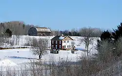
Lochaber-Partie-Ouest, Quebec
Lochaber-Partie-Ouest is a township municipality in the Canadian province of Quebec, located within the Papineau Regional County Municipality. The township had a population of 856 in the 2016 Canadian Census.
Lochaber-Partie-Ouest | |
|---|---|
 | |
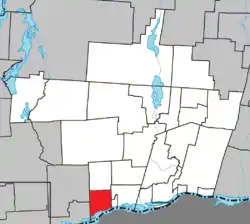 Location within Papineau RCM | |
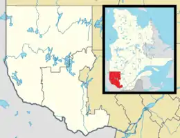 Lochaber-Partie-Ouest Location in western Quebec | |
| Coordinates: 45°37′N 75°18′W[1] | |
| Country | |
| Province | |
| Region | Outaouais |
| RCM | Papineau |
| Constituted | April 20, 1891 |
| Government | |
| • Mayor | Pierre Renaud[3] |
| • Federal riding | Argenteuil—Papineau—Mirabel |
| • Prov. riding | Papineau |
| Area | |
| • Total | 66.00 km2 (25.48 sq mi) |
| • Land | 57.45 km2 (22.18 sq mi) |
| Population (2016)[4] | |
| • Total | 856 |
| • Density | 14.9/km2 (39/sq mi) |
| • Pop 2011-2016 | |
| • Dwellings | 339 |
| Time zone | UTC−5 (EST) |
| • Summer (DST) | UTC−4 (EDT) |
| Postal code(s) | J0X 3B0 |
| Area code(s) | 819 |
| Highways | |
| Website | www |
The township is predominantly agricultural which is the main economic activity.[5]
History
In 1807, a group of about 400 Scottish Highlanders settled in the area, the same year the geographic township of Lochaber Gore was created. They came from the Highlands, near Lochaber and other parts of northern Scotland. Settlement was difficult, because income from agriculture was lower than the costs of importing manufactured products from Montreal.[5][6]
With the arrival of the logging industry, the settlers were able to practice agriculture during the summer, while working in the lumberjack camps during the winter, or to work in the various sawmills that developed along the Blanche River near Thurso. The logging industry also attracted many more settlers, including French Canadians, and settlement was well underway at the turn of the 19th to 20th century. The population became predominantly Francophone at the start of the 20th century.[5]
In 1891, the township municipality of Lochaber-Partie-Ouest was created when it was split off from Lochaber Township.[1]
Demographics
| Canada census – Lochaber-Partie-Ouest, Quebec community profile | |||
|---|---|---|---|
| 2016 | 2011 | ||
| Population: | 856 (32.5% from 2011) | 646 (25.7% from 2006) | |
| Land area: | 57.45 km2 (22.18 sq mi) | 57.41 km2 (22.17 sq mi) | |
| Population density: | 14.9/km2 (39/sq mi) | 11.3/km2 (29/sq mi) | |
| Median age: | 41.6 (M: 42.0, F: 40.8) | 40.0 (M: 40.9, F: 39.1) | |
| Total private dwellings: | 339 | 248 | |
| Median household income: | $81,067 | $54,239 | |
| References: 2016[7] 2011[8] earlier[9] | |||
| Year | Pop. | ±% |
|---|---|---|
| 1986 | 504 | — |
| 1991 | 470 | −6.7% |
| 1996 | 477 | +1.5% |
| 2001 | 460 | −3.6% |
| 2006 | 514 | +11.7% |
| 2011 | 646 | +25.7% |
| 2016 | 856 | +32.5% |
| Source: Statistics Canada | ||
Mother tongue:[4]
- English as first language: 8.1%
- French as first language: 90.1%
- English and French as first language: 1.2%
- Other as first language: 1.2%
Local government
List of former mayors:
- Michel Labrecque (2001–2009)
- Jean-Pierre Girard (2013–2017)
- Pierre Renaud (2017–present)
References
- Reference number 36337 of the Commission de toponymie du Québec (in French)
- Geographic code 80060 in the official Répertoire des municipalités (in French)
- http://www.lochaber-ouest.ca/municipalite/?id=7&lng=fr
- "(Code 2480060) Census Profile". 2016 census. Statistics Canada. 2017.
- "Portrait du Canton - Historique du Canton". www.lochaber-ouest.ca. Canton de Lochaber-Partie-Ouest. Retrieved 20 January 2020.
- "Thurso" (in French). Commission de toponymie du Québec. Retrieved 2020-01-20.
- "2016 Community Profiles". 2016 Canadian Census. Statistics Canada. February 21, 2017. Retrieved 2020-01-20.
- "2011 Community Profiles". 2011 Canadian Census. Statistics Canada. July 5, 2013. Retrieved 2020-01-20.
- "2001 Community Profiles". 2001 Canadian Census. Statistics Canada. February 17, 2012.
External links
![]() Media related to Lochaber-Partie-Ouest at Wikimedia Commons
Media related to Lochaber-Partie-Ouest at Wikimedia Commons
Places adjacent to Lochaber-Partie-Ouest, Quebec | ||||||||||
|---|---|---|---|---|---|---|---|---|---|---|
| ||||||||||
| Cities | |
|---|---|
| Municipalities | |
| Townships | |
| |