Mayo, Quebec
Mayo is a municipality in the Papineau Regional County Municipality of western Quebec, located northeast of the city of Gatineau (Buckingham sector). Mayo is south of the hamlet of Mulgrave-et-Derry.
Mayo | |
|---|---|
 | |
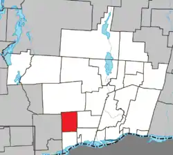 Location within Papineau RCM | |
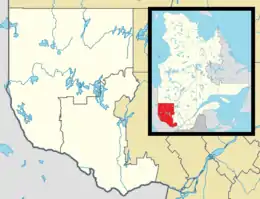 Mayo Location in western Quebec | |
| Coordinates: 45°40′N 75°21′W[1] | |
| Country | |
| Province | |
| Region | Outaouais |
| RCM | Papineau |
| Constituted | August 1, 1864 |
| Government | |
| • Mayor | Gaëtan Brunet |
| • Federal riding | Argenteuil—Papineau—Mirabel |
| • Prov. riding | Papineau |
| Area | |
| • Total | 77.50 km2 (29.92 sq mi) |
| • Land | 73.25 km2 (28.28 sq mi) |
| Population (2016)[3] | |
| • Total | 601 |
| • Density | 8.2/km2 (21/sq mi) |
| • Pop 2011-2016 | |
| • Dwellings | 403 |
| Time zone | UTC−5 (EST) |
| • Summer (DST) | UTC−4 (EDT) |
| Postal code(s) | J8L 4J7 |
| Area code(s) | 819 |
| Highways | |
History
The area which would become the municipality of Mayo in 1864, just north of the township of Lochaber, began to be settled in the nineteenth century mainly by Irish and German immigrants as well as French Canadians.[4] The Irish settlers arrived in Mayo between 1820-1830, pre-famine immigrants. They would have arrived in Montreal and traveled along the Ottawa river and then along the Blanche River. The settlers would have found great comfort in their new surroundings, the hilly terrain resembling that of Ireland, and subsequently their new home was named Mayo after County Mayo in Ireland.[5] The main industries which drive the economics of the municipality were, and still are, farming and forestry as well as the manufacturing of potash.[4]
Demographics
| Canada census – Mayo, Quebec community profile | |||
|---|---|---|---|
| 2016 | 2011 | ||
| Population: | 601 (5.1% from 2011) | 572 (4.2% from 2006) | |
| Land area: | 73.25 km2 (28.28 sq mi) | 72.06 km2 (27.82 sq mi) | |
| Population density: | 8.2/km2 (21/sq mi) | 7.9/km2 (20/sq mi) | |
| Median age: | 43.6 (M: 43.6, F: 43.7) | 47.6 (M: 46.9, F: 47.9) | |
| Total private dwellings: | 403 | 347 | |
| Median household income: | $68,992 | $39,824 | |
| References: 2016[6] 2011[7] earlier[8] | |||
| Year | Pop. | ±% |
|---|---|---|
| 1986 | 338 | — |
| 1991 | 370 | +9.5% |
| 1996 | 401 | +8.4% |
| 2001 | 443 | +10.5% |
| 2006 | 549 | +23.9% |
| 2011 | 572 | +4.2% |
| 2016 | 601 | +5.1% |
| Source: Statistics Canada | ||
Mother tongue:[3]
- English as first language: 28.1%
- French as first language: 68.6%
- English and French as first language: 1.7%
- Other as first language: 1.7%
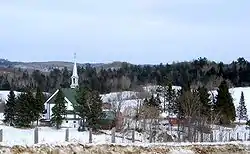
Our Lady of Knock Shrine
The people of Mayo had a strong connection with their Irish roots. The parish of St. Malachy in Mayo was very important in the municipality's connection with Ireland. In County Mayo, Ireland there is a town called Knock where, in 1879, there were reports of an apparition of the Virgin Mary, St. Joseph and St. John. The story of this miracle was brought to Canada as early as 1882, and in 1949 the then pastor of St. Malachy, Father Braceland, was inspired to construct a replica of the Our Lady of Knock Shrine in Mayo.[9]
La Blanche Forest
The La Blanche forest, located on the eastern shores of La Blanche Lake in Mayo and Mulgrave-et-Derry, contains rare old-growth forest and many endangered plant species such as ginseng. The forest is protected in the Forêt-la-Blanche Ecological Reserve, a 20.52 square kilometres (7.92 sq mi) area of preservation for this forest which has been sheltered from disturbance for centuries. The forest is also home to many species of rare birds such as the blue heron and the cerulean warbler.[10] The La Blanche forest was designated a permanent protected area in October 2003 giving it the legal distinction of an ecological reserve, the highest protection possible in Quebec[11]
References
- Reference number 39941 of the Commission de toponymie du Québec (in French)
- Municipalité: Mayo - Répertoire des municipalités du Québec - MAMR, Retrieved September 22, 2007
- "(Code 2480065) Census Profile". 2016 census. Statistics Canada. 2017.
- MRC Papineau, Les Municipalités, Mayo (2006), Retrieved on September 21, 2007.
- Our Lady of Victory/ St. Malachy, Pilgrimage (2004), Retrieved on September 21, 2007.
- "2016 Community Profiles". 2016 Canadian Census. Statistics Canada. February 21, 2017. Retrieved 2020-01-22.
- "2011 Community Profiles". 2011 Canadian Census. Statistics Canada. July 5, 2013. Retrieved 2020-01-22.
- "2001 Community Profiles". 2001 Canadian Census. Statistics Canada. February 17, 2012.
- Our Lady of Victory/ St. Malachy, Pilgrimage (2004), Retrieved on September 21, 2007.
- Ecological Reserve Archived 2007-10-09 at the Wayback Machine, La Blanche Ecological Reserve , Retrieved on September 24, 2007.
- Canadian Parks and Wilderness Society Archived 2007-10-27 at the Wayback Machine, CPAWS Ottawa Valley Chapter (2004), Retrieved on September 24, 2007.
External links
![]() Media related to Mayo, Quebec at Wikimedia Commons
Media related to Mayo, Quebec at Wikimedia Commons
Places adjacent to Mayo, Quebec | |
|---|---|
| Cities | |
|---|---|
| Municipalities | |
| Townships | |
| |
| Authority control |
|---|
