La Altagracia Province
La Altagracia (Spanish pronunciation: [la altaˈɣɾasja]) is the easternmost province of the Dominican Republic. Punta Cana is located on the eastern shores of this province. The province was part of the old La Altagracia Province, which split into 2, La Altagracia Province and La Romana Province on February 27, 1961.
La Altagracia | |
|---|---|
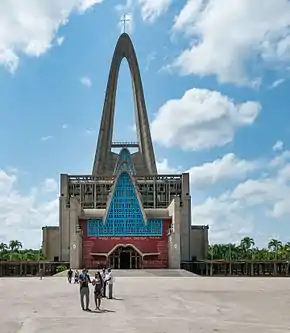 Cathedral of Higuey in La Altagracia province, Dominican Republic. | |
 Coat of arms | |
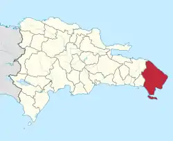 Location of the La Altagracia Province | |
| Country | |
| Province since | 1944 |
| Government | |
| • Type | Subdivisions |
| • Body | 2 municipalities 5 municipal districts |
| • Congresspersons | 1 Senator 4 Deputies |
| Area | |
| • Total | 3,010.34 km2 (1,162.30 sq mi) |
| Population (2014) | |
| • Total | 372,289 |
| • Density | 120/km2 (320/sq mi) |
| Time zone | UTC-4 (EST) |
| Area code | 1-809 1-829 1-849 |
| ISO 3166-2 | DO-11 |
| Postal Code | 23000 |
The name "La Altagracia" commemorates a painting, Our Lady of La Altagracia, which was brought to this area from Spain in the early 16th century. Numerous miracles are attributed to the image.
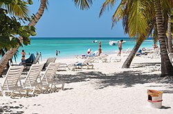
Currently it is the leading province of the country in terms of tourism, this province has the luxury of having the Punta Cana International Airport which is the most important airport on the island.
Geography
La Altagracia is the second largest province in the country with an extension of 3,010.34 km². This province limits to the north with the Atlantic Ocean, to the south with the Caribbean Sea, to the east with the Mona channel and to the west with the provinces of La Romana and El Seibo.
The most important river in the province is the Yuma, other rivers of consideration are in Duey, Maimon, Chavon, Anamuya, Sanate and Yonu. La Altagracia is part of the coastal plains of the Caribbean, so the southern part of the province presents a flat relief in constrast to other parts of the country. Towards the north are the foothills of the Eastern Cordillera, where the Old Hill rises, which with its 736 meters high is the highest in the province.
History
By 1505, Juan de Esquivel conquered the Taino chiefdom of Higuey and founded a fortress which he converted in 1506 by order of Ovando into a town, calling it Salvaleón de Higuey.
Years later, by Royal Privilege dispatched from Seville on December 7, 1508, this town was awarded the Coat of Arms. During the Spanish colonial period, Higüey remained as the Parish of the Seibo party. When the Republic was proclaimed in 1844, the Central Government Board designated it as a common part of the Department of El Seibo.
It was not until 1959, during the dictatorship of Rafael Leónidas Trujillo, that the province of La Altagracia was officially created, occupying the eastern part of what belonged to the province of La Romana, which at that time was called Altagracia already for in 1945 when Higüey was elevated to a province under the name of Altagracia.
Municipalities and municipal districts
The province as of June 20, 2006 is divided into the following municipalities (municipios) and municipal districts (distrito municipal - M.D.) within them:[1]
- Salvaleón de Higüey
- Lagunas de Nisibon (M.D.)
- La Otra Banda (M.D.)
- Verón-Punta Cana (M.D.)
- San Rafael del Yuma
- Boca de Yuma (M.D.)
- Bayahibe (M.D.)
- Saona
- Isla Catalina (M.D.)
The following is a sortable table of the municipalities and municipal districts with population figures as of the 2014 estimate. Urban population are those living in the seats (cabeceras literally heads) of municipalities or of municipal districts. Rural population are those living in the districts (Secciones literally sections) and neighborhoods (Parajes literally places) outside them. The population figures are from the 2014 population estimate.[2] For comparison with the municipalities and municipal districts of other provinces see the list of municipalities and municipal districts of the Dominican Republic.
| Name | Total population | Urban population | Rural population |
|---|---|---|---|
| Higüey | 322,266 | 281,061 | 41,205 |
| San Rafael del Yuma | 50,023 | 31,482 | 18,541 |
| La Altagracia province | 372,289 | 312,543 | 59,746 |
References
- Oficina Nacional de Estadistica, Departamento de Cartografia, Division de Limites y Linderos. "Listado de Codigos de Provincias, Municipio y Distritos Municipales, Actualizada a Junio 20 del 2006" (in Spanish). Archived from the original on 2007-03-14. Retrieved 2007-01-24.CS1 maint: multiple names: authors list (link)
- Consejo Nacional de Población y Familia. "Estamaciones y Proyecciones de la Población Dominicana por Regiones, Provincias, Municipios y Distritos Municipales, 2014" (in Spanish). Archived from the original (PDF) on 2014-02-02. Retrieved 2014-02-02.
External links
| Wikimedia Commons has media related to La Altagracia Province. |
- (in Spanish) Oficina Nacional de Estadística, Statistics Portal of the Dominican Republic
- (in Spanish) Oficina Nacional de Estadística, Maps with administrative division of the provinces of the Dominican Republic, downloadable in PDF format