Pedernales Province
Pedernales (from Spanish 'Flints'; pronounced [peðeɾˈnales]) is the southernmost province of the Dominican Republic, including the offshore island of Isla Beata. It was split from Barahona in 1957. Of its 2,074.53 km², 1374 km² belong to the Jaragua National Park.
Pedernales | |
|---|---|
.JPG.webp) Jaragua National Park in Pedernales, Dominican Republic | |
 Coat of arms | |
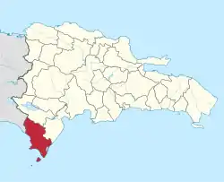 Location of the Pedernales Province | |
| Country | |
| Province since | 1957 |
| Capital | Pedernales |
| Government | |
| • Type | Subdivisions |
| • Body | 2 municipalities 2 municipal districts |
| • Congresspersons | 1 Senator 2 Deputies |
| Area | |
| • Total | 2,074.53 km2 (800.98 sq mi) |
| Population (2014) | |
| • Total | 52,165 |
| • Density | 25/km2 (65/sq mi) |
| Time zone | UTC-4 (AST) |
| Area code | 1-809 1-829 1-849 |
| ISO 3166-2 | DO-16 |
| Postal Code | 84000 |
The town of Pedernales was originally called Juan López, who was a Spanish inhabitant who had settled in the area around the 19th century.
The province was called Pedernales after the river located on the border with the Republic of Haiti, in which common yellow quartz stones are found, called flint. With this stone, the ancient inhabitants of the Dominican Republic, the Tainos, made sharp tools such as axes and arrowheads.
Geography
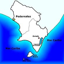
The province of Pedernales is located in the southwest of the Dominican Republic, sharing its borders with the neighboring Haiti. It is located 330 km (kilometers) from Santo Domingo, the Dominican capital. It is part of the region called Enriquillo, and it is the seventh largest province in the country with 2,042.40 km² (square kilometers). Its limits are: to the north the province of Independencia, to the east the province of Barahona.
Pedernales is located in a geomorphological region known as Procurrente de Barahona. The area of Pedernales has some of the most arid lands in the country. It is formed by successive marine terraces. The lowest part of these is on the edge of the coast, less than 100 m s. n. m. (meters above sea level). As you move away from the sea, the elevations grow to 400 m s. n. m. Upon entering the north, the ground continues to rise up to the Sierra de Bahoruco. Here is the mount Vincent, with about 2046 ms. n. m., which is the top of the province.
The territory of Pedernales has several adjacent lands, such as Isla Beata, Islote Los Frailes, Isla Alto Velo and Cayo Piedra Negra making it a strategic place for fishermen. Historically it was considered important as it served as an orientation for Spanish and French ships during the colonial era that wanted to reach the Western expanse of the island. In addition, its natural conditions allow the nesting of seabirds and other endemic species.
History
.jpg.webp)
The first settlers of the island of Hispaniola, the Taínos, arrived there around the 8th century AD. C., and that their culture comes from the Arawaks, a group of people who come from the Orinoco River, Venezuela. They lived from agriculture, fishing, hunting, and gathering fruits.
At that time the island was divided into 5 chiefdoms or regions. The Province of Pedernales occupies the territory of what was previously the chiefdom of Jaragua. When the Spanish arrived, Cacique Bohechío was the head of this chiefdom. The inhabitants of this land were characterized by their rebellion, since they were against the oppression that the Spanish subjected them. During the sixteenth century, this land was a refuge for the chief Enriquillo, a Taíno prince, as he was rebelling.
In 1493, Christopher Columbus discovered Beata Island, a strategic point for ships, due to its geographical location. This attracted several people who later settled on the shores of this island. Also, the Spanish kept cattle on the island for the new maritime expeditions.
When Hispaniola was divided into a French and a Spanish colony, the Pedernales River was set as a border limit. From 1844, until the signing of the territorial division treaty (1929-1936), there were several incidents and border conflicts in the Enriquillo and Pedernales region. In 1867 the island of Alto Velo was granted to a North American company. Salt extraction was also started in the Beata lagoons.
The colonization of Pedernales began in 1927, during the government of Horacio Vásquez. This is included in the border colonization plan, which aimed to integrate that area with the rest of the country.
Its first administrator was Socrates Nolasco, appointed on April 13, 1927 by Rafael Espaillat, Minister of Agriculture and Immigration. He was in charge of coordinating the construction of the first town of Pedernales. Pedernales was created on December 16, 1957. It is named after the capital and the most important river in the region.
Economy and population
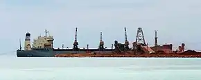
The main activity in the province is currently agriculture, producing coffee and beef cattle. Fishing is also an important activity, being one of the provinces with the highest catch of fish, lobsters, lambí. Limestone mining in Cabo Rojo is also important although it does not have the importance of previous years.
The number of farms in this province amounts to a total of 1,128, which represents only 0.004% of the total number of farms in the country. Though relatively arid Pedernales has some areas where the land can be very fertile, mainly based on irrigation canals. This has allowed the cultivation of products such as: cotton, beans, peanuts, bananas, cassava, coffee, bananas, corn, tobacco, coconut, among others.

According to statistical data Pedernales is the least densely populated province in the Dominican Republic. For 2010, the total population reached 31,587 people: 16,895 men and 14,692 women, with a density of 15.7 inhabitants / km² (inhabitants per square kilometer). The predominant ethnic groups are 78% mulatto or mestizo, 13% black and 9% white.
Until 1927 before the Rafael Trujillo regime, the area was inhabited almost entirely by Haitians. Together with the founding of the province, the government imposed measures to raise the Dominican population, stop the Haitian migration, and make Pedernales a place of Dominican expansion.
Municipalities and municipal districts
The province as of June 20, 2006 is divided into the following municipalities (municipios) and municipal districts (distrito municipal - M.D.) within them:[1]
- Pedernales, head municipality of the province
- José Francisco Peña Gómez (M.D.)
- Oviedo
- Juancho (M.D.)
The following is a sortable table of the municipalities and municipal districts with population figures as of the 2012 census. Urban population are those living in the seats (cabeceras literally heads) of municipalities or of municipal districts. Rural population are those living in the districts (Secciones literally sections) and neighborhoods (Parajes literally places) outside of them.[2]
For comparison with the municipalities and municipal districts of other provinces see the list of municipalities and municipal districts of the Dominican Republic.
| Name | Total population | Urban population | Rural population |
|---|---|---|---|
| Oviedo | 10,986 | 3,699 | 7,287 |
| Pedernales | 27,955 | 16,967 | 10,988 |
| Pedernales province | 38,941 | 20,666 | 18,275 |
References
- Oficina Nacional de Estadistica, Departamento de Cartografia, Division de Limites y Linderos. "Listado de Codigos de Provincias, Municipio y Distritos Municipales, Actualizada a Junio 20 del 2006" (in Spanish). Archived from the original on March 14, 2007. Retrieved 2007-01-24.CS1 maint: multiple names: authors list (link)
- Consejo Nacional de Población y Familia. "Censos y Proyecciones de la Población Dominicana por Regiones, Provincias, Municipios y Distritos Municipales, 2012" (PDF) (in Spanish). Retrieved 2012-01-11.
- (in Spanish) Oficina Nacional de Estadística, Statistics Portal of the Dominican Republic
- (in Spanish) Oficina Nacional de Estadística, Maps with administrative division of the provinces of the Dominican Republic, downloadable in PDF format