Puerto Plata Province
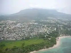
Puerto Plata (Spanish pronunciation: [pweɾtoˈplata], Silver Port) is one of the northern provinces of the Dominican Republic. The area has become an increasingly popular tourist attraction since the late 1990s mainly due to its fine beaches. It borders the Septentrional mountain range to the north (which separates it from Laguna Salada).
Puerto Plata | |
|---|---|
 Coat of arms | |
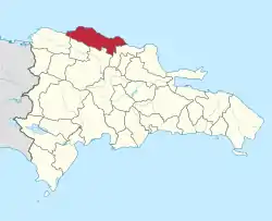 Location of the Puerto Plata Province | |
| Coordinates: 19°44′12″N 70°46′12″W | |
| Country | |
| Province since | 1850 |
| Capital | San Felipe de Puerto Plata |
| Government | |
| • Type | Subdivisions |
| • Body | 9 municipalities 12 municipal districts |
| • Congresspersons | 1 Senator 6 Deputies |
| Area | |
| • Total | 1,852.90 km2 (715.41 sq mi) |
| Population (2014) | |
| • Total | 470,839 |
| • Density | 250/km2 (660/sq mi) |
| Time zone | UTC-4 (AST) |
| Area code | 1-809 1-829 1-849 |
| ISO 3166-2 | DO-18 |
| Postal Code | 57000 |
Created from the Santiago Province in 1867 as a "maritime district", it became a province in 1907, when maritime districts were suppressed by a new Dominican constitution.
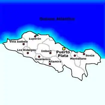
Municipalities and municipal districts
The province is divided into the following municipalities (municipios) and municipal districts (distrito municipal - D.M.) within them:[1]
- San Felipe de Puerto Plata
- Maimón (D.M.)
- Yásica Arriba (D.M.)
- Altamira
- Río Grande (D.M.)
- Guananico
- Imbert
- Los Hidalgos
- Cerro de Navas (D.M.)
- Luperón
- Los Bellosos (D.M.)
- La Isabela (D.M.)
- Sosúa
- Cabarete (D.M.)
- Sabaneta de Yásica (D.M.)
- Villa Isabela
- Estero Hondo (D.M.)
- La Jaiba (D.M.)
- Gualete (D.M.)
- Villa Montellano
The following is a sortable table of the municipalities with population figures as of the 2012 census (the last national census). Urban population are those living in the seats (cabeceras literally heads) of municipalities or of municipal districts. Rural population are those living in the districts (Secciones literally sections) and neighborhoods (Parajes literally places) outside of them.[2]
| Name | Total population | Urban population | Rural population |
|---|---|---|---|
| Altamira | 26,056 | 7,889 | 18,167 |
| Guananico | 8,954 | 3,025 | 5,929 |
| Imbert | 30,514 | 14,589 | 15,925 |
| Los Hidalgos | 14,589 | 3,022 | 11,567 |
| Luperón | 20,259 | 4,989 | 15,270 |
| San Felipe de Puerto Plata | 286,558 | 247,569 | 38,989 |
| Sosúa | 69,885 | 19,338 | 50,547 |
| Villa Isabela | 14,889 | 1,058 | 13,831 |
| Villa Montellano | 19,029 | 9,009 | 10,020 |
| Puerto Plata province | 490,733 | 310,488 | 180,245 |
For comparison with the municipalities and municipal districts of other provinces see the list of municipalities and municipal districts of the Dominican Republic.
References
- Oficina Nacional de Estadistica, Departamento de Cartografia, Division de Limites y Linderos. "Listado de Codigos de Provincias, Municipio y Distritos Municipales, Actualizada a Junio 20 del 2006" (in Spanish). Archived from the original on 2007-03-14. Retrieved 2007-01-24.CS1 maint: multiple names: authors list (link)
- Consejo Nacional de Población y Familia. "Censos y Proyecciones de la Población Dominicana por Regiones, Provincias, Municipios y Distritos Municipales, 2012" (PDF) (in Spanish). Retrieved 2010-10-11.
External links
- (in Spanish) Oficina Nacional de Estadística, Statistics Portal of the Dominican Republic
- (in Spanish) Oficina Nacional de Estadística, Maps with administrative division of the provinces of the Dominican Republic, downloadable in PDF format