La Bâtie-Neuve
La Bâtie-Neuve is a commune in the Hautes-Alpes department in southeastern France.
La Bâtie-Neuve | |
|---|---|
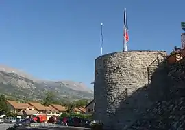 The tower, the only remains of the ancient castle of La Bâtie-Neuve | |
 Coat of arms | |
Location of La Bâtie-Neuve 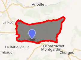
| |
 La Bâtie-Neuve  La Bâtie-Neuve | |
| Coordinates: 44°34′03″N 6°11′47″E | |
| Country | France |
| Region | Provence-Alpes-Côte d'Azur |
| Department | Hautes-Alpes |
| Arrondissement | Gap |
| Canton | Chorges |
| Intercommunality | Avance |
| Government | |
| • Mayor (2008–2014) | Joel Bonnafoux |
| Area 1 | 27.99 km2 (10.81 sq mi) |
| Population (2017-01-01)[1] | 2,534 |
| • Density | 91/km2 (230/sq mi) |
| Time zone | UTC+01:00 (CET) |
| • Summer (DST) | UTC+02:00 (CEST) |
| INSEE/Postal code | 05017 /05230 |
| Elevation | 824–2,420 m (2,703–7,940 ft) (avg. 855 m or 2,805 ft) |
| 1 French Land Register data, which excludes lakes, ponds, glaciers > 1 km2 (0.386 sq mi or 247 acres) and river estuaries. | |
Location
The village is 5 km (3.1 mi) away from La Bâtie-Vieille. It is close to Gap.
Population
| Year | Pop. | ±% |
|---|---|---|
| 1793 | 808 | — |
| 1800 | 794 | −1.7% |
| 1806 | 851 | +7.2% |
| 1821 | 716 | −15.9% |
| 1831 | 855 | +19.4% |
| 1836 | 821 | −4.0% |
| 1841 | 830 | +1.1% |
| 1846 | 905 | +9.0% |
| 1851 | 851 | −6.0% |
| 1856 | 840 | −1.3% |
| 1861 | 767 | −8.7% |
| 1866 | 798 | +4.0% |
| 1872 | 766 | −4.0% |
| 1876 | 773 | +0.9% |
| 1881 | 947 | +22.5% |
| 1886 | 820 | −13.4% |
| 1891 | 752 | −8.3% |
| 1896 | 694 | −7.7% |
| 1901 | 656 | −5.5% |
| 1906 | 623 | −5.0% |
| 1911 | 620 | −0.5% |
| 1921 | 554 | −10.6% |
| 1926 | 608 | +9.7% |
| 1931 | 573 | −5.8% |
| 1936 | 638 | +11.3% |
| 1946 | 518 | −18.8% |
| 1954 | 474 | −8.5% |
| 1962 | 528 | +11.4% |
| 1968 | 510 | −3.4% |
| 1975 | 627 | +22.9% |
| 1982 | 837 | +33.5% |
| 1990 | 1,327 | +58.5% |
| 1999 | 1,692 | +27.5% |
| 2008 | 2,116 | +25.1% |
References
- "Populations légales 2017". INSEE. Retrieved 6 January 2020.
| Wikimedia Commons has media related to La Bâtie-Neuve. |
This article is issued from Wikipedia. The text is licensed under Creative Commons - Attribution - Sharealike. Additional terms may apply for the media files.