Prunières, Hautes-Alpes
Prunières is a commune in the Hautes Alpes department in southeastern France.
Prunières | |
|---|---|
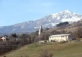 The church and surrounding area, in Prunières | |
 Coat of arms | |
Location of Prunières 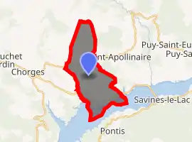
| |
 Prunières  Prunières | |
| Coordinates: 44°32′34″N 6°20′03″E | |
| Country | France |
| Region | Provence-Alpes-Côte d'Azur |
| Department | Hautes-Alpes |
| Arrondissement | Gap |
| Canton | Chorges |
| Government | |
| • Mayor (2008–2014) | René Fusina |
| Area 1 | 13.2 km2 (5.1 sq mi) |
| Population (2017-01-01)[1] | 298 |
| • Density | 23/km2 (58/sq mi) |
| Time zone | UTC+01:00 (CET) |
| • Summer (DST) | UTC+02:00 (CEST) |
| INSEE/Postal code | 05106 /05230 |
| Elevation | 770–2,390 m (2,530–7,840 ft) (avg. 1,000 m or 3,300 ft) |
| 1 French Land Register data, which excludes lakes, ponds, glaciers > 1 km2 (0.386 sq mi or 247 acres) and river estuaries. | |
Geography
It is close to Chorges which is the closest commerce town. Bigger towns near Prunières include Gap (25 km) to the west or Embrun (15 km) to the east. Prunières is located close to the Lac de Serre-Ponçon, one of the largest artificial lakes in Western Europe, and surrounded by gorgeous mountains.
Population
| Year | Pop. | ±% |
|---|---|---|
| 1962 | 154 | — |
| 1968 | 154 | +0.0% |
| 1975 | 121 | −21.4% |
| 1982 | 138 | +14.0% |
| 1990 | 175 | +26.8% |
| 1999 | 232 | +32.6% |
| 2008 | 289 | +24.6% |
Tourism
The main activity in the winter is skiing, while one can enjoy mountain climbing/hiking and water activities on the Lac de Serre-Ponçon.
References
- "Populations légales 2017". INSEE. Retrieved 6 January 2020.
| Wikimedia Commons has media related to Prunières, Hautes-Alpes. |
This article is issued from Wikipedia. The text is licensed under Creative Commons - Attribution - Sharealike. Additional terms may apply for the media files.