La Boissière-École
La Boissière-École (French: [la.bwasjɛʁ‿ekɔl] (![]() listen)) is a commune in the Yvelines department in north-central France.
listen)) is a commune in the Yvelines department in north-central France.
La Boissière-École | |
|---|---|
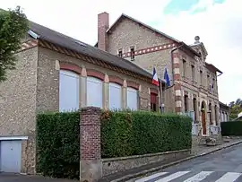 Town hall | |
.svg.png.webp) Coat of arms | |
Location of La Boissière-École 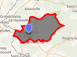
| |
 La Boissière-École  La Boissière-École | |
| Coordinates: 48°40′59″N 1°38′35″E | |
| Country | France |
| Region | Île-de-France |
| Department | Yvelines |
| Arrondissement | Rambouillet |
| Canton | Rambouillet |
| Government | |
| • Mayor (2014–2020) | Anne-Françoise Gaillot |
| Area 1 | 25.06 km2 (9.68 sq mi) |
| Population (2017-01-01)[1] | 765 |
| • Density | 31/km2 (79/sq mi) |
| Time zone | UTC+01:00 (CET) |
| • Summer (DST) | UTC+02:00 (CEST) |
| INSEE/Postal code | 78077 /78125 |
| Elevation | 126–184 m (413–604 ft) (avg. 171 m or 561 ft) |
| 1 French Land Register data, which excludes lakes, ponds, glaciers > 1 km2 (0.386 sq mi or 247 acres) and river estuaries. | |
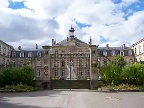
Hériot orphanage and school
Geography
The village is located in the Southern West of Yvelines. Most of the landscape is constituted of forest. The place is separated in two. The castle and the Olympe Hériot school are in "La Basse Boissière" but most of the inhabitants live in "La Haute Boissière". La Gâtine and Mauzaize are in the west of the village centre. Nearby villages include Adainville, Condé-sur-Vesgre, Poigny-la-Forêt, Hermeray, Mittainville, and La Hauteville. It can be reached by the 71 road and the 80.
Economy
In the east of the village, tourists can enjoy an equestrian centre. The principal activity of the village is farming: "La Tremblay".
See also
References
- "Populations légales 2017". INSEE. Retrieved 6 January 2020.
| Wikimedia Commons has media related to La Boissière-École. |
| Authority control |
|---|
This article is issued from Wikipedia. The text is licensed under Creative Commons - Attribution - Sharealike. Additional terms may apply for the media files.