Saint-Léger-en-Yvelines
Saint-Léger-en-Yvelines is a commune in the Yvelines department in the Île-de-France in north-central France.
Saint-Léger-en-Yvelines | |
|---|---|
 Town hall | |
Location of Saint-Léger-en-Yvelines 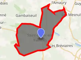
| |
 Saint-Léger-en-Yvelines  Saint-Léger-en-Yvelines | |
| Coordinates: 48°43′20″N 1°45′59″E | |
| Country | France |
| Region | Île-de-France |
| Department | Yvelines |
| Arrondissement | Rambouillet |
| Canton | Rambouillet |
| Government | |
| • Mayor (2008–2014) | Jean-Pierre Ghibaudo |
| Area 1 | 34.52 km2 (13.33 sq mi) |
| Population (2017-01-01)[1] | 1,378 |
| • Density | 40/km2 (100/sq mi) |
| Time zone | UTC+01:00 (CET) |
| • Summer (DST) | UTC+02:00 (CEST) |
| INSEE/Postal code | 78562 /78610 |
| Elevation | 112–186 m (367–610 ft) (avg. 150 m or 490 ft) |
| 1 French Land Register data, which excludes lakes, ponds, glaciers > 1 km2 (0.386 sq mi or 247 acres) and river estuaries. | |
Site
The district of Saint-Léger-en-Yvelines is in the centre of the department and in the heart of the Forest of Rambouillet. Rambouillet itself, the administrative centre of the arrondissement, is some 11 km (6.8 mi) to the south-east, and the prefecture, Versailles, is 37 km (23 mi) to the north-east.
The district is a rural one, and 94% of the unbuilt area is covered by forest, complemented by some cultivated clearings, primarily to the south of the village.
See also
References
- "Populations légales 2017". INSEE. Retrieved 6 January 2020.
| Wikimedia Commons has media related to Saint-Léger-en-Yvelines. |
| Authority control |
|---|
This article is issued from Wikipedia. The text is licensed under Creative Commons - Attribution - Sharealike. Additional terms may apply for the media files.