Poigny-la-Forêt
Poigny-la-Forêt is a commune in the Yvelines department in the Île-de-France in north-central France.
Poigny-la-Forêt | |
|---|---|
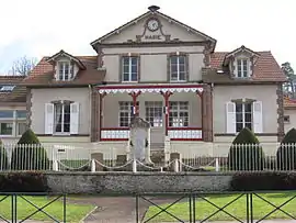 The town hall and school in Poigny-la-Forêt | |
Location of Poigny-la-Forêt 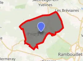
| |
 Poigny-la-Forêt  Poigny-la-Forêt | |
| Coordinates: 48°40′43″N 1°45′16″E | |
| Country | France |
| Region | Île-de-France |
| Department | Yvelines |
| Arrondissement | Rambouillet |
| Canton | Rambouillet |
| Government | |
| • Mayor (2020–2026) | Thierry Convert |
| Area 1 | 23.27 km2 (8.98 sq mi) |
| Population (2017-01-01)[1] | 931 |
| • Density | 40/km2 (100/sq mi) |
| Time zone | UTC+01:00 (CET) |
| • Summer (DST) | UTC+02:00 (CEST) |
| INSEE/Postal code | 78497 /78125 |
| Elevation | 132–179 m (433–587 ft) (avg. 160 m or 520 ft) |
| 1 French Land Register data, which excludes lakes, ponds, glaciers > 1 km2 (0.386 sq mi or 247 acres) and river estuaries. | |
History
The name of the town comes from the Celtic word Pugneis meaning "clearing in the woods."
In the twelfth century, the Order of Grandmont (Haute-Vienne) founded the priory of Notre-Dame-des-Moulineaux. In 1317, following the reorganization of the Order, it became part of Ouye (see Dourdan). In 1576, the family of Angennes Poigny who ruled, built a castle. From 1643 the site has been in disrepair. Today, you can still see the choir of the church and the remains of the wall along the D107 near the rocks Angennes.
Demographics
In 2017, Poigny-la-Forêt had 931 inhabitants, down from 1,014 in 2007.[2]
See also
References
- "Populations légales 2017". INSEE. Retrieved 6 January 2020.
- Population en historique depuis 1968, INSEE
| Wikimedia Commons has media related to Poigny-la-Forêt. |
| Authority control |
|---|
This article is issued from Wikipedia. The text is licensed under Creative Commons - Attribution - Sharealike. Additional terms may apply for the media files.