La Chapelle-Heulin
La Chapelle-Heulin is a commune in the Loire-Atlantique department in western France.
La Chapelle-Heulin | |
|---|---|
Commune | |
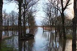 Flooded Port of the Montru in February 2014 | |
.svg.png.webp) Coat of arms | |
Location of La Chapelle-Heulin 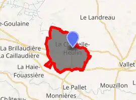
| |
 La Chapelle-Heulin  La Chapelle-Heulin | |
| Coordinates: 47°10′38″N 1°20′21″W | |
| Country | France |
| Region | Pays de la Loire |
| Department | Loire-Atlantique |
| Arrondissement | Nantes |
| Canton | Vallet |
| Intercommunality | Vallet |
| Government | |
| • Mayor (2020–2026) | Alain Arraitz |
| Area 1 | 13.47 km2 (5.20 sq mi) |
| Population (2017-01-01)[1] | 3,263 |
| • Density | 240/km2 (630/sq mi) |
| Time zone | UTC+01:00 (CET) |
| • Summer (DST) | UTC+02:00 (CEST) |
| INSEE/Postal code | 44032 /44330 |
| Elevation | 2–37 m (6.6–121.4 ft) |
| 1 French Land Register data, which excludes lakes, ponds, glaciers > 1 km2 (0.386 sq mi or 247 acres) and river estuaries. | |
Geography
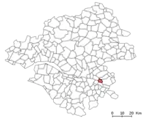
Location of La Chapelle-Heulin commune in the Loire-Atlantique Department
La Chapelle-Heulin is situated in 13,6702 miles east of Nantes, 19,8839 miles south of Ancenis and 26,719 miles west of Cholet. The neighbouring communes of La Chapelle-Heulin are Le Loroux-Bottereau, Le Landreau, Vallet, Le Pallet, La Haie-Fouassière and Haute-Goulaine.
Population
|
|
Personalities
- Aristide Briand, politician
References
- "Populations légales 2017". INSEE. Retrieved 6 January 2020.
| Wikimedia Commons has media related to La Chapelle-Heulin. |
| Authority control |
|
|---|
This article is issued from Wikipedia. The text is licensed under Creative Commons - Attribution - Sharealike. Additional terms may apply for the media files.