Rougé
Rougé (Breton: Ruzieg) is a commune in the Loire-Atlantique department in western France.
Rougé | |
|---|---|
Commune | |
 | |
.svg.png.webp) Coat of arms | |
Location of Rougé 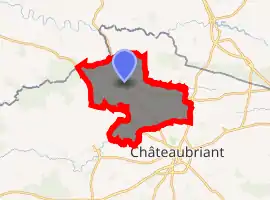
| |
 Rougé  Rougé | |
| Coordinates: 47°47′01″N 1°26′49″W | |
| Country | France |
| Region | Pays de la Loire |
| Department | Loire-Atlantique |
| Arrondissement | Châteaubriant-Ancenis |
| Canton | Châteaubriant |
| Intercommunality | Castelbriantais |
| Government | |
| • Mayor (2020–2026) | Jean-Michel Duclos |
| Area 1 | 56.32 km2 (21.75 sq mi) |
| Population (2017-01-01)[1] | 2,230 |
| • Density | 40/km2 (100/sq mi) |
| Time zone | UTC+01:00 (CET) |
| • Summer (DST) | UTC+02:00 (CEST) |
| INSEE/Postal code | 44146 /44660 |
| Elevation | 39–109 m (128–358 ft) |
| 1 French Land Register data, which excludes lakes, ponds, glaciers > 1 km2 (0.386 sq mi or 247 acres) and river estuaries. | |
It lies near Rennes.
The name "Rougé" comes from the Latin "Rubiacus", means the red place. The name was used to call "the red place" because of the high iron-composition of the ground.
Geography
The river Chère forms small part of the commune's southern border.
Population
| Year | Pop. | ±% |
|---|---|---|
| 1793 | 2,000 | — |
| 1806 | 2,083 | +4.2% |
| 1821 | 2,404 | +15.4% |
| 1831 | 2,295 | −4.5% |
| 1841 | 2,272 | −1.0% |
| 1851 | 2,710 | +19.3% |
| 1861 | 2,705 | −0.2% |
| 1872 | 2,813 | +4.0% |
| 1881 | 2,782 | −1.1% |
| 1891 | 2,895 | +4.1% |
| 1901 | 2,665 | −7.9% |
| 1911 | 2,625 | −1.5% |
| 1921 | 2,408 | −8.3% |
| 1931 | 2,249 | −6.6% |
| 1946 | 2,229 | −0.9% |
| 1954 | 2,179 | −2.2% |
| 1962 | 2,011 | −7.7% |
| 1968 | 1,995 | −0.8% |
| 1975 | 1,982 | −0.7% |
| 1982 | 2,055 | +3.7% |
| 1990 | 2,167 | +5.5% |
| 1999 | 2,141 | −1.2% |
| 2010 | 2,253 | +5.2% |
| 2017 | 2,230 | −1.0% |
References
- "Populations légales 2017". INSEE. Retrieved 6 January 2020.
See also
| Wikimedia Commons has media related to Rougé. |
| Authority control |
|---|
This article is issued from Wikipedia. The text is licensed under Creative Commons - Attribution - Sharealike. Additional terms may apply for the media files.