Saint-Aubin-des-Châteaux
Saint-Aubin-des-Châteaux is a commune in the Loire-Atlantique department in western France.
Saint-Aubin-des-Châteaux | |
|---|---|
Commune | |
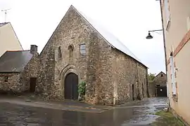 Chapel of the Templars | |
.svg.png.webp) Coat of arms | |
Location of Saint-Aubin-des-Châteaux 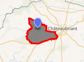
| |
 Saint-Aubin-des-Châteaux  Saint-Aubin-des-Châteaux | |
| Coordinates: 47°43′15″N 1°29′06″W | |
| Country | France |
| Region | Pays de la Loire |
| Department | Loire-Atlantique |
| Arrondissement | Châteaubriant-Ancenis |
| Canton | Châteaubriant |
| Intercommunality | Castelbriantais |
| Government | |
| • Mayor (2020–2026) | Daniel Rabu |
| Area 1 | 47.56 km2 (18.36 sq mi) |
| Population (2017-01-01)[1] | 1,795 |
| • Density | 38/km2 (98/sq mi) |
| Time zone | UTC+01:00 (CET) |
| • Summer (DST) | UTC+02:00 (CEST) |
| INSEE/Postal code | 44153 /44110 |
| Elevation | 32–92 m (105–302 ft) (avg. 65 m or 213 ft) |
| 1 French Land Register data, which excludes lakes, ponds, glaciers > 1 km2 (0.386 sq mi or 247 acres) and river estuaries. | |
Geography
The village is located in the northwestern part of the commune on the right bank of the river Chère, which flows southwest through the commune.
Population
| Year | Pop. | ±% |
|---|---|---|
| 1793 | 1,551 | — |
| 1806 | 1,377 | −11.2% |
| 1821 | 1,771 | +28.6% |
| 1831 | 1,810 | +2.2% |
| 1841 | 1,883 | +4.0% |
| 1851 | 2,062 | +9.5% |
| 1861 | 2,152 | +4.4% |
| 1872 | 2,204 | +2.4% |
| 1881 | 2,223 | +0.9% |
| 1891 | 2,403 | +8.1% |
| 1901 | 2,416 | +0.5% |
| 1911 | 2,277 | −5.8% |
| 1921 | 2,027 | −11.0% |
| 1931 | 1,830 | −9.7% |
| 1946 | 1,682 | −8.1% |
| 1954 | 1,587 | −5.6% |
| 1962 | 1,520 | −4.2% |
| 1968 | 1,472 | −3.2% |
| 1975 | 1,387 | −5.8% |
| 1982 | 1,351 | −2.6% |
| 1990 | 1,346 | −0.4% |
| 1999 | 1,314 | −2.4% |
| 2010 | 1,615 | +22.9% |
| 2017 | 1,795 | +11.1% |
References
- "Populations légales 2017". INSEE. Retrieved 6 January 2020.
| Wikimedia Commons has media related to Saint-Aubin-des-Châteaux. |
| Authority control |
|---|
This article is issued from Wikipedia. The text is licensed under Creative Commons - Attribution - Sharealike. Additional terms may apply for the media files.