Lake Elmo, Minnesota
Lake Elmo is a city in Washington County, Minnesota, United States. The population was 8,069 at the 2010 census.[6]
Lake Elmo | |
|---|---|
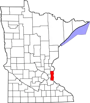
 Location of the city of Lake Elmo within Washington County, Minnesota | |
| Coordinates: 44°59′56″N 92°54′34″W | |
| Country | United States |
| State | Minnesota |
| County | Washington |
| Area | |
| • Total | 24.21 sq mi (62.69 km2) |
| • Land | 22.10 sq mi (57.25 km2) |
| • Water | 2.10 sq mi (5.44 km2) |
| Elevation | 912 ft (278 m) |
| Population | |
| • Total | 8,069 |
| • Estimate (2019)[3] | 9,210 |
| • Density | 416.67/sq mi (160.88/km2) |
| Time zone | UTC-6 (Central (CST)) |
| • Summer (DST) | UTC-5 (CDT) |
| ZIP code | 55042 |
| Area code(s) | 651 |
| FIPS code | 27-34244[4] |
| GNIS feature ID | 0646344[5] |
| Website | www.lakeelmo.org |
Much of the area within the city limits is still farmland, giving the city a rural appearance. However, the city density is likely to increase substantially over the next 15 years, due to a new city plan ordered following loss of a lawsuit against the Metropolitan Council, a regional planning authority.
History
The city took its name from nearby Lake Elmo.[7] Lake Elmo began with one farm in 1852 on the southwest corner of the intersection of what is now Manning Avenue and 30th Street, just southeast of downtown Lake Elmo and across the highway from the Lake Elmo Airport (FAA LID: 21D). The barn was originally built in 1875 and restored in 1998 as a house. The 1852 farmhouse was intentionally burned down in March 2007.[8]
Government
Lake Elmo has a City Council that consists of a Mayor and four council members. The City Council has the legislative authority and determines all matters of policy. The Mayor and council members are elected to serve a four-year term.[9] The city also has a park commission and a planning commission. The park commission is there to advise the City Council on issues regarding the development, improvement and maintenance of the city's parks and trails. The planning commission is there to make recommendations regarding the Comprehensive Plan and amendments to the plan, site plans, subdivisions, conditional use permits, planning, zoning and sign regulations, open space preservation developments, and other planning related items.[10]
The members include:
Mayor – Mike Pearson [9]
Council members – Justin Bloyer, Christine Nelson, Dale Dorschner, Lisa McGinn [9]
Planning Commission Members – Charles Cadenhead (Chair), Jeff Holtz, Jordan Graen, Kyle Risner, Brian Steil, Kathy Weeks, Brandon Mueller [9]
Park Commission Members – John Ames, Jean Olinger, Barry Weeks, John Mayek, Isak Nightingale, Steve Schumacher [9]
Geography
According to the United States Census Bureau, the city has a total area of 24.36 square miles (63.09 km2); 22.25 square miles (57.63 km2) is land and 2.11 square miles (5.46 km2) is water.[11]
Minnesota State Highway 36 runs east–west along Lake Elmo's northern boundary line. Interstate 94 runs east–west along Lake Elmo's southern boundary line. County State-Aid Highway 14 serves as the main east-west route, while County State-Aid Highway 17 serves as the main north-south route.
Demographics
| Historical population | |||
|---|---|---|---|
| Census | Pop. | %± | |
| 1930 | 218 | — | |
| 1940 | 265 | 21.6% | |
| 1950 | 386 | 45.7% | |
| 1960 | 550 | 42.5% | |
| 1970 | 3,565 | 548.2% | |
| 1980 | 5,296 | 48.6% | |
| 1990 | 5,903 | 11.5% | |
| 2000 | 6,863 | 16.3% | |
| 2010 | 8,069 | 17.6% | |
| 2019 (est.) | 9,210 | [3] | 14.1% |
| U.S. Decennial Census | |||
2010 census
As of the census[2] of 2010, there were 8,069 people, 2,779 households, and 2,252 families living in the city. The population density was 362.7 inhabitants per square mile (140.0/km2). There were 2,877 housing units at an average density of 129.3 per square mile (49.9/km2). The racial makeup of the city was 92.3% White, 0.8% African American, 0.3% Native American, 3.3% Asian, 1.3% from other races, and 1.9% from two or more races. Hispanic or Latino of any race were 3.5% of the population.
There were 2,779 households, of which 38.0% had children under the age of 18 living with them, 70.7% were married couples living together, 6.8% had a female householder with no husband present, 3.6% had a male householder with no wife present, and 19.0% were non-families. 14.9% of all households were made up of individuals, and 4.6% had someone living alone who was 65 years of age or older. The average household size was 2.88 and the average family size was 3.21.
The median age in the city was 42.4 years. 27.1% of residents were under the age of 18; 6.3% were between the ages of 18 and 24; 20.9% were from 25 to 44; 34.6% were from 45 to 64; and 11% were 65 years of age or older. The gender makeup of the city was 50.2% male and 49.8% female.
2000 census
As of the census[4] of 2000, there were 6,863 people, 2,347 households, and 1,924 families living in the city. The population density was 300.4 people per square mile (116.0/km2). There were 2,389 housing units at an average density of 104.6 per square mile (40.4/km2). The racial makeup of the city was 95.82% White, 0.38% African American, 0.29% Native American, 1.75% Asian, 0.54% from other races, and 1.22% from two or more races. Hispanic or Latino of any race were 1.31% of the population.
There were 2,347 households, out of which 41.6% had children under the age of 18 living with them, 69.4% were married couples living together, 7.8% had a female householder with no husband present, and 18.0% were non-families. 13.1% of all households were made up of individuals, and 3.3% had someone living alone who was 65 years of age or older. The average household size was 2.91 and the average family size was 3.19.
The population had 29.2% under the age of 18, 7.2% from 18 to 24, 29.3% from 25 to 44, 27.3% from 45 to 64, and 7.0% who were 65 years of age or older. The median age was 37 years. For every 100 females, there were 102.7 males. For every 100 females age 18 and over, there were 101.9 males.
The median income for a household in the city was $76,876, and the median income for a family was $84,562. Males had a median income of $56,667 versus $32,564 for females. The per capita income for the city was $33,007. About 4.8% of families and 7.3% of the population were below the poverty line, including 12.6% of those under age 18 and 2.3% of those age 65 or over.
Education
Most of Lake Elmo is part of the Stillwater School District (#834), and is home to Lake Elmo Elementary School and Oak-Land Jr. High School. This encapsulates the prestigious St. Croix Preparatory school which is known as one of the highest ranking schools in Minnesota, which offers students the opportunity to prepare for an educational success after high school.
Rasmussen College–Lake Elmo / Woodbury campus is located in Lake Elmo and serves students in the surrounding areas. Rasmussen College is a career focused, regionally accredited college that offers bachelor and associate degree programs. Rasmussen college concentrates on programs in the following areas: health sciences, nursing, criminal justice, technology and design, business, and early education.
Baytown Township Groundwater Plume
The primary source area for the Baytown Township Groundwater Plume Contamination Superfund site is a property located at 11325 Stillwater Boulevard in Lake Elmo. The property was used by a metal-working facility from 1940 to 1968. The site is listed as a superfund site due to TCE contamination of a groundwater aquifer used for local drinking water supplies.
See also
References
- "2019 U.S. Gazetteer Files". United States Census Bureau. Retrieved July 26, 2020.
- "U.S. Census website". United States Census Bureau. Retrieved 2012-11-13.
- "Population and Housing Unit Estimates". United States Census Bureau. May 24, 2020. Retrieved May 27, 2020.
- "U.S. Census website". United States Census Bureau. Retrieved 2008-01-31.
- "US Board on Geographic Names". United States Geological Survey. 2007-10-25. Retrieved 2008-01-31.
- "2010 Census Redistricting Data (Public Law 94-171) Summary File". American FactFinder. U.S. Census Bureau, 2010 Census. Retrieved 23 April 2011.
- Chicago and North Western Railway Company (1908). A History of the Origin of the Place Names Connected with the Chicago & North Western and Chicago, St. Paul, Minneapolis & Omaha Railways. p. 180.
- Andrew Wallmeyer (26 March 2007). "Burning down the house". Stillwater Gazette. Retrieved 31 August 2010.
- "City Of Lake ElmoCity Council". Lakeelmo.org. Retrieved 2017-10-29.
- "City Of Lake ElmoCommissions & Committees". Lakeelmo.org. Retrieved 2017-10-29.
- "US Gazetteer files 2010". United States Census Bureau. Archived from the original on 2012-07-02. Retrieved 2012-11-13.
External links
Municipalities and communities of Washington County, Minnesota, United States | ||
|---|---|---|
| Cities |
|  Map of Minnesota highlighting Washington County |
| Townships | ||
| Unincorporated communities | ||
| Ghost towns/Neighborhoods | ||
| Footnotes | ‡This populated place also has portions in an adjacent county or counties | |
| ||
| Authority control |
|---|