St. Paul Park, Minnesota
St. Paul Park is a city in Washington County, Minnesota, United States. The population was 5,279 at the 2010 census.[7] It is on the east bank of the Mississippi River, five miles (8 km) downstream from St. Paul.
St. Paul Park | |
|---|---|
| Motto(s): "On The Mississippi"[1] | |
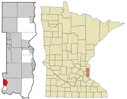 Location of the city of St. Paul Park within Washington County, Minnesota | |
| Coordinates: 44°50′22″N 92°59′30″W | |
| Country | United States |
| State | Minnesota |
| County | Washington |
| Government | |
| • Type | Democracy |
| • Mayor | Sandi Dingle |
| Area | |
| • Total | 3.56 sq mi (9.21 km2) |
| • Land | 2.97 sq mi (7.69 km2) |
| • Water | 0.59 sq mi (1.52 km2) |
| Elevation | 784 ft (239 m) |
| Population | |
| • Total | 5,279 |
| • Estimate (2019)[4] | 5,362 |
| • Density | 1,806.00/sq mi (697.30/km2) |
| Time zone | UTC-6 (Central (CST)) |
| • Summer (DST) | UTC-5 (CDT) |
| ZIP code | 55071 |
| Area code(s) | 651 |
| FIPS code | 27-58018[5] |
| GNIS feature ID | 0650970[6] |
| Website | www.stpaulpark.govoffice.com |
Geography
According to the United States Census Bureau, the city has a total area of 3.58 square miles (9.27 km2); 2.99 square miles (7.74 km2) is land and 0.59 square miles (1.53 km2) is water.[8]
U.S. Highway 61 and U.S. Highway 10, which run concurrently through the town, serves as a main route in the community.
St. Paul Park is bordered by Cottage Grove to the east and Newport to the north.
Economy
The town is home to the St. Paul Park Refinery, owned by Marathon Petroleum, which produces 106,500 barrels per day (“bpd”).[9]
Education
High School students living in St. Paul Park attend Park High School. Middle School students attend Oltman Middle School. Elementary School students attend Pullman Elementary School.
Demographics
| Historical population | |||
|---|---|---|---|
| Census | Pop. | %± | |
| 1890 | 1,173 | — | |
| 1910 | 832 | — | |
| 1920 | 900 | 8.2% | |
| 1930 | 982 | 9.1% | |
| 1940 | 1,096 | 11.6% | |
| 1950 | 2,438 | 122.4% | |
| 1960 | 3,267 | 34.0% | |
| 1970 | 5,587 | 71.0% | |
| 1980 | 4,864 | −12.9% | |
| 1990 | 4,965 | 2.1% | |
| 2000 | 5,070 | 2.1% | |
| 2010 | 5,279 | 4.1% | |
| 2019 (est.) | 5,362 | [4] | 1.6% |
| U.S. Decennial Census[10] | |||
2010 census
As of the census[3] of 2010, there were 5,279 people, 1,970 households, and 1,381 families residing in the city. The population density was 1,765.6 inhabitants per square mile (681.7/km2). There were 2,079 housing units at an average density of 695.3 per square mile (268.5/km2). The racial makeup of the city was 88.5% White, 3.3% African American, 0.5% Native American, 3.7% Asian, 1.9% from other races, and 2.1% from two or more races. Hispanic or Latino of any race were 6.3% of the population.
There were 1,970 households, of which 36.6% had children under the age of 18 living with them, 49.9% were married couples living together, 14.9% had a female householder with no husband present, 5.3% had a male householder with no wife present, and 29.9% were non-families. 21.7% of all households were made up of individuals, and 7.2% had someone living alone who was 65 years of age or older. The average household size was 2.66 and the average family size was 3.11.
The median age in the city was 34.3 years. 25.6% of residents were under the age of 18; 8.8% were between the ages of 18 and 24; 29.5% were from 25 to 44; 26.3% were from 45 to 64; and 9.9% were 65 years of age or older. The gender makeup of the city was 50.2% male and 49.8% female.
2000 census
As of the census[5] of 2000, there were 5,070 people, 1,829 households, and 1,344 families residing in the city. The population density was 2,131.6 people per square mile (822.5/km2). There were 1,868 housing units at an average density of 785.4 per square mile (303.0/km2). The racial makeup of the city was 93.87% White, 2.27% African American, 0.34% Native American, 1.10% Asian, 0.04% Pacific Islander, 0.99% from other races, and 1.40% from two or more races. Hispanic or Latino of any race were 2.78% of the population.
There were 1,829 households, out of which 38.1% had children under the age of 18 living with them, 55.7% were married couples living together, 12.5% had a female householder with no husband present, and 26.5% were non-families. 20.9% of all households were made up of individuals, and 6.3% had someone living alone who was 65 years of age or older. The average household size was 2.74 and the average family size was 3.17.
In the city, the population was spread out, with 29.1% under the age of 18, 8.1% from 18 to 24, 33.5% from 25 to 44, 19.7% from 45 to 64, and 9.6% who were 65 years of age or older. The median age was 34 years. For every 100 females, there were 98.6 males. For every 100 females age 18 and over, there were 97.9 males.
The median income for a household in the city was $50,805, and the median income for a family was $54,063. Males had a median income of $37,083 versus $29,143 for females. The per capita income for the city was $20,234. About 5.1% of families and 5.5% of the population were below the poverty line, including 7.6% of those under age 18 and 3.6% of those age 65 or over.
Notable people
- Dallas Holm, Christian singer/songwriter; born and raised in St. Paul Park.
- Dale Arnold, Bowdoin College alumnus. Co-Host of the WEEI-FM afternoon drive Dale & Holley with Keefe Show and NESN Pre and Post Game host for the Boston Bruins, lived in St. Paul Park before moving back to Maine.
References
- "City of St. Paul Park". City of St. Paul Park. Retrieved October 8, 2012.
- "2019 U.S. Gazetteer Files". United States Census Bureau. Retrieved July 26, 2020.
- "U.S. Census website". United States Census Bureau. Retrieved 2012-11-13.
- "Population and Housing Unit Estimates". United States Census Bureau. May 24, 2020. Retrieved May 27, 2020.
- "U.S. Census website". United States Census Bureau. Retrieved 2008-01-31.
- "US Board on Geographic Names". United States Geological Survey. 2007-10-25. Retrieved 2008-01-31.
- "2010 Census Redistricting Data (Public Law 94-171) Summary File". American FactFinder. U.S. Census Bureau, 2010 Census. Retrieved 23 April 2011.
- "US Gazetteer files 2010". United States Census Bureau. Archived from the original on 2012-01-25. Retrieved 2012-11-13.
- "The St. Paul Park Refinery". Western Refining. Retrieved 2016-08-30.
- "Census of Population and Housing". Census.gov. Retrieved June 4, 2015.
External links
Municipalities and communities of Washington County, Minnesota, United States | ||
|---|---|---|
| Cities |
| 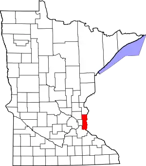 Map of Minnesota highlighting Washington County |
| Townships | ||
| Unincorporated communities | ||
| Ghost towns/Neighborhoods | ||
| Footnotes | ‡This populated place also has portions in an adjacent county or counties | |
| ||
| Authority control |
|---|