Woodbury, Minnesota
Woodbury is a city in Washington County, Minnesota, United States, and part of the Minneapolis–Saint Paul metropolitan area. Woodbury is situated east of Saint Paul along Interstate 94. The 2019 population for Woodbury was 72,828, making it the ninth most populous city in Minnesota.[6]
City of Woodbury | |
|---|---|
.jpg.webp) Woodbury City Hall in October 2008 | |
 Flag Seal | |
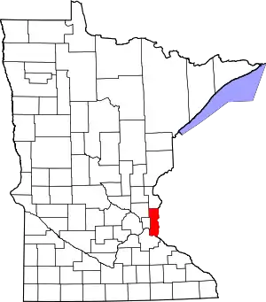
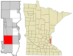 Location of the city of Woodbury within Washington County, Minnesota | |
| Coordinates: 44°55′08″N 92°56′12″W | |
| Country | United States |
| State | Minnesota |
| County | Washington |
| Incorporated | 1967 |
| Government | |
| • Type | Mayor–council government |
| • Mayor | Anne Burt[1] |
| Area | |
| • City | 35.72 sq mi (92.52 km2) |
| • Land | 34.89 sq mi (90.38 km2) |
| • Water | 0.83 sq mi (2.14 km2) 2.33% |
| Elevation | 1,063 ft (302 m) |
| Population | |
| • City | 61,961 |
| • Estimate (2019)[4] | 72,828 |
| • Rank | US: 506th MN: 9th |
| • Density | 2,087.12/sq mi (805.84/km2) |
| • Metro | 3,629,190 (US: 16th) |
| Time zone | UTC−6 |
| • Summer (DST) | UTC−5 (CDT) |
| ZIP codes | 55125, 55129 |
| Area code(s) | 651 |
| FIPS code | 27-71428 |
| GNIS feature ID | 0659734[5] |
| Website | ci.woodbury.mn.us |
History
At almost 36 square miles in size, Woodbury is a direct descendant of one of the congressional townships that Minnesota Territory was divided into when the territory was ceded by the Native Americans of the United States and "opened to settlement." Woodbury was originally named Red Rock, but was renamed Woodbury after Levi Woodbury, the first justice of the Supreme Court of the United States to attend law school, after it was realized that another Red Rock Township existed in Minnesota.[7] When first settled in 1844, the land was mostly wood but was converted to farmland. The township government was organized in 1858.[8] One of the city's few surviving 19th-century farms, the Charles Spangenberg Farmstead, is listed on the National Register of Historic Places.[9]
In 1955, the first suburban development broke ground in Woodbury: Woodbury Heights.[10] After some years of growth, the town government could not adequately provide services for new developments, and it became clear that Woodbury needed the government of a village with extra privileges. The earliest proposal for incorporation officially came in 1963 after two years of debate.
The Minnesota Municipal Commission had recently found that the fragmented way in which the Minneapolis suburbs and the suburbs around White Bear Lake had developed was disadvantageous, as it made coordinating sewers, public water systems, and other amenities difficult. Thus, the Commission had been encouraging towns to incorporate in full whenever possible.
Since 1961, the Town of Cottage Grove had been petitioning to become a village, and the Minnesota Municipal Commission took it upon themselves to push for a joint incorporation of Woodbury and Cottage Grove as the Village of Washington. The idea was agreed upon by the two town commissions, and the issue was put up for a vote during the general election of 1963. It lost with 662 votes for joint incorporation, and 1,284 against. Cottage Grove would later incorporate on its own in 1965.[11] [12]
In 1966, a series of meetings took place setting up the incorporation of the Village of Woodbury. A vote was conducted on February 14, 1967, with 543 voting for incorporation, and 164 against. The Village was officially incorporated on March 7, 1967.[13]
Geography
According to the United States Census Bureau, the city has a total area of 35.56 square miles (92.10 km2), of which 34.73 square miles (89.95 km2) is land and 0.83 square miles (2.15 km2) is water.[14]
The city is bounded on the northern side by Interstate 94, the south by the plane of 60th Street South, the west by Century Avenue, and the east by Manning Avenue. The adjoining cities in these directions are, respectively, Oakdale, Landfall, Lake Elmo, Cottage Grove, Maplewood, Newport and Afton.
Woodbury is composed of upland between the valleys of the Mississippi River and St. Croix River. The northeast corner of Woodbury lies within the watershed of Valley Creek, one of the few remaining trout streams in the Twin Cities area. Valley Creek flows eastwards to the St. Croix River at Afton, Minnesota. The city also contains several small lakes, including Powers, Wilmes, Colby, Carver, and Battle Creek. Battle Creek lake is the source of Battle Creek, which flows westwards to the Mississippi River in Saint Paul.
Climate
| Climate data for Woodbury, Minnesota | |||||||||||||
|---|---|---|---|---|---|---|---|---|---|---|---|---|---|
| Month | Jan | Feb | Mar | Apr | May | Jun | Jul | Aug | Sep | Oct | Nov | Dec | Year |
| Average high °F (°C) | 23 (−5) |
30 (−1) |
42 (6) |
58 (14) |
71 (22) |
79 (26) |
83 (28) |
81 (27) |
72 (22) |
59 (15) |
41 (5) |
27 (−3) |
55.5 (13.1) |
| Average low °F (°C) | 6 (−14) |
13 (−11) |
24 (−4) |
36 (2) |
48 (9) |
58 (14) |
63 (17) |
61 (16) |
52 (11) |
40 (4) |
26 (−3) |
12 (−11) |
36.6 (2.6) |
| Average precipitation inches (mm) | 1.02 (26) |
0.78 (20) |
1.92 (49) |
2.54 (65) |
3.73 (95) |
4.98 (126) |
4.41 (112) |
4.37 (111) |
3.20 (81) |
2.51 (64) |
2.09 (53) |
1.04 (26) |
32.59 (828) |
| Source: http://www.weather.com/outlook/health/fitness/wxclimatology/monthly/graph/USMN0831 | |||||||||||||
Government and politics
| Year | Republican | Democratic | Third parties |
|---|---|---|---|
| 2020 | 38.5% 17,670 | 59.4% 27,263 | 2.1% 964 |
| 2016 | 39.9% 15,286 | 51.7% 19,819 | 8.4% 3,200 |
| 2012 | 48.5% 17,785 | 49.8% 18,252 | 1.7% 618 |
| 2008 | 46.3% 15,856 | 52.5% 17,968 | 1.1% 391 |
| 2004 | 54.6% 20,204 | 44.6% 16,486 | 0.8% 310 |
| 2000 | 52.1% 13,539 | 43.6% 11,319 | 4.3% 1,117 |
| 1996 | 40.6% 7,156 | 48.6% 8,577 | 10.8% 1,905 |
| 1992 | 36.6% 5,088 | 39.7% 5,510 | 23.7% 3,293 |
| 1988 | 51.1% 4,836 | 47.2% 4,466 | 1.6% 153 |
| 1984 | 56.2% 3,893 | 42.1% 2,917 | 1.7% 118 |
| 1980 | 45.7% 2,493 | 40.2% 2,196 | 14.1% 771 |
| 1976 | 51.7% 2,160 | 45.3% 1,895 | 3.0% 124 |
| 1972 | Unknown | Unknown | Unknown |
| 1968 | 43.1% 875 | 53.2% 1,080 | 3.6% 74 |
| 1964 | 31.6% 398 | 68.3% 860 | 0.1% 1 |
| 1960 | 48.6% 587 | 51.0% 617 | 0.4% 5 |
| 1956 | 57.2% 267 | 42.4% 198 | 0.4% 2 |
| Year | Republican | Democratic | Third parties |
|---|---|---|---|
| 2018 | 41.4% 14,422 | 56.0% 19,516 | 2.6% 906 |
| 2014 | 49.4% 11,851 | 47.1% 11,302 | 3.5% 836 |
| 2010 | 48.1% 12,509 | 38.5% 10,023 | 13.4% 3,488 |
| 2006 | 57.5% 18,363 | 35.7% 11,403 | 6.8% 2,180 |
| 2002 | 58.0% 16,841 | 29.6% 8,595 | 12.5% 3,625 |
| 1998 | 45.0% 8,876 | 22.2% 4,391 | 32.8% 6,468 |
| 1994 | 73.4% 9,459 | 22.2% 2,856 | 4.4% 569 |
| 1990 | 63.9% 5,972 | 31.4% 2,942 | 4.7% 438 |
| 1986 | 52.5% 2,380 | 43.4% 1,966 | 4.1% 185 |
| 1982 | 54.5% 2,956 | 42.7% 2,314 | 2.8% 152 |
| 1978 | 68.5% 2,592 | 30.0% 1,136 | 1.5% 55 |
| 1974 | Unknown | Unknown | Unknown |
| 1970 | 49.1% 959 | 50.8% 993 | 0.1% 1 |
| 1966 | 53.6% 762 | 46.0% 654 | 0.4% 6 |
| 1962 | 45.3% 426 | 53.9% 507 | 0.7% 7 |
| 1960 | 45.3% 551 | 54.5% 663 | 0.2% 2 |
| 1958 | 44.5% 257 | 55.0% 318 | 0.5% 3 |
| 1956 | 55.2% 274 | 43.8% 217 | 1.0% 5 |
| 1954 | 55.7% 195 | 44.0% 154 | 0.3% 1 |
| 1952 | 68.4% 336 | 31.4% 154 | 0.2% 1 |
| 1950 | 66.8% 211 | 32.6% 103 | 0.6% 2 |
| 1948 | 63.1% 265 | 36.0% 151 | 1.0% 4 |
| 1946 | 77.6% 180 | 21.1% 49 | 1.3% 3 |
| 1944 | 85.9% 352 | 13.7% 56 | 0.5% 2 |
| 1942 | 52.7% 146 | 45.1% 125 | 2.2% 6 |
| 1940 | 64.8% 289 | 7.4% 33 | 27.8% 124 |
| 1938 | 84.3% 348 | 2.2% 9 | 13.6% 56 |
| 1936 | 48.6% 197 | No candidate | 51.4% 208 |
| 1934 | 43.1% 150 | 10.3% 36 | 46.6% 162 |
| 1932 | 23.6% 90 | 11.3% 43 | 65.2% 249 |
| 1930 | 26.8% 67 | 2.8% 7 | 70.4% 176 |
| 1928 | 67.9% 237 | 11.5% 40 | 20.6% 72 |
| 1926 | 60.0% 120 | 0.5% 1 | 39.5% 79 |
| 1924 | 28.6% 78 | 1.1% 3 | 70.3% 192 |
| 1922 | 19.3% 46 | 4.2% 10 | 76.5% 182 |
| 1920 | 21.0% 71 | 4.1% 14 | 74.9% 253 |
| 1918 | 8.3% 15 | 5.5% 10 | 86.2% 156 |
| 1916 | 82.3% 107 | 10.8% 14 | 6.9% 9 |
| 1914 | 47.8% 64 | 44.8% 60 | 7.5% 10 |
| 1912 | 61.5% 107 | 14.9% 26 | 23.6% 41 |
| 1910 | 85.5% 96 | 13.9% 16 | 2.6% 3 |
| 1908 | 54.0% 81 | 42.7% 64 | 3.3% 5 |
| 1906 | 55.2% 32 | 44.8% 26 | 0.0% 0 |
| 1904 | 72.8% 83 | 26.3% 30 | 0.9% 1 |
| 1902 | 71.0% 88 | 28.2% 35 | 0.8% 1 |
| 1900 | 52.2% 96 | 45.7% 84 | 2.2% 4 |
| 1898 | 75.2% 103 | 21.9% 30 | 2.9% 4 |
| 1896 | 66.7% 146 | 32.4% 71 | 0.9% 2 |
| 1894 | 60.1% 125 | 26.4% 55 | 13.5% 28 |
| 1892 | 47.1% 89 | 37.0% 70 | 15.9% 30 |
| 1890 | 46.1% 89 | 51.3% 99 | 2.6% 5 |
| 1888 | 49.1% 104 | 47.6% 101 | 3.3% 7 |
Economy
State Farm Insurance was a large-scale employer in the city, employing about 2,000 people in a building that opened in 1994.[17] In 2006 the multi-department facility was relocated to Lincoln, Nebraska, and the building remained vacant until it was demolished in 2015 for redevelopment.[17] There are also many smaller employers, such as the Joint Commission on Allied Health Personnel in Ophthalmology and offices for financial corporations. Many Woodbury residents are employed at 3M, whose headquarters are located a few miles west in Maplewood.
A large portion of the economy is retail. The two largest retail centers are Tamarack Village, near the intersection of Radio Drive and Interstate 94, and Woodbury Village, near the intersection of Valley Creek Road and Interstate 494. Woodbury Lakes, an upscale retail development with an open-air mall layout, was completed in 2005.
Largest employers
According to the city's 2015 Community Development Annual Report.[18]
| Rank | Employer | # of Employees |
|---|---|---|
| 1 | South Washington County Schools | 1,207 |
| 2 | Fairview/HealthEast | 860 |
| 3 | Summit Orthopedics | 604 |
| 4 | Walmart | 333 |
| 5 | Assurant | 315 |
| 6 | Jerry's Enterprises | 305 |
| 7 | Target | 288 |
| 8 | Woodbury Senior Living | 261 |
| 9 | City of Woodbury | 251 |
| 10 | Allina | 250 |
| 11 | Sam's Club | 218 |
| 12 | HealthPartners | 216 |
| 13 | Cabela's | 188 |
| 14 | Northern Tier Energy | 180 |
Other important employers include eFunds, Long Term Care Group and Dean Foods/Land O'Lakes.
Education
Most of Woodbury is located within the South Washington County School District, and the majority of high school students attend either Woodbury High School or East Ridge High School. However, small portions of the city attend Tartan Senior High School in Oakdale and Stillwater Area High School in Stillwater. Some students attend public or private schools in other school districts chosen by their families under Minnesota's open enrollment statute.[19]
In November 2006, School District 833 selected an 80-acre (320,000 m2) site for its third high school, later named East Ridge High School. The site lies between two city-owned properties south of Bailey Road and east of Radio Drive: the 80-acre (320,000 m2) HealthEast Sports Center and the Danner gravel pit. The city also owns an additional 80 acres (320,000 m2) south of the sports center to allow for expansion.[20] The new school opened in September 2009. The students attending this new high school came from Woodbury and nearby Cottage Grove, as well as the smaller towns of Newport, Afton, and Denmark.
There are two middle schools in Woodbury, Lake Middle School and Woodbury Middle School. Some middle school students also attend Oltman Middle School in Cottage Grove, Skyview Middle School in Oakdale, Maplewood Middle School in Maplewood, and Oak-Land Middle School in Lake Elmo. Along with these middle schools, Woodbury is also served by 12 elementary schools in three school districts.[21]
Woodbury is also home to the Minnesota Math and Science Academy, a charter school. Saint Ambrose of Woodbury is a Catholic school with Pre-K through 8th grade; and New Life Academy is a private Christian school and both are located within the city limits.
Rasmussen College–Lake Elmo / Woodbury campus serves students in the Woodbury area. Rasmussen College is a regionally accredited, career focused college that offeres bachelor and associate degree programs. Rasmussen College concentrates on programs in the following areas: health sciences, nursing, business, technology and design, criminal justice, and early education.[22]
Recreation
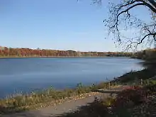
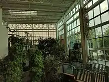
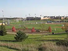
Woodbury contains 45 parks covering approximately 3,000 acres (12 km2) and approximately 100 miles (160 km) of trails. The trails, most of which are paved, connect many of the parks. Three of the largest parks encircle Colby, Wilmes, and Powers lakes, respectively. The indoor Central Park is adjacent to the public library. HealthEast Sports Center is the primary athletic location, including softball fields, baseball fields, soccer fields, football fields, sand volleyball courts, two indoor ice arenas, and 1 outdoor ice arena.
Two golf courses are located in the city: Prestwick (privately owned) and Eagle Valley (publicly owned). There are many local events year-round. A popular summer event named Woodbury Days is held in Ojibway Park each year. Woodbury Days includes a parade, carnival, live music, fireworks, and many booths for the city's shops, churches, and services. Woodbury Days is also known for its Taste of Woodbury tent located in the parking lot behind Woodbury High School and overlooking the Ojibway Park Band Shell. This tent includes many restaurants in the city. There's also an outdoor pool available by membership in the summer called Colby lake pool.
Demographics
| Historical population | |||
|---|---|---|---|
| Census | Pop. | %± | |
| 1860 | 350 | — | |
| 1870 | 990 | 182.9% | |
| 1880 | 1,169 | 18.1% | |
| 1890 | 1,166 | −0.3% | |
| 1900 | 1,200 | 2.9% | |
| 1910 | 1,039 | −13.4% | |
| 1920 | 956 | −8.0% | |
| 1930 | 931 | −2.6% | |
| 1940 | 955 | 2.6% | |
| 1950 | 1,056 | 10.6% | |
| 1960 | 3,014 | 185.4% | |
| 1970 | 6,184 | 105.2% | |
| 1980 | 10,297 | 66.5% | |
| 1990 | 20,075 | 95.0% | |
| 2000 | 46,463 | 131.4% | |
| 2010 | 61,961 | 33.4% | |
| 2019 (est.) | 72,828 | [4] | 17.5% |
| U.S. Decennial Census[23] 2018 Estimate[24] | |||
2010 census
As of the census[3] of 2010, there were 61,961 people, 22,594 households, and 16,688 families living in the city. The population density was 1,784.1 inhabitants per square mile (688.8/km2). There were 23,568 housing units at an average density of 678.6 per square mile (262.0/km2). The racial makeup of the city was 81.4% White, 5.6% African American, 0.3% Native American, 9.1% Asian, 1.0% from other races, and 2.5% from two or more races. Hispanic or Latino of any race were 3.8% of the population.
There were 22,594 households, of which 42.3% had children under the age of 18 living with them, 61.8% were married couples living together, 8.7% had a female householder with no husband present, 3.3% had a male householder with no wife present, and 26.1% were non-families. 20.4% of all households were made up of individuals, and 5.7% had someone living alone who was 65 years of age or older. The average household size was 2.73 and the average family size was 3.20.
The median age in the city was 35.6 years. 29.6% of residents were under the age of 18; 6.2% were between the ages of 18 and 24; 29.6% were from 25 to 44; 26.3% were from 45 to 64; and 8.3% were 65 years of age or older. The gender makeup of the city was 48.2% male and 51.8% female.
2000 census
As of the census of 2000, there were 46,463 people, 16,676 households, and 12,657 families living in the city. The population density was 1,327.7 people per square mile (512.6/km2). There were 17,541 housing units at an average density of 501.2 per square mile (193.5/km2). The racial makeup of the city was 90.04% White, 2.51% African American, 0.24% Native American, 5.01% Asian, 0.01% Pacific Islander, 0.62% from other races, and 1.56% from two or more races. Hispanic or Latino of any race were 2.14% of the population.
There were 16,676 households, out of which 43.8% had children under the age of 18 living with them, 66.8% were married couples living together, 6.9% had a female householder with no husband present, and 24.1% were non-families. 18.8% of all households were made up of individuals, and 3.3% had someone living alone who was 65 years of age or older. The average household size was 2.76 and the average family size was 3.20.
In the city, the population was spread out, with 30.6% under the age of 18, 5.9% from 18 to 24, 36.9% from 25 to 44, 20.5% from 45 to 64, and 6.1% who were 65 years of age or older. The median age was 33 years. For every 100 females, there were 94.1 males. For every 100 females age 18 and over, there were 91.4 males.
The median income for a household in the city was $76,109, and the median income for a family was $84,997. Males had a median income of $60,224 versus $37,676 for females. The per capita income for the city was $32,606. About 0.8% of families and 1.7% of the population were below the poverty line, including 1.2% of those under age 18 and 1.2% of those age 65 or over.
Notable people
- Kelly Fenton, former Minnesota State Representative and former Minnesota Republican Party deputy chairperson
- Susan Kent, Minnesota State Senate minority leader
- Jason Lewis, former United States Representative From Minnesota's Second Congressional District
- Sam King, Minnesota State silly pants 14 icee don’t hate
- Mary Giuliani Stephens, former mayor
References
- "MN Election Results". electionresults.sos.state.mn.us. Retrieved 2020-01-09.
- "2019 U.S. Gazetteer Files". United States Census Bureau. Retrieved July 26, 2020.
- "U.S. Census website". United States Census Bureau. Retrieved November 13, 2012.
- "Population and Housing Unit Estimates". United States Census Bureau. May 24, 2020. Retrieved May 27, 2020.
- "US Board on Geographic Names". United States Geological Survey. October 25, 2007. Retrieved January 31, 2008.
- "Minnesota State Demographic Center 2018 Estimates".
- http://www.ci.woodbury.mn.us/house-home-and-pets-sp/new-resident-information/history-woodbury
- Upham, Warren (1920). Minnesota Geographic Names: Their Origin and Historic Significance. Minnesota Historical Society. p. 571.
- Dabrowski, Mario (May 1, 1978). "National Register of Historic Places Inventory -- Nomination Form: Charles Spangenberg Farmstead". National Park Service. Retrieved December 16, 2013. Cite journal requires
|journal=(help) - "History". www.woodburymn.gov. Retrieved 2020-05-10.
- "Municipal Boundary Adjustment Docket | Municipal Boundary Adjustment". www.mba.state.mn.us. Retrieved 2020-05-10.
- Minnesota Municipal Commission (27 September 1963). In the Matter of the Application for the Incorporation of the Village to be known as the Village of Washington, Minnesota, Pursuant to Minnesota Statutes, 414.02 (PDF) (Report). St. Paul, Minnesota: Minnesota Office of Administrative Hearings. I-7. Retrieved 10 May 2020.
- Minnesota Municipal Commission (6 March 1967). In the Matter of the Petition for the Incorporation of the Village of Woodbury (PDF) (Report). St. Paul, Minnesota: Minnesota Office of Administrative Hearings. I-20. Retrieved 10 May 2020.
- "US Gazetteer files 2010". United States Census Bureau. Retrieved November 13, 2012.
- "Election Results - Minnesota Legislative Reference Library". www.leg.state.mn.us. Retrieved 2020-05-10.
- "Election Results - Minnesota Legislative Reference Library". www.leg.state.mn.us. Retrieved 2020-05-19.
- "Woodbury's giant State Farm building will be demolished". Star Tribune. October 30, 2015.
- http://www.ci.woodbury.mn.us/images/community-development-annual-report-2015.pdf
- "Open Enrollment". Minnesota Department of Education. Archived from the original on August 26, 2010. Retrieved November 19, 2010.
- "ISD 833 New High School/BSC - Process Update". Retrieved 9 February 2018.
- "Elementary Schools - South Washington County Schools". www.sowashco.org. Retrieved 9 February 2018.
- "College in Lake Elmo Woodbury, MN | Rasmussen College". Rasmussen College. Retrieved 10 May 2020.
- United States Census Bureau. "Census of Population and Housing". Retrieved July 14, 2014.
- "Population Estimates". United States Census Bureau. Retrieved July 14, 2019.
External links
| Wikivoyage has a travel guide for Woodbury. |
Municipalities and communities of Washington County, Minnesota, United States | ||
|---|---|---|
| Cities |
|  Map of Minnesota highlighting Washington County |
| Townships | ||
| Unincorporated communities | ||
| Ghost towns/Neighborhoods | ||
| Footnotes | ‡This populated place also has portions in an adjacent county or counties | |
| ||

| Authority control |
|---|