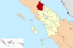
Langkat Regency
Langkat Regency (Indonesian: Kabupaten Langkat) is the northernmost regency of North Sumatra. Its seat is Stabat. Its area is 6,263.29 km2 and its population was 967,535 at the 2010 national Census;[2] at the 2015 Census this had risen to 1,012,739[3] and the latest official estimate (as for mid 2019) is 1,041,775.[4]
Langkat Regency
لڠكت | |
|---|---|
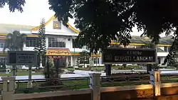 The Langkat regent's office | |
 Coat of arms | |
 | |
| Country | Indonesia |
| Province | North Sumatra |
| Regency seat | Stabat |
| Government | |
| • Regent | Terbit Rencana Perangin-Angin |
| • Vice Regent | Syah Afandin |
| • Chairman of Regency's Council of Representatives | Surialam (Golkar) |
| • Vice Chairmen of Regency's Council of Representatives | Donny Setha (Gerindra), Ralin Sinulingga (PDI-P) and Antoni Ginting (National Mandate Party) |
| Area | |
| • Total | 6,263.29 km2 (2,418.27 sq mi) |
| Population (2015)[1] | |
| • Total | 1,041,775 |
| • Density | 170/km2 (430/sq mi) |
| Time zone | UTC+7 (WIB) |
| Website | www |
Immediately to the south is Karo Regency, to the east is Deli Serdang Regency (which surrounds the city of Medan) and the city of Binjai (formerly part of Langkat Regency), to the north lies the Strait of Malacca and to the west lies Aceh Province.
Administrative districts
Langkat Regency is divided into twenty-three administrative districts (Indonesian: kecamatan), tabulated below with their areas and their populations at the 2010 Census,[2] together with the latest official estimates (for mid 2019).[5] The table also includes the number of administrative villages (rural desa and urban kelurahan) in each district and its post code.
| Name | Area in km2 | Pop'n Census 2010[2] | Pop'n Estimate mid 2019[6] | No. of vill. | Post code |
|---|---|---|---|---|---|
| Bohorok | 1,101.83 | 39,851 | 42,878 | 19 | 20774 |
| Serapit | 98.50 | 15,908 | 17,121 | 10 | 20775 |
| Salapian | 221.73 | 25,924 | 27,872 | 17 | 20777 |
| Kutambaru | 236.84 | 13,425 | 14,422 | 8 | 20773 |
| Sei Bingai | 333.17 | 48,346 | 52,181 | 16 | 20771 |
| Kuala | 206.23 | 39,125 | 42,119 | 16 | 20772 |
| Selesai | 167.73 | 69,324 | 74,705 | 14 | 20762 |
| Binjai (a) | 42.05 | 42,325 | 45,786 | 7 | 20761 |
| Stabat | 108.85 | 81,971 | 88,734 | 12 | 20811 -20816 |
| Wampu | 194.21 | 40,612 | 43,662 | 14 | 20851 |
| Batang Serangan | 899.38 | 35,019 | 37,652 | 8 | 20852 |
| Sawit Seberang | 209.10 | 25,197 | 27,098 | 7 | 20811 |
| Padang Tualang | 221.14 | 46,687 | 50,188 | 12 | 20850 |
| Hinai | 105.26 | 47,843 | 51,402 | 13 | 20854 |
| Secanggang | 231.19 | 65,349 | 70,272 | 17 | 20855 |
| Tanjung Pura | 179.61 | 64,412 | 69,361 | 19 | 20853 |
| Gebang (b) | 178.49 | 42,587 | 45,742 | 11 | 20856 |
| Babalan | 76.41 | 56,456 | 60,675 | 8 | 20857 |
| Sei Lepan | 280.68 | 46,810 | 50,348 | 14 | 20776 |
| Brandan Barat (West Brandan) | 89.80 | 21,905 | 23,600 | 7 | 20881 |
| Besitang | 720.74 | 43,958 | 47,280 | 9 | 20859 |
| Pangkalan Susu (c) | 151.35 | 41,512 | 44,703 | 11 | 20858 |
| Pematang Jaya | 209.00 | 12,992 | 13,974 | 8 | 20858 -20859 |
| Totals | 6,263.29 | 967,535 | 1,041,775 | 277 |
Notes: (a) adjacent to, but not part of, Binjai city. (b) includes the offshore island of Selingkar. (c) includes the offshore islands of Kampai, Panjang, Rawa and Sambilan.
References
- Badan Pusat Statistik, Jakarta, 2020.
- Biro Pusat Statistik, Jakarta, 2011.
- Badan Pusat Statistik, Jakarta, 2018.
- Badan Pusat Statistik, Jakarta, 2020.
- Badan Pusat Statistik, Jakarta, 2020.
- Badan Pusat Statistik, Jakarta, 2020.

| Authority control |
|---|
