Mandailing Natal Regency
Mandailing Natal, abbreviated as Madina, is a regency in North Sumatra Province of Indonesia. It covers an area of 6,620.7 square kilometres and according to the 2010 census had a population of 403,894 people;[2] the latest official estimate (as at mid 2017) is 439,505.[3] The capital lies at Panyabungan.
Mandailing Natal Regency
(Kabupaten Mandailing Natal) | |
|---|---|
 Coat of arms | |
 | |
| Country | Indonesia |
| Province | North Sumatra |
| Regency seat | Panyabungan |
| Government | |
| • Regent | Dahlan Hasan Nasution |
| • Vice Regent | Muhammad Jafar Sukhairi Nasution |
| • Chairman of Council of Representatives | Erwin Efendi Lubis (Gerindra) |
| • Vice Chairmen of Council of Representatives | Harminsyah Batubara (Partai Demokrat) and Erwin Efendi Nasution (Golkar) |
| Area | |
| • Total | 6,620.70 km2 (2,556.27 sq mi) |
| Population (2017)[1] | |
| • Total | 439,505 |
| • Density | 66/km2 (170/sq mi) |
| Time zone | UTC+7 (WIB) |
| Website | www |
Administration
At the 2010 Census, the regency was divided into eighteen districts (kecamatan). Subsequently, five additional districts (indicated by asterisks in the table below) have been created by the division of existing districts. The twenty-three districts are tabulated below with their areas and their 2010 Census population,[4] together with the estimated populations in mid 2017:[5] The table also includes the number of administrative villages (desa and kelurahan, 404 in total) in each district and its post code.
| Name | Area in km2 | Pop'n Census 2010[4] | Pop'n Estimate mid 2017[6] | No. of vill. | Post code |
|---|---|---|---|---|---|
| Batahan | 497.07 | 17,524 | 19,018 | 18 | 22988 |
| Sinunukan * | 192.64 | 15,375 | 16,687 | 14 | 22986 |
| Batang Natal | 651.52 | 22,575 | 24,493 | 31 | 22983 |
| Lingga Bayu | 192.68 | 22,453 | 24,409 | 20 | 22982 |
| Ranto Baek * | 152.72 | 11,259 | 12,226 | 17 | 22984 |
| Kotanopan | 325.15 | 26,264 | 28,469 | 37 | 22994 |
| Ulu Pungkut | 295.19 | 4,250 | 4,601 | 12 | 22999 |
| Tambangan | 158.60 | 11,471 | 12,430 | 20 | 22996 |
| Lembah Sorik Marapi | 34.73 | 15,605 | 16,921 | 9 | 22993 |
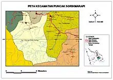
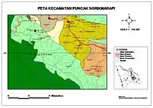
| Puncak Sorik Marapi * | 55.54 | 7,954 | 8,621 | 11 | 22995 |
| Muara Sipongi | 135.70 | 9,670 | 10,486 | 16 | 22998 |
| Pakantan * | 93.60 | 2,146 | 2,322 | 8 | 22997 |
| Panyabungan | 259.77 | 77,449 | 84,153 | 39 | 22915 -22919 |
| Panyabungan Selatan (South Panyabungan) | 87.60 | 9,410 | 10,202 | 11 | 22952 |
| Panyabungan Barat (West Panyabungan) | 87.22 | 8,911 | 9,660 | 10 | 22911 |
| Panyabungan Utara (North Panyabungan) | 63.73 | 19,991 | 21,686 | 14 | 22979 |
| Panyabungan Timur (East Panyabungan) | 397.87 | 12,307 | 13,343 | 15 | 22912 |
| Huta Bargot * | 116.21 | 5,715 | 6,199 | 12 | 22978 |
| Natal | 935.37 | 27,292 | 29,675 | 30 | 22987 |
| Muara Batang Gadis | 1,435.02 | 15,416 | 16,752 | 14 | 22989 |
| Siabu | 345.36 | 47,364 | 51,374 | 28 | 22976 |
| Bukit Malintang | 68.74 | 10,894 | 11,816 | 11 | 22977 |
| Naga Juang * | 58.69 | 3,650 | 3,962 | 7 | 22975 |
| Totals | 6,620.70 | 403,894 | 439,505 | 404 |
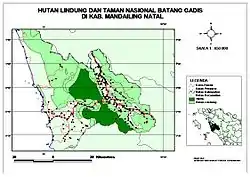
Nationalpark
References
- Badan Pusat Statistik, Jakarta, 2020.
- Seta,William J. Atlas Lengkap Indonesia dan Dunia (untuk SD, SMP, SMU, dan Umum). Pustaka Widyatama. p. 9. ISBN 979-610-232-3.
- Badan Pusat Statistik, Jakarta, 2020.
- Biro Pusat Statistik, Jakarta, 2011.
- Badan Pusat Statistik, Jakarta, 2020.
- Badan Pusat Statistik, Jakarta, 2020.