Tebing Tinggi
Tebing Tinggi Deli or more commonly simply Tebing Tinggi (Jawi: تبيڠ تيڠڬي) is a chartered city (kota) near the eastern coast of North Sumatra, Indonesia. It has an area of 31 km2 and a population at the 2010 National Census of 145,180. Tebing Tinggi is an enclave within Serdang Bedagai Regency, as it is surrounded by Serdang Bedagai Regency, which has a kecamatan (district) bordering the city named Tebingtinggi as well.
Tebing Tinggi
(Kota Tebing Tinggi) | |
|---|---|
| Other transcription(s) | |
| • Jawi | تبيڠ تيڠڬي |
| • Chinese | 直名丁宜 |
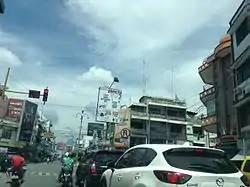 Street view of Tebing Tinggi | |
 Coat of arms | |
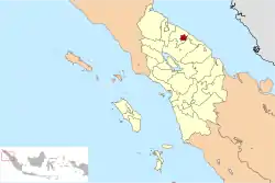 Location within North Sumatra | |
| Coordinates: 3°19′10″N 99°9′8″E | |
| Country | |
| Province | |
| Government | |
| • Mayor | Umar Zunaidi Hasibuan |
| • Vice Mayor | Oki Doni Siregar |
| • Chairman of City's Council of Representatives | Basyaruddin Nasution (Golkar) |
| • Vice Chairmen of City's Council of Representatives | Muhammad Azwar (Nasdem) and Iman Irdian Saragih (PDI-P) |
| Area | |
| • Total | 31 km2 (12 sq mi) |
| Population (2010 Census) | |
| • Total | 145,180 |
| • Density | 4,700/km2 (12,000/sq mi) |
| Time zone | UTC+7 (Indonesia Western Time) |
| Area code | (+62) 621 |
| Website | www |

Geography
According to the Agency for Information and Communication Data North Sumatra, Tebing Tinggi is one of the municipality of 33 districts / municipalities in North Sumatra, located around 80 km from Medan (capital of North Sumatra Province) and it is located at a crossroads of Trans-Sumatran Highway, connecting the East Coast Highway; Tanjungbalai, Rantau Prapat and Central Sumatra Highway; Pematangsiantar, Parapat, and Balige.
Climate
Tebing Tinggi has a tropical rainforest climate (Af) with heavy rainfall year-round.
| Climate data for Tebing Tinggi | |||||||||||||
|---|---|---|---|---|---|---|---|---|---|---|---|---|---|
| Month | Jan | Feb | Mar | Apr | May | Jun | Jul | Aug | Sep | Oct | Nov | Dec | Year |
| Average high °C (°F) | 30.9 (87.6) |
31.5 (88.7) |
31.9 (89.4) |
32.1 (89.8) |
32.3 (90.1) |
32.3 (90.1) |
32.1 (89.8) |
31.8 (89.2) |
31.3 (88.3) |
30.9 (87.6) |
30.6 (87.1) |
30.6 (87.1) |
31.5 (88.7) |
| Daily mean °C (°F) | 26.1 (79.0) |
26.5 (79.7) |
26.8 (80.2) |
27.2 (81.0) |
27.4 (81.3) |
27.2 (81.0) |
27.0 (80.6) |
26.8 (80.2) |
26.7 (80.1) |
26.5 (79.7) |
26.3 (79.3) |
26.2 (79.2) |
26.7 (80.1) |
| Average low °C (°F) | 21.4 (70.5) |
21.5 (70.7) |
21.8 (71.2) |
22.3 (72.1) |
22.6 (72.7) |
22.2 (72.0) |
21.9 (71.4) |
21.9 (71.4) |
22.2 (72.0) |
22.2 (72.0) |
22.0 (71.6) |
21.8 (71.2) |
22.0 (71.6) |
| Average rainfall mm (inches) | 137 (5.4) |
109 (4.3) |
113 (4.4) |
163 (6.4) |
187 (7.4) |
166 (6.5) |
159 (6.3) |
217 (8.5) |
276 (10.9) |
307 (12.1) |
249 (9.8) |
215 (8.5) |
2,298 (90.5) |
| Source: Climate-Data.org[1] | |||||||||||||
Administrative divisions
The city is divided administratively into five districts (kecamatan), tabulated below with their areas and 2010 Census populations:[2]
| Name | Area in km2 | Population Census 2010[2] |
|---|---|---|
| Padang Hulu (Upstream Padang) | 8.74 | 26,714 |
| Tebing Tinggi Kota (Tebing Tinggi Town) | 2.60 | 24,040 |
| Rambutan | 7.77 | 31,371 |
| Bajenis | 9.84 | 33,072 |
| Padang Hilir (Downstream Padang) | 11.00 | 30,051 |
Demographics
The residents of Tebing Tinggi are Malays (70%), Batak (11%) and Chinese (8%). Javanese, Mandailing, Indian and other ethnicities are recognised ethnic minorities. The city's religion is predominantly Islam, followed by Christianity, Buddhism and other religions.
References
- "Climate: Tebing Tinggi". Climate-Data.org. Retrieved 6 November 2020.
- Biro Pusat Statistik, Jakarta, 2011.
External links
| Wikimedia Commons has media related to Tebing Tinggi (North Sumatra). |