Lansingerland
Lansingerland is a municipality in the western Netherlands, in the province of South Holland. It was formed on 1 January 2007, by the merger of the municipalities of Berkel en Rodenrijs, Bleiswijk and Bergschenhoek, collectively known as the "B-Triangle". The former municipality of Tempel, abolished in 1855, is also part of Lansingerland.
Lansingerland | |
|---|---|
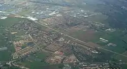 Aerial view of Berkel en Rodenrijs | |
 Flag Coat of arms | |
.svg.png.webp) Location in South Holland | |
| Coordinates: 51°59′N 4°30′E | |
| Country | Netherlands |
| Province | South Holland |
| Established | 1 January 2007[1] |
| Government | |
| • Body | Municipal council |
| • Mayor | Pieter van de Stadt (VVD) |
| Area | |
| • Total | 56.39 km2 (21.77 sq mi) |
| • Land | 53.42 km2 (20.63 sq mi) |
| • Water | 2.97 km2 (1.15 sq mi) |
| Elevation | −5 m (−16 ft) |
| Population (January 2019)[5] | |
| • Total | 61,601 |
| • Density | 1,153/km2 (2,990/sq mi) |
| Time zone | UTC+1 (CET) |
| • Summer (DST) | UTC+2 (CEST) |
| Postcode | 2650–2665 |
| Area code | 010 |
| Website | www |
The name was chosen from a competition and derived from the name Lansingh, the height-of-land between the Delfland and Schieland Water Boards, which runs between the "B-Triangle" villages. The choice of name is symbolic: the name of the border that formerly divided the area, now unites it. The "h" in Lansingh was dropped to ease spelling.
Lansingerland consists of the following communities:
- Bergschenhoek
- Berkel en Rodenrijs
- Bleiswijk
- Tempel (deserted)
- De Rotte
- Kruisweg
Topography
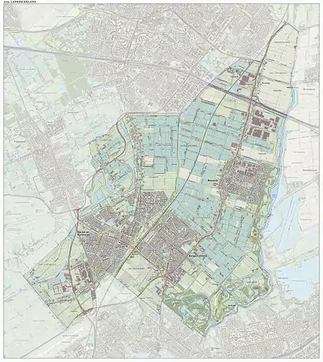
Dutch Topographic map of the municipality of Lansingerland, June 2015
Politics
On 18 September 2007 Ewald van Vliet was installed as the first mayor of Lansingerland.
| Mayors | |||||||||||||||
|---|---|---|---|---|---|---|---|---|---|---|---|---|---|---|---|
| Year | Mayor | ||||||||||||||
| 2015 | Pieter van de Stadt | ||||||||||||||
| 2014 | Coos Rijsdijk | ||||||||||||||
| 2007 | Ewald van Vliet | ||||||||||||||
The municipal council of Lansingerland consists of 31 seats. The council was renewed in 2018 and sits for four-year cycles in accordance with Dutch municipal election laws.
| Council seats | |||||||||||||||
|---|---|---|---|---|---|---|---|---|---|---|---|---|---|---|---|
| Party | 2010 | 2014 | 2018[6] | ||||||||||||
| PvdA | 3 | 2 | 1 | ||||||||||||
| CDA | 6 | 6 | 5 | ||||||||||||
| VVD | 6 | 5 | 7 | ||||||||||||
| GroenLinks | 1 | 1 | 2 | ||||||||||||
| Livable 3B | 9 | 7 | 9 | ||||||||||||
| Party for Protection of Huis der Haas | 1 | - | - | ||||||||||||
| D66 | 2 | 4 | 3 | ||||||||||||
| ChristianUnion | 3 | 3 | 3 | ||||||||||||
| WIJ Lansingerland | - | 2 | 3 | ||||||||||||
| Neeleman Party | - | 1 | 0 | ||||||||||||
| Total | 31 | 31 | 33 | ||||||||||||
Notable people
- Maria van Utrecht (ca.1551 in Rodenrijs - 1629) a notable figure in the Dutch Revolt
- Piet Rietveld (1952 in Berkel en Rodenrijs – 2013) a Dutch economist and Professor in Transport Economics
- Wilco Zeelenberg (born 1966 in Bleiswijk) a Dutch former professional Grand Prix motorcycle road racer
- Joost Luiten (born 1986 in Bleiswijk) a Dutch professional golfer who plays on the European Tour
References
- "Gemeentelijke indeling op 1 januari 2007" [Municipal divisions on 1 January 2007]. cbs.nl (in Dutch). CBS. Retrieved 6 August 2013.
- "Samenstelling B&W" [Mayor and aldermen] (in Dutch). Gemeente Lansingerland. Retrieved 6 August 2014.
- "Kerncijfers wijken en buurten 2020" [Key figures for neighbourhoods 2020]. StatLine (in Dutch). CBS. 24 July 2020. Retrieved 19 September 2020.
- "Postcodetool for 2662SB". Actueel Hoogtebestand Nederland (in Dutch). Het Waterschapshuis. Archived from the original on 21 September 2013. Retrieved 7 August 2013.
- "Bevolkingsontwikkeling; regio per maand" [Population growth; regions per month]. CBS Statline (in Dutch). CBS. 1 January 2019. Retrieved 1 January 2019.
- "Publicised definite results".
External links
Places adjacent to Lansingerland | ||||||||||
|---|---|---|---|---|---|---|---|---|---|---|
| ||||||||||

| Authority control |
|---|