Latouille-Lentillac
Latouille-Lentillac is a commune in the Lot department in south-western France.
Latouille-Lentillac | |
|---|---|
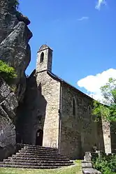 The chapel of Verdale, in Latouille-Lentillac | |
Location of Latouille-Lentillac 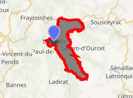
| |
 Latouille-Lentillac  Latouille-Lentillac | |
| Coordinates: 44°51′18″N 1°57′48″E | |
| Country | France |
| Region | Occitanie |
| Department | Lot |
| Arrondissement | Figeac |
| Canton | Saint-Céré |
| Intercommunality | Causses et Vallée de la Dordogne |
| Government | |
| • Mayor (2008–2014) | Jean-Pierre Landes |
| Area 1 | 11.71 km2 (4.52 sq mi) |
| Population (2017-01-01)[1] | 226 |
| • Density | 19/km2 (50/sq mi) |
| Time zone | UTC+01:00 (CET) |
| • Summer (DST) | UTC+02:00 (CEST) |
| INSEE/Postal code | 46159 /46400 |
| Elevation | 184–573 m (604–1,880 ft) (avg. 220 m or 720 ft) |
| 1 French Land Register data, which excludes lakes, ponds, glaciers > 1 km2 (0.386 sq mi or 247 acres) and river estuaries. | |
See also
References
- "Populations légales 2017". INSEE. Retrieved 6 January 2020.
| Wikimedia Commons has media related to Latouille-Lentillac. |
| Authority control |
|---|
This article is issued from Wikipedia. The text is licensed under Creative Commons - Attribution - Sharealike. Additional terms may apply for the media files.
