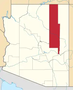
Holbrook, Arizona
Holbrook (Navajo: Tʼiisyaakin) is a town in Navajo County, Arizona, United States. According to the 2010 census, the population of the town was 5,053.[3] The town is the county seat of Navajo County.[5]
Holbrook | |
|---|---|
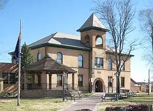 Historic Navajo County Courthouse and Museum | |
| Motto(s): "Gateway to the Petrified Forest" | |
 Location of Holbrook in Navajo County, Arizona | |
| Coordinates: 34°54′26″N 110°9′46″W | |
| Country | United States |
| State | Arizona |
| County | Navajo |
| Incorporated | 1917 |
| Government | |
| • Type | Council-Manager |
| • Body | Holbrook City Council |
| • Mayor | Merrill Young |
| Area | |
| • Total | 17.37 sq mi (44.99 km2) |
| • Land | 17.34 sq mi (44.92 km2) |
| • Water | 0.03 sq mi (0.07 km2) |
| Elevation | 5,082 ft (1,548 m) |
| Population | |
| • Total | 5,053 |
| • Estimate (2019)[4] | 5,084 |
| • Density | 293.13/sq mi (113.18/km2) |
| Time zone | UTC-7 (MST (no DST)) |
| ZIP code | 86025 |
| Area code(s) | 928 |
| FIPS code | 04-33280 |
| GNIS ID(s) | 5871, 2410773 |
| Airport | Holbrook Municipal Airport |
| Website | City of Holbrook |

Holbrook was founded in 1881 or 1882, when the railroad was built, and named to honor the first chief engineer of the Atlantic and Pacific Railroad, Henry Randolph Holbrook.[6]
History
The Holbrook area was inhabited first by the Anasazi, then Puebloans, then the Navajo and Apache. In 1540 (some seventy years before Jamestown or the Pilgrims) Coronado searched for the Seven Cities of Cibola and camped some 60 miles east of Holbrook. Coronado sent an expedition west to find the Colorado River, and they crossed the Little Colorado some twenty-five miles east of Holbrook and found a wonderland of colors they named "El Desierto Pintada" - The Painted Desert. The expedition was then led by the Hopis to the Grand Canyon.
U.S. settlements
After the Mexican–American War ended in 1848 the area was ceded to the United States. From 1851-57 the U.S. Army sent three expeditions along the 35th parallel, the third led by Lt. Beale who created a ten foot wide wagon road. The area was known as Navajo Springs, after a spring a dozen miles northeast of Holbrook. Soon afterwards a store and saloon were established at the confluence of the Rio Puerco and Little Colorado Rivers two miles east of Holbrook, and the area became known as Horsehead Crossing.
In 1876, Mormons emigrated from Utah and began settlements near Horsehead Crossing on both the Little Colorado and Rio Puerco rivers. During 1881 and 1882, railroad tracks were laid down and a railroad station was built to supply wood and water and to freight supplies south to Fort Apache. The community was then named Holbrook after the first engineer of the Atlantic and Pacific Railroad. The railroad sold a million acres to a Boston investment group which established the Aztec Land and Cattle Company, better known as the Hashknife Outfit. It leased another million acres of government land and became one of the largest cattle ranches to ever exist. Holbrook became its headquarters and quickly grew into a cow-town.
Wild west cow-town
The Hashknife Outfit hired cowboys, many of whom were wanted men hiding from arrest. Rustling of cattle and horses over two million acres plagued the Hashknife Outfit. With cowmen, sheepmen, farmers, rustlers and outlaws competing for the same land, a range war ensued, called both the Pleasant Valley War and the Tonto Basin War. It likely killed as many men as any of the western range wars. Many of the events that played out during the Pleasant Valley War up to 1887 occurred in and around Holbrook, including the famous Holbrook Shootout.
Holbrook shootout
On September 4, 1887, Commodore Perry Owens, the Apache County Sheriff, came to Holbrook to arrest Andy Blevins, a.k.a. Andy Cooper, for horse theft. Blevins had also recently bragged about killing two men and had killed many more, including two lawmen.
Sheriff Owens insisted on confronting the Blevins brothers alone, knowing there would likely be a shootout. He went to the Blevins house, which still stands, knocked on the door, and when Blevins asked what he wanted, announced he'd come to arrest him. Blevins resisted arrest and a shootout occurred. Blevins, two brothers, a friend, and Blevins horse were shot; all died, except one brother.
Owens emerged unscathed, despite being shot at from a half-dozen feet away. Owens single-handedly taking on four men made him a western legend rivaling the Earp Brothers and Texas John Slaughter as lawmen of the Old West.
Later development
Holbrook was known as "the town too tough for women and churches" and in 1914 was said to be the only county seat in the U.S. that didn't have a church (the Mormons had moved 25 miles south to Snowflake and Taylor). The original railroad station was replaced by the Santa Fe Depot in 1892.
Navajo County was divided off of Apache County in 1895 and Holbrook became the county seat. Many lawmen and cowboys from the area became Rough Riders with Theodore Roosevelt in the late 1800s. But by 1902, The Hashknife Outfit was bankrupt and the land was sold to the Babbitt brothers.
President Roosevelt named the Petrified Forest (including part of the Painted Desert) a National Monument in 1906. Holbrook was incorporated in 1917. Most of the Beale Wagon Road became Route 66 in 1926 and passed through both the Petrified Forest and Holbrook. Tourism started taking over the economy.
Holbrook meteorite

Arizona is famous for its huge Meteor Crater, but Holbrook also witnessed its own small meteor event. In the evening of July 19, 1912, a smoke trail appeared in the sky and soon after, at 7:15 p.m., a meteorite with an estimated mass of 190 kilograms (419 pounds) exploded high in the atmosphere.
An estimated 16,000 or more minor fragments rained down over Navajo County in an area about 6 miles east of Holbrook. The primary explosion was heard at least 40 miles away and one of the witnesses in Holbrook, then 17-year-old Pauline McCleve, described the event as the loudest sound she ever heard. The largest piece of the Holbrook Meteorite that has been recovered was found shortly after. It weighs 14.5 pounds and resides at Arizona State University in Tempe.
The Holbrook meteorite was found to be of the chondrite (stony) type.[7]
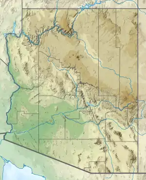
Geography
Holbrook is located at 34°54′26″N 110°9′46″W (34.907203, -110.162882).[8]
According to the United States Census Bureau, the town has a total area of 15.4 square miles (40 km2), all of it land.
Climate
Holbrook has a semi-arid climate (BSk) with cold to cool winters and hot summers. Although the mean snowfall is 0.16 metres (6.30 in), the median is zero, so the majority of winters do not have measurable snow. There are high diurnal temperature variations year-round.
| Climate data for Holbrook, Arizona | |||||||||||||
|---|---|---|---|---|---|---|---|---|---|---|---|---|---|
| Month | Jan | Feb | Mar | Apr | May | Jun | Jul | Aug | Sep | Oct | Nov | Dec | Year |
| Record high °F (°C) | 74 (23) |
99 (37) |
89 (32) |
93 (34) |
101 (38) |
108 (42) |
106 (41) |
109 (43) |
106 (41) |
96 (36) |
89 (32) |
78 (26) |
109 (43) |
| Average high °F (°C) | 50.6 (10.3) |
57.9 (14.4) |
65.1 (18.4) |
73.3 (22.9) |
81.9 (27.7) |
92.2 (33.4) |
95.4 (35.2) |
92.2 (33.4) |
86.3 (30.2) |
74.7 (23.7) |
61.6 (16.4) |
51.5 (10.8) |
73.6 (23.1) |
| Average low °F (°C) | 20.9 (−6.2) |
25.2 (−3.8) |
30.3 (−0.9) |
35.9 (2.2) |
43.3 (6.3) |
51.4 (10.8) |
59.8 (15.4) |
59.0 (15.0) |
50.9 (10.5) |
38.2 (3.4) |
27.6 (−2.4) |
20.9 (−6.2) |
38.6 (3.7) |
| Record low °F (°C) | −20 (−29) |
−19 (−28) |
2 (−17) |
10 (−12) |
13 (−11) |
30 (−1) |
41 (5) |
36 (2) |
18 (−8) |
15 (−9) |
−10 (−23) |
−21 (−29) |
−21 (−29) |
| Average precipitation inches (mm) | 0.71 (18) |
0.66 (17) |
0.72 (18) |
0.37 (9.4) |
0.38 (9.7) |
0.20 (5.1) |
1.17 (30) |
1.51 (38) |
1.18 (30) |
1.07 (27) |
0.66 (17) |
0.57 (14) |
9.2 (233.2) |
| Average snowfall inches (cm) | 1.5 (3.8) |
1.3 (3.3) |
0.7 (1.8) |
0.8 (2.0) |
0 (0) |
0 (0) |
0 (0) |
0 (0) |
0 (0) |
0 (0) |
1.1 (2.8) |
0.9 (2.3) |
6.3 (16) |
| Average precipitation days (≥ 0.01 inch) | 4.0 | 3.5 | 4.6 | 2.7 | 3.3 | 1.6 | 6.0 | 8.0 | 5.4 | 4.1 | 3.0 | 3.6 | 49.8 |
| Average snowy days (≥ 0.1 inch) | 0.8 | 0.7 | 0.6 | 0.1 | 0 | 0 | 0 | 0 | 0 | 0 | 0.6 | 0.6 | 3.4 |
| Source: [9] | |||||||||||||
Demographics
| Historical population | |||
|---|---|---|---|
| Census | Pop. | %± | |
| 1890 | 206 | — | |
| 1910 | 609 | — | |
| 1920 | 1,206 | 98.0% | |
| 1930 | 1,115 | −7.5% | |
| 1940 | 1,184 | 6.2% | |
| 1950 | 2,336 | 97.3% | |
| 1960 | 3,438 | 47.2% | |
| 1970 | 4,759 | 38.4% | |
| 1980 | 5,785 | 21.6% | |
| 1990 | 4,686 | −19.0% | |
| 2000 | 4,917 | 4.9% | |
| 2010 | 5,053 | 2.8% | |
| 2019 (est.) | 5,084 | [4] | 0.6% |
| U.S. Decennial Census[10] | |||
As of the census[11] of 2000, there were 4,917 people, 1,626 households, and 1,195 families residing in the town. The population density was 318.4 people per square mile (122.9/km2). There were 1,906 housing units at an average density of 123.4 per square mile (47.6/km2). The racial makeup of the town was 59.28% White, 24.00% Native American, 2.36% Black or African American, 1.04% Asian, 8.38% from other races, and 4.94% from two or more races. 23.35% of the population were Hispanic or Latino of any race.
There were 1,626 households, out of which 40.7% had children under the age of 18 living with them, 52.3% were married couples living together, 16.4% had a female householder with no husband present, and 26.5% were non-families. Of all households 22.6% were made up of individuals, and 6.8% had someone living alone who was 65 years of age or older. The average household size was 2.93 and the average family size was 3.47.
In the town, the population was spread out, with 35.7% under the age of 18, 9.3% from 18 to 24, 26.5% from 25 to 44, 19.8% from 45 to 64, and 8.7% who were 65 years of age or older. The median age was 30 years. For every 100 females, there were 90.2 males. For every 100 females age 18 and over, there were 87.7 males.
The median income for a household in the town was $31,746, and the median income for a family was $36,349. Males had a median income of $30,797 versus $24,088 for females. The per capita income for the town was $13,912. About 16.6% of families and 20.1% of the population were below the poverty line, including 25.7% of those under age 18 and 3.2% of those age 65 or over.
Points of interest

- Petrified Forest National Park is located 28 miles (45 km) east of Holbrook, the nearest city to the park.
- The Navajo County Courthouse in downtown Holbrook was built in 1898. It is now used by the Navajo County Historical Society and is listed on the National Register of Historic Places.
- Wigwam Motel on Hopi Drive. Built in 1950, it is listed in the National Register of Historic Places as Wigwam Village #6.
- Historic U.S. Route 66 runs through Holbrook.
- Bucket of Blood Street was ranked 6th in "wackiest street names", according to a 2006 poll by Car Connection website.[12]
- Arizona Rancho, in or near Holbrook, is NRHP-listed
- Sidney Sapp House, 215 W. Hopi in Holbrook is NRHP-listed
- South Central Avenue Commercial Historic District in Holbrook is NRHP-listed
- Several historic bridges near Holbrook are also NRHP-listed
Education
- Primary and secondary schools
The city is served by the Holbrook Unified School District and serves 2324 students.
Three elementary schools: Park Elementary School (K–2) and Hulet Elementary School (3–5) serve the city and Indian Wells Elementary (K–6) serves the northern parts of the school district.
Holbrook Junior High School (6–8) and Holbrook High School (9–12) serve the city.
- Colleges and universities
One of the four main campuses of Northland Pioneer College community college is located in Holbrook. The other three main campuses are in Show Low, Snowflake, and Winslow, all in Navajo County, Arizona.
- Public libraries
The Holbrook Public Library is located in Holbrook.[13]
Notable people
- Mike Budenholzer, head coach for the Milwaukee Bucks
- Chester Crandell, politician
- Gene Evans, actor
- Eric B. Shumway, president of Brigham Young University–Hawaii
- Aaron Yazzie, mechanical engineer at NASA's Jet Propulsion Laboratory
Nearest cities and towns
See also
Further reading
- Ellis, Catherine H. (2007). Holbrook and The Petrified Forest. Arcadia Publishing, Charleston, SC. ISBN 978-0-7385-4885-2.
References
- Lyle Johnston, editor, Centennial Memories: A history of Holbrook, Az. 1881–1981, privately printed, 1992.
- "2019 U.S. Gazetteer Files". United States Census Bureau. Retrieved June 30, 2020.
- "Feature Detail Report for: Holbrook". Geographic Names Information System. United States Geological Survey.
- "U.S. Census website". United States Census Bureau. Retrieved 2014-08-23.
- "Population and Housing Unit Estimates". United States Census Bureau. May 24, 2020. Retrieved May 27, 2020.
- "Find a County". National Association of Counties. Archived from the original on 2011-05-31. Retrieved 2011-06-07.
- http://www.azcommerce.com/doclib/commune/holbrook.pdf
- Weir, David. "Holbrook". Meteorite Studies.
- "US Gazetteer files: 2010, 2000, and 1990". United States Census Bureau. 2011-02-12. Retrieved 2011-04-23.
- "HOLBROOK, AZ" (PDF). National Oceanic and Atmospheric Administration. Archived from the original (PDF) on September 10, 2014. Retrieved December 5, 2011.
- "Census of Population and Housing". Census.gov. Retrieved June 4, 2016.
- "U.S. Census website". United States Census Bureau. Retrieved 2008-01-31.
- See the entry for September 19 on Ben Scott, Schott's Miscellany Calendar 2009 (New York: Workman Publishing Company, 2008).
- "Member Libraries." Navajo County Public Library District. Retrieved on January 21, 2011.
External links
| Wikimedia Commons has media related to Holbrook, Arizona. |
| Wikivoyage has a travel guide for Holbrook (Arizona). |
| Authority control |
|---|