List of Texas Capitol View Corridors
Thirty Capitol View Corridors place legal restrictions on construction in Austin, Texas, and five additional corridors have been proposed but not yet implemented. First established by the Texas Legislature in 1983, the corridors aim to preserve the visibility of the Texas State Capitol from various points around the city. The Capitol View Corridors significantly limit the potential for the development of new tall structures in downtown Austin.
List of corridors
A Capitol View Corridor is a quadrilateral that links a line segment somewhere in Greater Austin to the base of the capitol dome. No structure is permitted to be built that would intersect the viewing corridor and thus obstruct the protected view of the capitol.[1] Twenty-one of the corridors protect pedestrian views, and eighteen protect vehicular views from roadways (some corridors protect both). The corridors have an average length of around 1.5 miles (2.4 km); the shortest runs for 1,700 feet (520 m) to Waterloo Park, and the longest runs 5.7 miles (9.2 km) to a scenic overlook in West Lake Hills.[1]
Existing corridors
As of 2020, state law defines thirty Capitol View Corridors in Austin, while municipal code defines twenty-six protected corridors, twenty-one of which are identical to state-defined corridors and five of which differ slightly from five of the state corridors.[1]
| Number | Name | Viewpoint | Pedestrian/Vehicular | Length | Image |
|---|---|---|---|---|---|
| 1 | South Mall of The University of Texas | South Mall of the University of Texas campus | Pedestrian | 3,800 feet (1,200 m) |  |
| 2 | Waterloo Park | Sidewalk along the east edge of Waterloo Park | Pedestrian | 1,700 feet (520 m) |  |
| 3 | Wooldridge Park | South edge of Wooldridge Park | Pedestrian | 1,900 feet (580 m) |  |
| 4 | French Legation | Front porch of the French Legation | Pedestrian | 3,800 feet (1,200 m) |  |
| 5 | Lamar Bridge | Lamar Boulevard Bridge over Lady Bird Lake | Vehicular | 1.2 miles (1.9 km) |  |
| 6 | South Congress at East Live Oak | Along Congress Avenue to the capitol terminating vista | Both | 2.4 miles (3.9 km) | 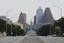 |
| 7 | MoPac Bridge | MoPac Expressway bridge over Lady Bird Lake[a] | Vehicular | 1.9 miles (3.1 km) | |
| 8 | South Lamar at La Casa Drive | Northbound lanes of south Lamar Boulevard | Vehicular | 3.0 miles (4.8 km) |  |
| 9 | Barton Creek Pedestrian Bridge | Barton Creek Bridge on the Ann and Roy Butler Hike-and-Bike Trail in Zilker Park[b] | Pedestrian | 1.6 miles (2.6 km) | |
| 10 | Pleasant Valley Road at Lakeshore Drive | East end of Longhorn Shores park on the south shore of Lady Bird Lake | Pedestrian | 2.6 miles (4.2 km) | |
| 11 | East 11th Street Threshold | East 11th Street's elevated crossing over Interstate 35 | Both | 3,300 feet (1,000 m) |  |
| 12 | Northbound Lanes of Interstate Highway 35 Between the Municipal Police and Courts Building and West 10th Street | A segment of the northbound lanes of I-35 southeast of the capitol[c] | Vehicular | 3,100 feet (940 m) | |
| 13 | Southbound Lanes of the Upper Deck of Interstate Highway 35 Between Concordia College and the Martin Luther King, Jr. Boulevard Overpass | A segment of the elevated southbound lanes of I-35 northeast of the capitol | Vehicular | 1.0 mile (1.6 km) | |
| 14 | Northbound Lanes of Interstate Highway 35 Between Waller Creek Plaza and the Municipal Police and Courts Building | A segment of the northbound lanes of Interstate 35 southeast of the capitol | Vehicular | 3,900 feet (1,200 m) | |
| 15 | Northbound Lanes of Interstate Highway 35 Between 3rd Street and Waller Creek Plaza | A segment of the northbound lanes of Interstate 35 southeast of the capitol | Vehicular | 4,800 feet (1,500 m) | |
| 16 | East 7th Street Bridge over the Texas and New Orleans Railroad | East 7th Street's elevated bridge over the Texas and New Orleans Railroad tracks | Both | 2.4 miles (3.9 km) | |
| 17 | Longhorn Shores | South edge of Longhorn Shores park on the south shore of Lady Bird Lake[d] | Pedestrian | 2.2 miles (3.5 km) | |
| 18 | Zilker Clubhouse | Plaza in front of the Zilker Clubhouse in Zilker Park | Pedestrian | 2.1 miles (3.4 km) | |
| 19 | Redbud Trail | A hill crest along Redbud Trail in West Lake Hills, Texas[e] | Vehicular | 3.4 miles (5.5 km) | |
| 20 | Enfield Road | Eastbound lanes of Enfield Road | Both | 4,800 feet (1,500 m) |  |
| 21 | Capital of Texas Highway | A scenic overlook on the east side of Capital of Texas Highway in West Lake Hills, Texas | Both | 5.7 miles (9.2 km) |  |
| 22 | 38th Street at Red River | Southbound lanes of Red River Street around its intersection with 38th Street[f] | Vehicular | 1.8 miles (2.9 km) | |
| 23 | Robert Mueller Airport | Base of the old air traffic control tower at the former Mueller Airport[g] | Pedestrian | 2.7 miles (4.3 km) | |
| 24 | Martin Luther King, Jr. Boulevard at Interstate Highway 35 | Westbound lanes of Martin Luther King, Jr. Boulevard at its intersection with I-35 | Both | 3,500 feet (1,100 m) |  |
| 25 | Oakwood Cemetery | Comal Street as it runs through Oakwood Cemetery | Both | 5,000 feet (1,500 m) |  |
| 26 | East 12th Street at Interstate Highway 35 | East 12th Street's elevated crossing over I-35 | Both | 3,100 feet (940 m) |  |
| 27 | Lyndon Baines Johnson Library | Terrace of the Lyndon Baines Johnson Library and Museum on the University of Texas campus[f][h] | Pedestrian | 1.0 mile (1.6 km) | |
| 28 | North Congress Avenue at Martin Luther King, Jr. Boulevard | North Congress Avenue from its intersection with Martin Luther King, Jr. Boulevard at the southern edge of the University of Texas campus[h] | Both | 2,300 feet (700 m) |  |
| 29 | Field Level of the Memorial Stadium Practice Center | Practice field to the south of Darrell K Royal–Texas Memorial Stadium on the University of Texas campus[h] | Pedestrian | 3,600 feet (1,100 m) | |
| 30 | Entrance Terrace to the University of Texas Swim Center | Terrace of the Lee and Joe Jamail Texas Swimming Center on the University of Texas campus[h] | Pedestrian | 2,900 feet (880 m) |  |
[a]^ The state and city definitions of this corridor disagree, with the state defining a longer section of the bridge as the protected viewpoint.
[b]^ The state and city definitions of this corridor disagree, with the state defining a point just downstream from the bridge as the protected viewpoint.
[c]^ The state and city definitions of this corridor disagree, with the city defining a longer section of the highway as the protected viewpoint.
[d]^ The state and city definitions of this corridor disagree, with the state defining a wider protected viewpoint, slightly farther north (closer to the lake).
[e]^ The state and city definitions of this corridor disagree, with the city defining a wider protected viewpoint.
[f]^ This corridor was partially obstructed by the addition of an upper seating deck to the east side of Darrell K Royal–Texas Memorial Stadium.
[g]^ Redevelopment of the airport has been exempted from compliance with this viewing corridor.
[h]^ This corridor is defined only under state law (not under city ordinance).
Additional proposed corridors
In February 2017, the Austin City Council considered a proposal to designate additional protected viewing corridors in east Austin.[2] The proposal was provisionally approved by council on February 16, after an amendment removed one of the five proposed new corridors;[3] that corridor was later restored to the proposal on March 2.[4] As of 2020, city staff are reviewing the proposed additional corridors for feasibility.[5]
| Number | Name | Viewpoint | Pedestrian/Vehicular | Length | Image |
|---|---|---|---|---|---|
| 1 | Rosewood Park and Thompson Street | Thompson Street across Rosewood Park | Both | 1.9 miles (3.1 km) | |
| 2 | Lott Park | Lott Park | Pedestrian | 3,500 feet (1,100 m) | |
| 3 | Texas State Cemetery | A hillside within the Texas State Cemetery | Pedestrian | 1.1 miles (1.8 km) | |
| 4 | Juniper and Navasota | Intersection of Juniper Street and Navasota Street | Both | 4,600 feet (1,400 m) |  |
| 5 | Huston–Tillotson University | Jackson Moody Building on the Huston–Tillotson University campus | Pedestrian | 1.3 miles (2.1 km) |
References
- "Downtown Development and Capitol View Corridors" (PDF). Downtown Austin Commission. June 27, 2007. Retrieved November 10, 2017.
- Hicks, Nolan; Novak, Shonda (February 15, 2017). "City Council considers expanding Capitol view corridors in East Austin". Austin American-Statesman. Retrieved November 10, 2017.
- Craver, Jack (February 17, 2017). "Council approves resolution aimed at creating more Capitol View Corridors". Austin Monitor. Retrieved November 10, 2017.
- Neely, Christopher (March 2, 2017). "Approved Capitol View Corridor study could impact development of Central Health's Brackenridge Campus". Community Impact Newspaper. Retrieved November 10, 2017.
- Hasan, Syeda (February 1, 2018). "How Do Capitol View Corridors Preserve Sights Of Austin's Most Famous Building?". KUT. Retrieved 1 February 2018.
External links
| Wikimedia Commons has media related to Texas Capitol View Corridors. |