List of airports in the Bahamas
This is a list of airports in the Bahamas, grouped by island and sorted by location.

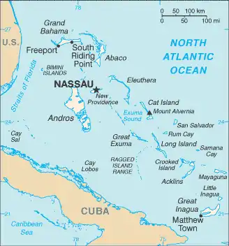
Map of the Bahamas
The Bahamas, officially the Commonwealth of The Bahamas, is an English-speaking country consisting of 29 islands, 661 cays, and 2,387 islets. It is located at the north-east of the Caribbean Sea in the Atlantic Ocean north of Cuba, Hispaniola (Dominican Republic and Haiti) and the Caribbean Sea, northwest of the Turks and Caicos Islands, and southeast of the United States of America (nearest to the state of Florida). Its total land area is almost 14,000 square kilometres (5,400 sq mi), with an estimated population of 330,000. Its capital is Nassau.
Airports
Airport names shown in bold indicate the airport has scheduled service on commercial airlines.
See also
- List of airports by ICAO code: M#MY - Bahamas
- List of islands of the Bahamas
- List of islands of the Bahamas by total area
- Districts of the Bahamas
- Transport in the Bahamas
- Wikipedia: WikiProject Aviation/Airline destination lists: North America#Bahamas
References
- "AirNav: MYAM - Leonard M Thompson International Airport". www.airnav.com.
- "IATA Airport Code Search". International Air Transport Association. Retrieved May 18, 2016.
- Sun-Sentinel, ANN and VINCE MAGNOTTA, Special to the. "NEW PLANES HELP DELIVER VISITORS TO PARADISE ISLAND". Sun-Sentinel.com.
- "Airport Information: The Islands of the Bahamas" (PDF). Archived from the original (PDF) on March 12, 2006. Retrieved April 23, 2006.
- "ICAO Location Indicators by State" (PDF). International Civil Aviation Organization. 2006-01-12.
- "UN Location Codes: Bahamas". UN/LOCODE 2009-2. UNECE. 2010-02-08. - includes IATA codes
- Great Circle Mapper: Airports in the Bahamas - IATA and ICAO airport codes
- World Aero Data: Airports in the Bahamas
- Airport records for Bahamas at Landings.com. Retrieved 2013-08-08
This article is issued from Wikipedia. The text is licensed under Creative Commons - Attribution - Sharealike. Additional terms may apply for the media files.