List of highways in Harris County, Texas
The state highways in Harris County, Texas consists of approximately 1,213 miles (1,952 km) of routes in the Texas state highway system that are located within Harris County.[1] These highways are maintained by the Texas Department of Transportation (TxDOT). These highways are made up of Interstate Highways, U.S. Highways, State Highways, State Loop and Spur Highways, Farm to Market Roads, Park Highways, and Alternate and Business Routes. In addition to these highways, three independent Toll Roads and a section of Interstate 10 that is toll managed are also located in Harris County. These roads are maintained by the Harris County Toll Road Authority, and add approximately 120 miles (190 km) of highways to the overall Harris County highway system.[2]
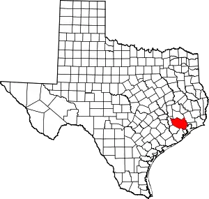 Harris County's location within the state of Texas | |
| System information | |
|---|---|
| Length | 1,212.797 mi (1,951.808 km) |
| Highway names | |
| Interstates | Interstate X (I-X) Interstate Highway X (IH-X) |
| US Highways | U.S. Highway X (US X) |
| State | State Highway X (SH X) |
| Loops: | Loop X |
| Spurs: | Spur X |
| Other roads: | Park Road X (PR X) Farm-to-Market Road X (FM X) Ranch-to-Market Road X (RM X) |
| System links | |
There are four interstates located within Harris County. They consist of three major interstates (Interstate 10 (I-10), known as the Katy Freeway and the East Freeway, Interstate 45 (I-45), known as the Gulf Freeway and the North Freeway, and Interstate 69 (I-69), known as the Southwest Freeway and the Eastex Freeway) and one Auxiliary Interstate (Interstate 610 (I-610), known as "The Loop"). There are also three U.S. Routes located in Harris County. These highways consist of U.S. Route 59 (US 59, known as the Southwest Freeway and the Eastex Freeway), U.S. Route 90 (US 90, known as the Crosby Freeway), and U.S. Route 290 (US 290, known as the Northwest Freeway). There are nine state highways, eight spur and loop highways, one park highway, six toll roads (five independent), twenty-two farm to market roads, four bannered U.S. routes, two bannered state routes, and one bannered farm to market road.
Highways
Interstate Highways and U.S. Highways
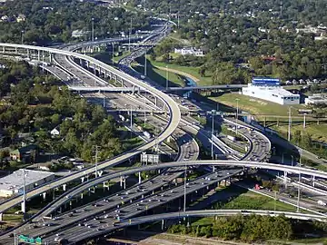
There are four interstate highways located in Harris County. These interstates are I-10, which runs west–east, I-45, which runs south–north, I-69, which also runs south-north, and I-610, which forms a small loop around Downtown Houston.[3][4] I-10 and I-45 run concurrently with each other for a short distance in Downtown Houston. I-10 was created in 1959, with the establishment the Interstate Highway System;[5] I-45 was created in 1971;[6] the first segment of I-69 (concurrent with US 59) was created on July 26, 2012, the second segment (also concurrent with US 59) was created on February 28, 2013, the third and final segment (like the previous two segments is concurrent with US 59 as well) was created on March 25, 2015, when it is fully complete the mainline of I-69 will run from the U.S.–Mexico border in Brownsville to the U.S.–Canada border in Port Huron, MI;[7] I-610 was created in 1959, with the establishment of the Interstate Highway System.[8]
In addition to the four interstate highways, there are also three U.S. Routes. These highways are US 59, which forms the Southwest and Eastex Freeways, and runs southwest-northeast, US 90, which runs concurrently with I-10 from the west county border to I-610, where it becomes the Cosby Freeway, running in a west–east direction, and US 290, which forms the Northwest Freeway, running southeast-northwest.[9][10]
State Highways, Loops, Spurs, and Park Roads
There are currently nine state highways located in Harris County. The longest of these is Texas State Highway 6, which stretches approximately 36.8 miles (59.2 km) from the Fort Bend County line to the Waller County line.[9][10][11] The shortest of these is Texas State Highway 35, which stretches approximately 6 miles (9.7 km) from the Fort Bend County line to Interstate 45 in south Houston.[12] NASA Road 1 is also located in Harris County, and is one of just two state highways in Texas that is not numbered. The other highway is State Highway OSR.[13]
There are currently only one loop highway in Harris County, Texas State Highway Loop 494, which has its south end at I-69 just south of the Harris-Montgomery county line, and Beltway 8, the state's only highway designated as a beltway, forms a large loop around most of Houston.[14] There are six spur routes located in Harris County. The longest is Texas State Highway Spur 261, at 4.6 miles (7.4 km) long.[15] The shortest spur is Texas State Highway Spur 330, at 0.8 miles (1.3 km).[16] There is currently one park road located in Harris County, Texas Park Road 1836.[17] Park Road 1836 serves the San Jacinto Battleground State Historic Site and Battleship Texas. The highway is numbered 1836 to commemorate Texas's year of independence.[18] Park Road 1836 is 7.234 miles (11.642 km) long.[18]
Farm to Market Roads
There are currently twenty-two farm to market roads located in Harris County. Due to the heavy urbanization of Harris County, many of these FM's have been redesignated to Urban Roads under the TxDOT standards, but are still officially signed as Farm to Market Roads.[19] The length of these Farm to Market Roads varies from approximately 37 miles (60 km) long (FM 1960) to just 0.2 miles (0.32 km) (FM 1092).[20]
Toll Roads
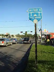
There are seven toll roads located in Harris County. Three of these toll roads are independent toll roads. These consist of the Hardy Toll Road, the Westpark Tollway, and the Fort Bend Toll Parkway. The other four toll roads are state-maintained highways that have been converted to toll highways. These are the Sam Houston Tollway (Beltway 8), the Tomball Tollway (Texas State Highway 249), the Katy Managed Lanes, which is a section of Interstate 10 located between Katy and downtown Houston, and the Grand Parkway (Texas State Highway 99) which is under construction.[2] All toll roads are maintained by the Harris County Toll Road Authority, and are marked with a purple and yellow version of the county highway shield.[2]
Interstate Highways
| Route Name | Direction | Termini | Junctions | Length[3][4] | Remarks | References | |
|---|---|---|---|---|---|---|---|
| mi | km | ||||||
| E–W | Chambers County to Fort Bend County | SH 146 Beltway 8 I-610 I-69/US 59 I-45 SH 6 SH 99 |
56 | 90 | East of I-45 known locally as East Freeway; west of I-45 known locally as Katy Freeway | [5][9][17][21][22] | |
| S–N | Galveston County to Montgomery County | NASA Road 1 Beltway 8 SH 3 I-610 I-69/US 59 I-10/US 90 SH 249 SH 99 Hardy Toll Road |
45 | 72 | South of I-69/US 59 known locally as Gulf Freeway; portion between I-69/US 59 and I-10/US 90 known locally as Pierce Elevated; north of I-10/US 90 known locally as North Freeway | [6][9][10][23] | |
| S–N | Fort Bend County to Montgomery County | Beltway 8 Westpark Tollway I-610 SH 288 I-45 I-10/US 90 |
34 | 55 | Co-signed with US 59; south of SH 288 known locally as Southwest Freeway; north of SH 288 known locally as Eastex Freeway | [7][9][10][21][24] | |
| Orbital | Officially designated from I-10 east of downtown Houston, going counterclockwise | US 90 Hardy Toll Road I-45 US 290 I-10 I-69/US 59 Alternate US 90 SH 288 SH 35 SH 225 |
37.972 | 61.110 | Known locally as "The Loop" | [8][9][25] | |
U.S. Highways
| Route Name | Direction | Termini | Junctions | Length[3][4] | Remarks | References | |
|---|---|---|---|---|---|---|---|
| mi | km | ||||||
| S–N | Fort Bend County to Montgomery County | Beltway 8 Westpark Tollway I-610 SH 288 I-45 I-10/US 90 |
34 | 55 | Co-signed with I-69; south of SH 288 known locally as Southwest Freeway; north of SH 288 known locally as Eastex Freeway | [9][10][21][26][27] | |
| E–W | Liberty County to I-10 | FM 2100 Beltway 8 |
13.5 | 21.7 | Freeway portion from Crosby to I-610 known locally as Crosby Freeway; known locally as Beaumont Highway; officially US 90 follows I-10 after junction, but it is unsigned; US 90 signage restarts in Katy | [9][17][21][28][29][30] | |
| N–S | I-10 to Fort Bend County | I-45 SH 288 I-610 Fort Bend Parkway Toll Road Beltway 8 |
20 | 32 | Known locally as South Wayside Drive north of I-45, Old Spanish Trail between I-45 and Main Street west of SH 288, and South Main Street to Fort Bend County Line; US 90A south of I-610 is a limited-access parkway | [9][28][31] | |
| W–E | I-610 to US 90 /FM 2100 | Beltway 8 | 8.0 | 12.9 | Business route from Houston to Crosby | [9][29][32][33] | |
| E–W | I-610 to Waller County | Beltway 8 SH 6 |
33 | 53 | Known locally as Northwest Freeway | [9][10][34][35][36] | |
| W–E | Waller County to US 290 / SH 6 | FM 2920 | 17 | 27 | Business route through Hempstead, Prairie View, and Waller; former routing of US 290 | [34][37][38] | |
| W–E | US 290 / SH 6 to US 290 / SH 6 | SH 6 | 1.2 | 1.9 | Business route through Cypress | [10][39][40] | |
State Highways
| Route Name | Direction | Termini | Junctions | Length[3][4] | Remarks | References | |
|---|---|---|---|---|---|---|---|
| mi | km | ||||||
| S–N | Galveston County to I-45 | NASA Road 1 Beltway 8 |
8 | 13 | Known locally as Old Galveston Road | ||
| S–N | Fort Bend County to Waller County | Westpark Tollway FM 1093 US 290 FM 1960 |
30 | 48 | Overlaps US 290 after its junction, which it follows out of the county | [9][10][34][42][43] | |
| N–S | I-45 to Brazoria County | Beltway 8 | 6 | 9.7 | Signage begins at I-45/I-610 Junction; known locally as Reveille Street between I-610 and Telephone Road, and known as Telephone Road from just north of Sims Bayou to Brazoria County | ||
| N–S | I-45 to Brazoria County | Beltway 8 | 6 | 9.7 | Future State Highway 35, Spur 5 begins at an onramp located at Jefferson and Dowling streets (where a State Highway 35 sign is visible), and is unsigned on the upper deck of I-45 until it exits at Calhoun; spur ends at US Alternate 90 (Old Spanish Trail). | ||
| S–N | I-69/US 59 (in Fort Bend County) to I-10/US 90 in Katy | Westpark Tollway (in Fort Bend County) FM 1093 (in Fort Bend County) |
17.4 | 28.0 | SH 99 is the toll-free frontage roads of the Grand Parkway. | ||
| S–N | I-10/US 90 in Katy to US-290/SH 6 in Hockley | FM 529 |
15.4 | 24.8 | SH 99 is the toll-free frontage roads of the Grand Parkway. | ||
| S–N & W–E | US-290/SH 6 in Hockley to SH 249 | No major junctions | |||||
| W–E | SH 249 to I-45 | FM 2920 |
|||||
| W–E | I-45 to I-69/US 59 (in Montgomery County) | Hardy Toll Road |
|||||
| S–N | Bus. SH 146-E in Baytown (temporary) to I-10 near Mont Belvieu (in Chambers County) | I-10 (in Chambers County) | 14 | 23 | SH 99 is the toll-free frontage roads of the Grand Parkway. | ||
| S–N | Galveston County to Chambers County | NASA Road 1 SH 225 I-10 |
16 | 26 | Known in Baytown as Bob Lanier Freeway; bridge over the Houston Ship Channel called the Fred Hartman Bridge | ||
| S–N | SH 146 to Broadway Street | Spur 501 | 1.8 | 2.9 | Business route to La Porte | ||
| S–N | SH 146 to SH 146 | SH 99 (temporary) SH 146 |
6.3 | 10.1 | Business route through Baytown | ||
| E–W | SH 146 to just west of I-610 | Beltway 8 I-610 |
15.6 | 25.1 | Known in Houston as La Porte Freeway and in Pasadena as Pasadena Freeway | ||
| S–N | I-45 to Montgomery County | Beltway 8 FM 1960 |
22 | 35 | Portion from Beltway 8 to just south of Tomball is a freeway; highway and freeway may possibly be expanded to SH 6 in Navasota.[51] | ||
| N–S | I-45 to Brazoria County | I-69/US 59 US 90 Alt. I-610 Beltway 8 |
11 | 18 | Known locally as South Freeway | ||
State Highway Loops and Spurs
| Route Name | Direction | Termini | Junctions | Length[3][4] | Remarks | |
|---|---|---|---|---|---|---|
| mi | km | |||||
| W–E | I-45 / FM 528 to SH 146 | SH 3 FM 270 |
7.5 | 12.1 | Main route to NASA's Lyndon B. Johnson Space Center | |
| Orbital | Officially designated from I-45 north of downtown Houston, going clockwise | Hardy Toll Road I-69/US 59 US 90 I-10 SH 225 SH 3 I-45 SH 35 SH 288 US 90 Alt. Westpark Tollway FM 1093 US 290 SH 249 |
83.128 | 133.782 | Secondary loop of metro Houston, with a radius from downtown Houston of about 8 miles (13 km); main lanes are part of the Sam Houston Tollway while Beltway 8 comprises the service lanes; section between I-45 and I-69/US 59 is a freeway | |
| N–S | Dowling Street in downtown Houston to US 90 Alt. | I-45 | 2.929 | 4.714 | Runs concurrent with I-45 from south of downtown to exit 44B; freeway grade from Downling Street to University Drive; proposed future corridor for a new SH 35 freeway | |
| N–S | I-45 to I-610 | No major junctions | 4.611 | 7.421 | Known locally as North Shepherd Drive | |
| S–N | Garth Road in Baytown to I-10 | SH 146 | 0.863 | 1.389 | Short freeway-grade connector serving Baytown; known locally as Decker Drive | |
| S–N | Bayport Ship Channel to Bus. SH 146-D | No major junctions | 1.5 | 2.4 | ||
| S–N | I-69/US 59 to Westheimer Road in Houston | No major junctions | 0.8 | 1.3 | Short freeway-grade connector serving Midtown neighborhood | |
| S–N | I-610 to Hardy Toll Road | Sam Houston Tollway | 1.5 | 2.4 | Unsigned, part of Hardy Toll Road | |
State Park Roads
| Route Name | Direction | Termini | Junctions | Length[3][4] | Remarks | |
|---|---|---|---|---|---|---|
| mi | km | |||||
| S–N | Battleground Rd. to San Jacinto Battleground State Historic Site | San Jacinto Battleground State Historic Site | 7.2 | 11.6 | With state designation canceled over Battleground Rd. (formerly SH 134), PR 1836 no longer connects to rest of state highway system; formally PR 9 | |
Toll Roads
All Harris County toll roads are maintained by the Harris County Toll Road Authority.
| Route Name | Direction | Termini | Junctions | Length[3][4] | Remarks | |
|---|---|---|---|---|---|---|
| mi | km | |||||
| Orbital | Middle Loop around Houston | SH 225 SH 3 I-45 SH 35 SH 288 Fort Bend Parkway Toll Road US 90 Alt. I-69/US 59 Westpark Tollway I-10 US 90 US 290 SH 249 |
83.128 | 133.782 | Main lane portion of Beltway 8 secondary loop; the remaining portion of the loop is free | |
| S–N | I-610 to I-45 | Beltway 8 FM 1960 SH 99 |
21.6 | 34.8 | Runs parallel to I-45; possible future expansion south to I-10 | |
| S–N | Spring-Cypress Road to FM 2920 | SH 99 | 6 | 9.7 | Main lane portion of SH 249; will be extended north into Montgomery County and Grimes County as well as into Bryan-College Station in Brazos County; locally known as Aggie Expressway north of Tomball | |
| E–W | Westpark Drive in Houston to Fort Bend County | I-69/US 59 Beltway 8 SH 6 |
14 | 23 | Runs parallel to Westheimer Road (FM 1093); possible future expansion east to I-610 | |
| E–W | US 90 Alt. to Fort Bend County | Beltway 8 | 6.2 | 10.0 | Runs along Hillcroft Avenue; possible future expansion north to I-610; formerly part of SH 122 project | |
| S–N | I-69/US 59 (in Fort Bend County) to I-10/US 90 in Katy | Westpark Tollway (in Fort Bend County) FM 1093 (in Fort Bend County) |
17.4 | 28.0 | The Grand Parkway is the main lane portion of SH 99 that is currently under construction as the third freeway-grade loop around Greater Houston; opened in 1994. *Mostly free, with only overpasses between FM 1093 and I-69/US 59 tolled. | |
| S–N | I-10/US 90 in Katy to US-290/SH 6 in Hockley | FM 529 | 15.4 | 24.8 | The Grand Parkway is the main lane portion of SH 99 that is currently under construction as the third freeway-grade loop around Greater Houston; opened in 2013, electronic tolling using Tx-Tag, TollTag or EZ-Tag. | |
| S–N & W–E | US-290/SH 6 in Hockley to SH 249 | No major junctions | ||||
| W–E | SH 249 to I-45 | FM 2920 | ||||
| W–E | I-45 to I-69/US 59 (in Montgomery County) | Hardy Toll Road | ||||
| S–N | Bus. SH 146-E in Baytown (temporary) to I-10 near Mont Belvieu (in Chambers County) | I-10 (in Chambers County) | 14 | 23 | The Grand Parkway is the main lane portion of SH 99 that is currently under construction as the third freeway-grade loop around Greater Houston; phase I of this segment opened in 2008, electronic tolling using Tx-Tag, TollTag or EZ-Tag; phase II in planning stages, planned to be tolled. | |
Farm and Ranch to Market Roads
| Route Name | Direction | Termini | Junctions | Length[3][4] | Remarks | |
|---|---|---|---|---|---|---|
| mi | km | |||||
| N–S | NASA Road 1 to Galveston County | No major junctions | 0.3 | 0.48 | Known locally as Egret Bay Boulevard | |
| W–E | Waller County back to Waller County | No major junctions | 0.6 | 0.97 | Concurrent with FM 1488 in very northwest corner of county | |
| S–N | US 90 Alt. to Brazoria County | Beltway 8 I-610 |
6.3 | 10.1 | Known locally as Almeda Rd. | |
| E–W | I-69/US 59 to I-45 | Hardy Toll Road | 7.054 | 11.352 | Known locally as Aldine-Bender Road | |
| S–N | I-10 to Bus. US 90-U | US 90 | 4.625 | 7.443 | Known locally as Maxie Road | |
| E–W | I-45 / NASA Road 1 to Brazoria County | No major junctions | 0.5 | 0.80[note 1] | Known locally as Friendswood Boulevard | |
| E–W | US 290 to Waller County | SH 6 SH 99 |
17 | 27.4[note 1] | Sometimes referred to as Spencer Boulevard | |
| N–S | US 90 Alt. to Brazoria County | I-610 Beltway 8 |
9.5 | 15.3[note 1] | Known locally as Cullen Boulevard | |
| N–S | I-69/US 59 to Fort Bend County | No major junctions | 0.2 | 0.32[note 1] | Known locally as Murphy Road | |
| E–W | I-610 to Fort Bend County | Beltway 8 SH 6 |
13.9 | 22.4[note 1] | A section of FM 1093 is also a section of Westheimer Road | |
| E–W | Montgomery County to Huffman Cleveland Road | No major junctions | 1.1 | 1.8 | ||
| W–E | Waller County back to Waller County | No major junctions | 0.6 | 0.97 | Concurrent with FM 362 in very northwest corner of county | |
| N–S | Waller County back to Waller County | No major junctions | 0.5 | 0.80 | Runs in very northwest corner of county | |
| N–S | Bellaire Boulevard in Alief to Fort Bend County | No major junctions | 2.2 | 3.5 | Known locally as Synott Road | |
| E–W | Chambers County to US 90 | No major junctions | 8.4 | 13.5 | Known locally as Crosby-Cedar Bayou Road | |
| W–E | I-45 to SH 3 | No major junctions | 1.339 | 2.155 | Known locally as Dixie Farm to Market Road | |
| W–E | US 290 to Liberty County | SH 249 I-45 Hardy Toll Road I-69/US 59 |
39 | 62.8[note 1] | Long thoroughfare through northern suburbs of Houston | |
| W–E | FM 1960 to FM 1960 | I-69/US 59 | 4.124 | 6.637 | Business route through Humble | |
| S–N | US 90 to FM 1485 | FM 1960 US 90 (Crosby Freeway) Bus. US 90-U |
14.285 | 22.989 | Known locally as Crosby-Huffman Road | |
| W–E | Galveston County to SH 3 | I-45 | 1 | 1.6[note 1] | Known locally as Edgewood Drive | |
| W–E | I-45 to SH 3 | No major junctions | 1.152 | 1.854 | Known locally as Scarsdale Boulevard | |
| W–E | Bus. US 290 to I-45 | US 290/SH 6 SH 249 FM 2978 |
30.849 | 49.647 | Sometimes referred to as Waller-Tomball Road | |
| S–N | FM 2920 to Montgomery County | No major junctions | 3.5 | 5.6[note 1] | Known locally as Huffsmith-Conroe Road | |
| ||||||
Adjacent counties
- Montgomery County (north)
- Liberty County (northeast)
- Chambers County (east)
- Galveston County (southeast)
- Brazoria County (south)
- Fort Bend County (southwest)
- Waller County (northwest)
See also
 Texas portal
 U.S. Roads portal
References
- Staff. "Houston District Statistics: Centerline Miles (9/1/2010 thru 8/31/2011)". Texas Department of Transportation. Retrieved May 21, 2012.
- Staff. "Toll Road Information - Overview". Harris County Toll Road Authority. Retrieved May 20, 2012.
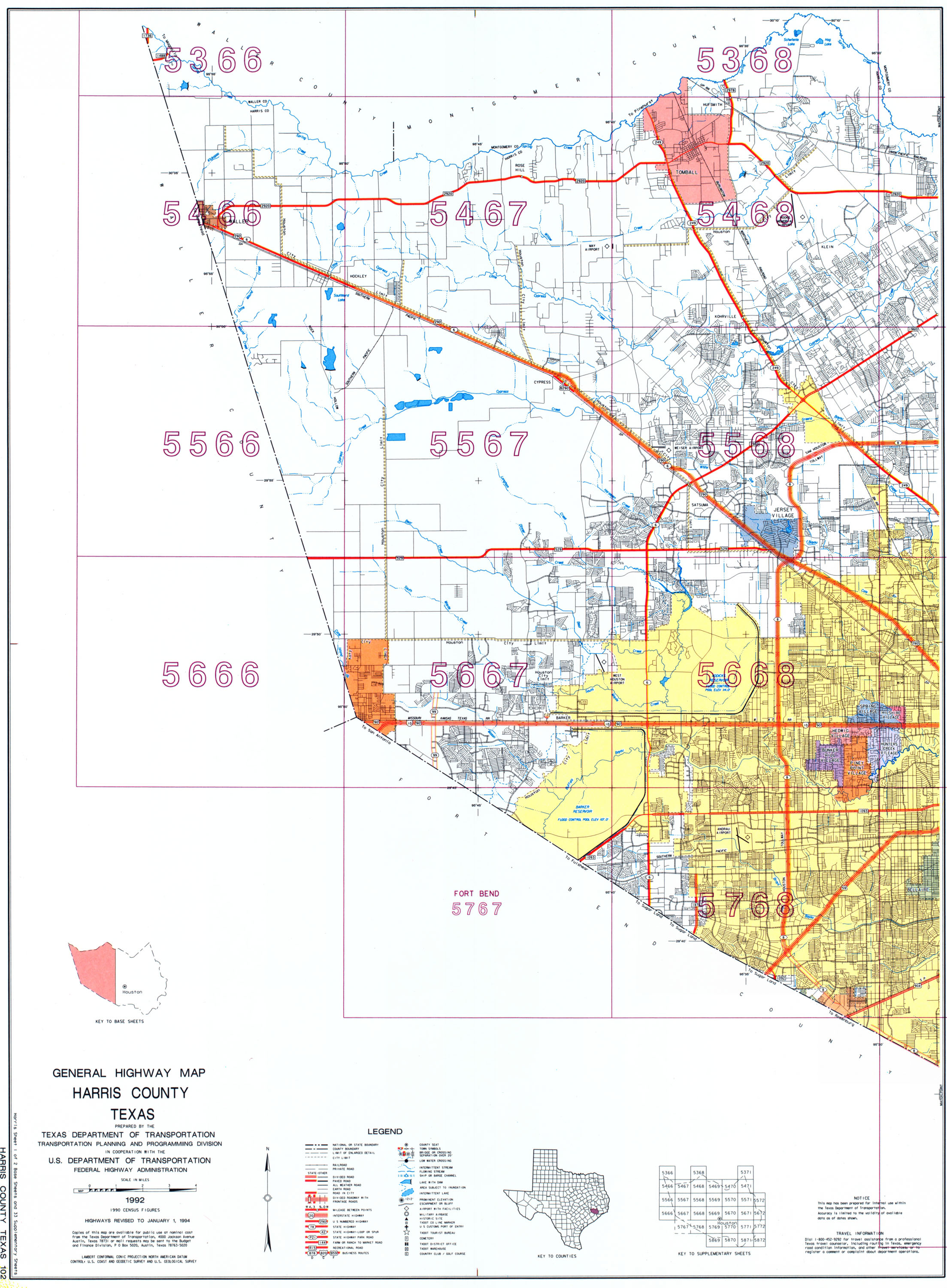
- General Highway Map - Harris County, Texas (Map). Cartography by Transportation Planning and Programming Division. Texas Department of Transportation. 1992. Sheet 1. Retrieved May 21, 2012.
- General Highway Map - Harris County, Texas (Map). Cartography by Transportation Planning and Programming Division. Texas Department of Transportation. 1992. Sheet 2. Retrieved May 21, 2012.
- Transportation Planning and Programming Division (n.d.). "Interstate Highway No. 10". Highway Designation Files. Texas Department of Transportation.
- Transportation Planning and Programming Division (n.d.). "Interstate Highway No. 45". Highway Designation Files. Texas Department of Transportation.
- Transportation Planning and Programming Division (n.d.). "Interstate Highway No. 69". Highway Designation Files. Texas Department of Transportation.
- Transportation Planning and Programming Division (n.d.). "Interstate Highway No. 610". Highway Designation Files. Texas Department of Transportation.
- Transportation Planning and Programming Division (2012). Texas County Mapbook (PDF) (Map) (2012 ed.). 1:120,000. Texas Department of Transportation. p. 562. OCLC 867856197. Retrieved May 20, 2012.
- Transportation Planning and Programming Division (2012). Texas County Mapbook (PDF) (Map) (2012 ed.). 1:120,000. Texas Department of Transportation. p. 561. OCLC 867856197. Retrieved May 20, 2012.
- Transportation Planning and Programming Division (2012). Texas County Mapbook (PDF) (Map) (2012 ed.). 1:120,000. Texas Department of Transportation. p. 563. OCLC 867856197. Retrieved May 20, 2012.
- Transportation Planning and Programming Division (2012). Texas County Mapbook (PDF) (Map) (2012 ed.). 1:120,000. Texas Department of Transportation. p. 583. OCLC 867856197. Retrieved May 20, 2012.
- Texas Department of Transportation. "Highway Designation File - State Highway Old San Antonio Road (OSR)". Retrieved May 20, 2012.
- Transportation Planning and Programming Division (n.d.). "State Highway Loop No. 8". Highway Designation Files. Texas Department of Transportation.
- Transportation Planning and Programming Division (n.d.). "State Highway Spur No. 261". Highway Designation Files. Texas Department of Transportation.
- Transportation Planning and Programming Division (n.d.). "State Highway Spur No. 330". Highway Designation Files. Texas Department of Transportation.
- Transportation Planning and Programming Division (2012). Texas County Mapbook (PDF) (Map) (2012 ed.). 1:120,000. Texas Department of Transportation. p. 582. OCLC 867856197. Retrieved May 20, 2012.
- Transportation Planning and Programming Division (n.d.). "Park Road No. 1836". Highway Designation Files. Texas Department of Transportation.
- Staff. "Section 2: Urban Streets". Texas Department of Transportation. Archived from the original on June 5, 2012. Retrieved May 20, 2012.
- Transportation Planning and Programming Division (n.d.). "Urban Road No. 1092". Highway Designation Files. Texas Department of Transportation.
- Transportation Planning and Programming Division (2012). Texas County Mapbook (PDF) (Map) (2012 ed.). 1:120,000. Texas Department of Transportation. p. 451. OCLC 867856197.
- Google (May 21, 2012). "Overview Map of I-10 in Harris County" (Map). Google Maps. Google. Retrieved May 21, 2012.
- Google (May 21, 2012). "Overview Map of I-45 in Harris County" (Map). Google Maps. Google. Retrieved May 21, 2012.
- Google (June 5, 2015). "Overview Map of I-69 in Harris County" (Map). Google Maps. Google. Retrieved June 5, 2015.
- Google (May 21, 2012). "Overview Map of I-610 in Harris County" (Map). Google Maps. Google. Retrieved May 21, 2012.
- Transportation Planning and Programming Division (n.d.). "U.S. Highway No. 59". Highway Designation Files. Texas Department of Transportation.
- Google (May 21, 2012). "Overview Map of US 59 in Harris County" (Map). Google Maps. Google. Retrieved May 21, 2012.
- Transportation Planning and Programming Division (n.d.). "U.S. Highway No. 90". Highway Designation Files. Texas Department of Transportation.
- Transportation Planning and Programming Division (2012). Texas County Mapbook (PDF) (Map) (2012 ed.). 1:120,000. Texas Department of Transportation. p. 581. OCLC 867856197.
- Google (May 21, 2012). "Overview Map of US 90 in Harris County" (Map). Google Maps. Google. Retrieved May 21, 2012.
- Google (May 23, 2012). "Overview Map of US 90 Alt." (Map). Google Maps. Google. Retrieved May 23, 2012.
- Transportation Planning and Programming Division. "Highway Designation File - Business U.S. Highway 90-U". Texas Department of Transportation.
- Google (May 23, 2012). "Overview Map of US 90 Bus." (Map). Google Maps. Google. Retrieved May 23, 2012.
- Transportation Planning and Programming Division (2012). Texas County Mapbook (PDF) (Map) (2012 ed.). 1:120,000. Texas Department of Transportation. p. 540. OCLC 867856197.
- Transportation Planning and Programming Division (n.d.). "U.S. Highway No. 290". Highway Designation Files. Texas Department of Transportation.
- Google (May 23, 2012). "Overview Map of US 290 in Harris County" (Map). Google Maps. Google. Retrieved May 23, 2012.
- Transportation Planning and Programming Division. "Highway Designation File - Business U.S. Highway 290-H". Texas Department of Transportation. Archived from the original on 2012-10-08.
- Google (May 24, 2012). "Overview Map of BUS US 290-H in Harris County" (Map). Google Maps. Google. Retrieved May 24, 2012.
- Transportation Planning and Programming Division. "Highway Designation File - Business U.S. Highway 290-L". Texas Department of Transportation.
- Google (May 29, 2012). "Overview Map of Bus. US 290-L" (Map). Google Maps. Google. Retrieved May 29, 2012.
- Transportation Planning and Programming Division (n.d.). "State Highway No. 3". Highway Designation Files. Texas Department of Transportation.
- Transportation Planning and Programming Division (n.d.). "State Highway No. 6". Highway Designation Files. Texas Department of Transportation.
- Google (May 23, 2012). "Overview Map of SH 6 in Harris County" (Map). Google Maps. Google. Retrieved May 23, 2012.
- Transportation Planning and Programming Division (n.d.). "State Highway No. 35". Highway Designation Files. Texas Department of Transportation.
- Transportation Planning and Programming Division (n.d.). "State Highway No. 99". Highway Designation Files. Texas Department of Transportation.
- Transportation Planning and Programming Division (n.d.). "State Highway No. 146". Highway Designation Files. Texas Department of Transportation.
- Texas Department of Transportation. "Highway Designation File - Business State Highway 146-D Archived October 10, 2012, at the Wayback Machine"
- Texas Department of Transportation. "Highway Designation File - Business State Highway 146-E Archived October 10, 2012, at the Wayback Machine"
- Transportation Planning and Programming Division (n.d.). "State Highway No. 225". Highway Designation Files. Texas Department of Transportation.
- Transportation Planning and Programming Division (n.d.). "State Highway No. 249". Highway Designation Files. Texas Department of Transportation.
- "Brazos Valley Council considers toll road to fund transportation needs". Bryan-College Station Eagle. Archived from the original on 2007-09-27.
- Transportation Planning and Programming Division (n.d.). "State Highway No. 288". Highway Designation Files. Texas Department of Transportation.
- Texas Department of Transportation. "Highway Designation File - State Highway NASA Road 1"
- Transportation Planning and Programming Division (n.d.). "State Highway Spur No. 5". Highway Designation Files. Texas Department of Transportation.
- Transportation Planning and Programming Division (n.d.). "State Highway Spur No. 501". Highway Designation Files. Texas Department of Transportation.
- Transportation Planning and Programming Division (n.d.). "State Highway Spur No. 527". Highway Designation Files. Texas Department of Transportation.
- Transportation Planning and Programming Division (n.d.). "State Highway Spur No. 548". Highway Designation Files. Texas Department of Transportation.
- Staff. "About the Fort Bend County Toll Road Authority". Fort Bend County Toll Road Authority. Retrieved May 20, 2012.
- Transportation Planning and Programming Division (n.d.). "Farm to Market Road No. 270". Highway Designation Files. Texas Department of Transportation.
- Transportation Planning and Programming Division (n.d.). "Farm to Market Road No. 362". Highway Designation Files. Texas Department of Transportation.
- Transportation Planning and Programming Division (n.d.). "Farm to Market Road No. 521". Highway Designation Files. Texas Department of Transportation.
- Transportation Planning and Programming Division (n.d.). "Farm to Market Road No. 525". Highway Designation Files. Texas Department of Transportation.
- Transportation Planning and Programming Division (n.d.). "Farm to Market Road No. 526". Highway Designation Files. Texas Department of Transportation.
- Transportation Planning and Programming Division (n.d.). "Farm to Market Road No. 528". Highway Designation Files. Texas Department of Transportation.
- Transportation Planning and Programming Division (n.d.). "Farm to Market Road No. 529". Highway Designation Files. Texas Department of Transportation.
- Transportation Planning and Programming Division (n.d.). "Farm to Market Road No. 865". Highway Designation Files. Texas Department of Transportation.
- Transportation Planning and Programming Division (n.d.). "Farm to Market Road No. 1092". Highway Designation Files. Texas Department of Transportation.
- Transportation Planning and Programming Division (n.d.). "Farm to Market Road No. 1093". Highway Designation Files. Texas Department of Transportation.
- Transportation Planning and Programming Division (n.d.). "Farm to Market Road No. 1485". Highway Designation Files. Texas Department of Transportation.
- Transportation Planning and Programming Division (n.d.). "Farm to Market Road No. 1488". Highway Designation Files. Texas Department of Transportation.
- Transportation Planning and Programming Division (n.d.). "Farm to Market Road No. 1736". Highway Designation Files. Texas Department of Transportation.
- Transportation Planning and Programming Division (n.d.). "Farm to Market Road No. 1876". Highway Designation Files. Texas Department of Transportation.
- Transportation Planning and Programming Division (n.d.). "Farm to Market Road No. 1942". Highway Designation Files. Texas Department of Transportation.
- Transportation Planning and Programming Division (n.d.). "Farm to Market Road No. 1959". Highway Designation Files. Texas Department of Transportation.
- Transportation Planning and Programming Division (n.d.). "Farm to Market Road No. 1960". Highway Designation Files. Texas Department of Transportation.
- Texas Department of Transportation. "Highway Designation File - Business Farm to Market Road No. 1960-A. Retrieved 2009-12-27.
- Transportation Planning and Programming Division (n.d.). "Farm to Market Road No. 2100". Highway Designation Files. Texas Department of Transportation.
- Transportation Planning and Programming Division (n.d.). "Farm to Market Road No. 2351". Highway Designation Files. Texas Department of Transportation.
- Transportation Planning and Programming Division (n.d.). "Farm to Market Road No. 2553". Highway Designation Files. Texas Department of Transportation.
- Transportation Planning and Programming Division (n.d.). "Farm to Market Road No. 2920". Highway Designation Files. Texas Department of Transportation.
- Transportation Planning and Programming Division (n.d.). "Farm to Market Road No. 2978". Highway Designation Files. Texas Department of Transportation.