Westheimer Road
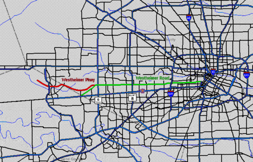
Westheimer Road (/ˈwɛst(h)aɪmər/) is an arterial east-west road in Houston, Texas, United States. It runs from Bagby Street in downtown Houston, and terminates at the Westpark Tollway on the southern edge of George Bush Park, stretching about 19 miles (30.5 km) long. The street was named after Michael Louis Westheimer, a German immigrant and flour salesman.

| Location | Harris and Fort Bend counties |
|---|---|
| From | Bagby Street |
| Major junctions | |
| To |
Route description
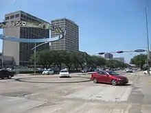
Westheimer Road's eastern terminus is at Bagby Street. At this point, traffic heading east on Westheimer either turns southwest on Bagby Street or jogs right and southeasterly, continuing on Elgin Street into Midtown, and into Third Ward near the University of Houston. From Bagby west, Westheimer jogs mostly westerly, through Neartown, forms the south boundary of the River Oaks community, and then passes under the west 610 Loop.
The portion spanning from Interstate 610 west to the Westpark Tollway is designated as a part of Farm to Market Road 1093.[1][2][3] From the 610 Loop west, Westheimer Road traverses through Uptown and then west-southwest to Chimney Rock. From Chimney Rock west, Westheimer is straight along a cardinal east–west line. Westheimer passes north of Alief and Westchase when passing under Beltway 8. After intersecting Highway 6 and passing west of West Oaks Mall, Westheimer Road and Westheimer Parkway split, with Westheimer Parkway continuing west through George Bush Park and Westheimer Road (a.k.a., "Old Westheimer Road") turning southwest. Westheimer Road terminates when FM 1093 becomes the feeder road of the Westpark Tollway just west of FM 1464 and just inside Fort Bend County.
Character of Various Segments
John Nova Lomax of the Houston Press said in a 2006 article that Westheimer Road, "more than any other thoroughfare, embodies Houston's car-enamored, zoning-free ethos, a damn-near 20-mile phantasmagoria of strip malls, storage facilities, restaurants, big-box retail, office parks, apartment complexes, strip clubs, malls, supermarkets and the occasional church."[4] In another article he referred to Westheimer as "mainly about the fetishes, broken dreams and vanities of Anglo whites."[5]
In a post on the Houston Press website during the same year, he called the stretch of Westheimer west of Chimney Rock Road and east of Fondren Road, which he refers to as "Mid-Westheimer," "The Testosterone Zone." Referring to a photograph of a shopping center on that segment, Lomax added that "This strip center is the essence of that -- Evans Music City, an army surplus store, a titty bar and a liquor store within 100 yards of each other. Now that's one-stop shopping."[6] In Houston Architectural Guide, Stephen Fox said the following about the stretch of Westheimer between Chimney Rock Road and South Gessner Road:
Nowhere is the 'anything goes' image that adheres to Houston more blatantly displayed than along the stretch of Westheimer Road between Chimney Rock and South Gessner Road. Middle-class subdivisions of the 1950s flank this strip, but they are hidden behind broad bands of commercial development that face Westheimer. Most of these date from the 1960s and early '70s, when Houston's suburbanizing ethos was at its least constrained. Not only do shopping centers, gas stations and fast-food restaurants line up along Westheimer -- each flashing signs or theme-style inducements to passersby -- but mega-garden apartment complexes compete for attention in a mixture of dimly recognizable 'traditional' styles. The order of the strip is economic, rather than visual or experiential. The biggest-grossing land gets the prime footage."[7]
Lomax said that the segment of Westheimer in Westchase is "virtually all chains -- a Geography of Nowhere wasteland of Boston Market, Borders, Kroger, Randalls, Taco Bell, Citgo and Sonic. Several of the six CVS outlets we passed are there, as are a few of the uncountable Starbucks." He added that the segment of Westheimer Road in Westchase does not have "the sleaze of the Highway 6 area and the tacky exuberance of mid-Westheimer, the area between Chimney Rock and Fondren."[8]
In 2007 Colliers International ranked Westheimer Road as the seventh most expensive retail streets in the United States by rent per square foot; the group calculated the rent per square foot as $120 United States dollars.[9]
In 2007 Mimi Swartz of Texas Monthly referred to a stretch of Westheimer between Claremont Lane and Kirby Drive as "the socialite’s sector" due to the stores catering to residents of River Oaks and other nearby wealthy communities; in the article she describes several places along the stretch of Westheimer.[10]
Between Willowick Road and Sage Rd, Westheimer is lined with prestigious boutiques and high-end stores that feature luxury goods. Among shopping centers in this section include The Galleria and River Oaks District and many others. Brands that feature boutiques include Apple, Tom Ford, Gucci, Fendi, Christian Dior SE, Dolce & Gabbana, John Hardy, Cartier, Carolina Herrera, Prada, Rolex, Versace, etc.
Lower Westheimer
Between Shepherd Dr and Bagby St, the street is known as Lower Westheimer. The area is famous for its hipster culture, food scene and nightlife. Thrift stores, tattoo shops and bars dominate the area. Westheimer is the Main Street of the Montrose neighborhood which was dubbed as one of the greatest neighborhoods of the United States.[11] The arts culture is widespread, with graffiti being places in buildings throughout. [12]
Westheimer Parkway
From its eastern terminus at Westheimer Road / FM 1093, Westheimer Parkway winds through George Bush Park and the Cinco Ranch neighborhood in Harris County and Fort Bend County. The Parkway then runs under Grand Parkway near Cinco Ranch High School. Westheimer Parkway's western terminus is in Fort Bend County, Texas approximately 3.5 miles (5.6 km) northwest of Grand Parkway. At this point, traffic heading northwest on Westheimer Parkway continues on Pin Oak Road near Katy Mills Mall, located in Katy.

History
Westheimer Road and Westheimer Parkway are named after Mitchell (Michael) Louis Westheimer,[13] a prosperous German Jewish immigrant and flour salesman who had settled in Houston in 1859.[14][15] He purchased a 640-acre (2.6 km2) farm west of Houston's city limits at the time, where Lamar High School and St. John's School are currently located. Having built a school on his land for his 16 children, other local children were invited to join the school, as a public school system was not established in the area. The road that led to his property was known as "the road to Westheimer's place" and wound through what would later be Neartown and River Oaks.[15][13]
In 1895 Westheimer allowed Harris County to build a right-of-way for a road stretching from Houston to Columbus and Sealy; this road became Westheimer Road.[13]
References
- Transportation Planning and Programming Division (n.d.). "Farm to Market Road No. 1093". Highway Designation Files. Texas Department of Transportation. Retrieved August 19, 2020.
- Transportation Planning and Programming Division (2018). Texas County Mapbook (PDF) (Map) (2018 ed.). 1:72,224. Texas Department of Transportation. p. 1799. Retrieved August 19, 2020.
- Transportation Planning and Programming Division (2018). Texas County Mapbook (PDF) (Map) (2018 ed.). 1:72,224. Texas Department of Transportation. p. 1798. Retrieved August 19, 2020.
- Lomax, John Nova. "The Sole of Houston." Houston Press. October 12, 2006. 1.
- Lomax, John Nova. I am a Pedestrian Report: Bellaire. Houston Press. May 25, 2007. Retrieved on August 4, 2009.
- Lomax, John Nova. "Re: The Adventures of John Lomax and the Walk Down Westheimer." Houston Press. December 6, 2006.
- Lomax, John Nova. "The Sole of Houston." Houston Press. October 12, 2006. 4.
- Lomax, John Nova. "The Sole of Houston." Houston Press. October 12, 2006. 3.
- "THE MONEY STREETS; THE PRICIEST RETAIL STREETS IN THE U.S. RANKED BY RENT PER SQUARE FOOT. Women's Wear Daily.
- Swartz, Mimi. "Westheimer Road, Houston." Texas Monthly. August 2007. Retrieved on July 7, 2010.
- American Planning Association, "Great Places in America", 2009
- "Lower Westheimer". Texasmonthly.com. 2016-11-23. Retrieved 2016-11-28.
- Westheimer, Mitchell Louis from the Handbook of Texas Online
- Smith, Brenda Beust. "Just who was...Westheimer/A guide to the people whose names grace the street signs of Houston." Houston Chronicle. Sunday March 23, 1986. Lifestyle 1. Retrieved on January 23, 2010.
- Robertson, Dale. "Westheimer was a place for learning." Houston Chronicle. Friday January 11, 2008. Sports 9. Retrieved on August 4, 2009.
