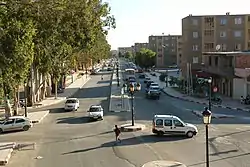
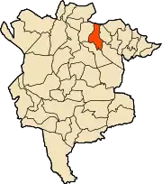
M'Sila, Algeria
M'sila (also spelled Msila) (Arabic: المسيلة); is the capital of M'Sila Province, Algeria, and is co-extensive with M'sila District. It has a population of 132975 as per the 2008 census.[1] M'sila University is also located in this city.
M'sila
المسيلة | |
|---|---|
 Overview of M'sila | |
 | |
 M'sila | |
| Coordinates: 35°42′7″N 4°32′49″E | |
| Country | |
| Province | M'Sila Province |
| District | M'Sila District |
| Elevation | 471 m (1,545 ft) |
| Population (2008 census) | |
| • Total | 132,975 |
| Time zone | UTC+1 (CET) |
History
M'sila was the location of the first village constructed as part of a government-run program to transition nomadic Algerians to sedentary life using local materials. The village, now complete, was dubbed Maader and consists of houses, public and trading areas, and a mosque. Today it is much more developed with many companies, business offices, religious centers and schools.
Climate
M'sila has a cold semi-arid climate (Köppen climate classification BSk). Rainfall is higher in winter than in summer. The average annual temperature in M'Sila is 15.8 °C (60.4 °F). About 229 mm (9.02 in) of precipitation falls annually.
| Climate data for M'Sila | |||||||||||||
|---|---|---|---|---|---|---|---|---|---|---|---|---|---|
| Month | Jan | Feb | Mar | Apr | May | Jun | Jul | Aug | Sep | Oct | Nov | Dec | Year |
| Average high °C (°F) | 12.8 (55.0) |
13.9 (57.0) |
16.5 (61.7) |
19.6 (67.3) |
23.0 (73.4) |
27.1 (80.8) |
30.7 (87.3) |
30.7 (87.3) |
27.1 (80.8) |
22.3 (72.1) |
17.3 (63.1) |
14.1 (57.4) |
21.3 (70.3) |
| Average low °C (°F) | 4.1 (39.4) |
4.6 (40.3) |
6.3 (43.3) |
8.1 (46.6) |
11.0 (51.8) |
14.7 (58.5) |
17.2 (63.0) |
17.4 (63.3) |
15.7 (60.3) |
11.9 (53.4) |
8.2 (46.8) |
5.3 (41.5) |
10.4 (50.7) |
| Average precipitation mm (inches) | 25 (1.0) |
15 (0.6) |
25 (1.0) |
17 (0.7) |
26 (1.0) |
12 (0.5) |
5 (0.2) |
5 (0.2) |
21 (0.8) |
22 (0.9) |
34 (1.3) |
22 (0.9) |
229 (9.0) |
| Source: Climate-Data.org,Climate data | |||||||||||||
Economy
M'sila is primarily known for its farming and small business.
External links
- Encycloepaedia of the Orient-a brief description of M'Sila, focusing on its capital
- BBC - a news article about some recent violence in M'Sila
- Archnet - focuses on the Maader village project
- Wetlands International - an in-depth description of M'Sila's wetland
.svg.png.webp)
| Wikimedia Commons has media related to M'Sila. |