MAX Orange Line
The MAX Orange Line is part of the MAX Light Rail service that is operated by TriMet in Portland, Oregon, United States. The MAX Orange Line connects Portland City Center south to Portland State University (PSU), Southeast Portland, Milwaukie, and Oak Grove. The service begins near Portland Union Station and runs southbound along the Portland Transit Mall on 5th Avenue. From there, it operates the 7.3-mile (11.7 km) Portland–Milwaukie Light Rail segment through the South Waterfront, across the Willamette River into Southeast Portland, then south to Oak Grove just outside Milwaukie proper in unincorporated Clackamas County. The line serves 17 stations between Union Station/Northwest 5th & Glisan and Southeast Park Avenue. The service is run for 201⁄2 hours daily with a minimum headway of 15 minutes during most of the day.
The Portland–Milwaukie Light Rail Project was the second part of the two-phased South Corridor Transportation Project that in its first phase expanded light rail services to Interstate 205 (I-205) and the Portland Transit Mall. This MAX extension, which followed years of failed light rail plans for Clackamas County, began construction work in mid-2011. As part of the project, TriMet built Tilikum Crossing over the Willamette River, the first major "car-free" bridge in the United States. The extension opened to Orange Line service on September 12, 2015, and by September 2019, it carried an average of 11,500 daily weekday riders.
The Orange Line operates as a southbound through service of the Yellow Line from Union Station/Northwest 5th & Glisan station, sharing its transit mall alignment on 5th Avenue with the Green Line. From PSU South/Southwest 6th and College station, the Orange Line through-operates into the Yellow Line as a northbound service of the transit mall on 6th Avenue and terminates at Expo Center station in North Portland.
History
Early proposals to Clackamas County
In 1975, the Columbia Region Association of Governments (CRAG) proposed a series of "transitway" corridors in the Portland metropolitan area amid calls to transfer federal assistance funds from the canceled Mount Hood Freeway project to other projects in the region.[5][6] This proposal, which CRAG adopted in an interim transportation plan, primarily envisioned buses serving these corridors and also proposed a single light rail corridor running from downtown Portland to Oregon City in Clackamas County with a spur line running from Milwaukie to Lents, both primarily running along old Portland Traction Company rights-of-way.[7] Indecision about the exact use of the transfer money, as requested by the Federal Highway Administration,[8] led to a delay in acquiring the funds.[9][10] That November, the regional transit agency TriMet lost its option to purchase used PCC streetcars, which it had hoped to use on the proposed Portland–Oregon City line, from Toronto[11] after the Toronto Transit Commission declined to renew TriMet's hold.[12]
The following year, the Portland City Council separately approved the addition of a busway component to I-205, a freeway that had been under construction in Portland's east side;[13] this bus corridor, which would be called the I-205 Transitway, ran physically separate from but parallel to the freeway.[14] The I-205 Transitway's realization led TriMet to prioritize development of the Banfield Transitway,[15]:31 a similarly planned stretch of I-84 connecting I-5 in downtown Portland east to I-205.[16]:ii The Banfield Transitway Project, which was originally proposed as another busway,[17] was allocated the transfer funds but was ultimately built with light rail.[18][19] Portland's first light rail line—the first segment of the Metropolitan Area Express (MAX)—began operating between Gresham and Portland on September 5, 1986.[20]
Several months before the inauguration of MAX, regional government Metro—the successor to CRAG—renewed talks about extending light rail from Portland to Milwaukie and to Oregon City via McLoughlin Boulevard, as well as a proposed conversion of the I-205 Transitway between Portland International Airport and Clackamas Town Center into another light rail line.[21] During this time, TriMet had already been planning for a westside extension of MAX to Hillsboro in Washington County, which the agency wanted to prioritize.[22] Noting federal funds could only be spent on one light rail project at a time, Metro's Joint Policy Advisory Committee on Transportation (JPACT) made the I-205 light rail line its second priority due to the existing I-205 Transitway right-of-way, and the McLoughlin Boulevard line became its third priority.[23] Despite this, Clackamas and Washington counties argued over the federal money.[24][25] To settle the dispute, Metro released a regional transportation plan (RTP) that reasserted the Westside line's priority in January 1989.[26]
Failed South/North Line
.jpg.webp)
Metro's RTP commissioned studies for the I-205 and McLoughlin Boulevard light rail proposals.[26][27] In September 1989, Oregon Senator Mark Hatfield and Washington Senator Brock Adams, who were members of the U.S. Senate Committee on Appropriations, helped get a $2 million financing package from the federal government to assess both segments approved. At the request of the two senators, a segment further north to Vancouver and Clark County in Washington became part of the proposals.[28][29] As the studies analyzed alternative routes, the project's advisory committee increasingly favored an alignment closer to downtown Portland along the busier I-5 and Willamette River corridors.[30] In 1994, Metro finalized a 25-mile (40 km) route from Hazel Dell, Washington, through downtown Portland to Clackamas Town Center, which TriMet officially called the "South/North Line".[31][32]:80
That November, "nearly two-thirds" of Oregonian voters in the Portland metropolitan area voted in support of a $475 million bond measure to provide Oregon's local-area share of the project's estimated $2.8 billion cost.[33] Three months later, 69 percent of voters in Clark County rejected increases in sales and vehicle excise taxes that would have provided that county's $237.5 million share.[34][35] Planning for the South/North Line later resumed when TriMet released a revised project that scaled back the line's northern half to the Rose Quarter and eliminated its North Portland and Clark County segments.[36] To fill the funding gap that resulted from the exclusion of Clark County, the Oregon House of Representatives passed a $750 million transportation package that included $375 million for the project.[37] The Oregon Supreme Court promptly struck down this funding due to the inclusion of unrelated measures, which violated the state's constitution.[38][39] In February 1996, state legislators revised the package[38] but in November, light-rail opponents forced a statewide vote that prevented the use of state funds.[40]
In February 1997, in an effort to regain the support of North Portland residents, who had historically voted in favor of light rail, and to avoid seeking state funding,[41] TriMet announced a third plan that proposed a 15-mile (24 km) line from Lombard Street in North Portland to Clackamas Town Center.[42] Portland City Council later extended this alignment through North Portland; it would have terminated another mile north of Lombard Street in Kenton.[43] In August, due to the wording on the original ballot passed in 1994, which described the line extending into Clark County, the TriMet board elected to reaffirm voter support by drafting a new $475 million bond measure.[44] Portland area residents voted on the measure on November 3, 1998, and narrowly rejected it by 52 percent, effectively canceling the project.[45] Despite the project's rejection, North Portland residents and city business leaders continued to push for light rail.[46][47] In 1999, they urged TriMet to revive the northern portion of the South/North Line,[48] which led to the Interstate MAX extension opening in 2004.[49][50]
Revival and funding

In May 2001, JPACT revisited transit plans for I-205 and McLoughlin Boulevard, and the following month announced the $8.8 million South Corridor transportation study, which evaluated mode alternatives for each corridor.[51][52] In 2003, the committee selected five alternatives, which included building both light rail lines, a combination of a light rail service and an improved bus service, bus rapid transit, and dedicated bus lanes.[53] After public meetings, they recommended building both light rail options.[54] JPACT decided the first MAX line to Clackamas County should be built along the I-205 Transitway from Gateway to Clackamas Town Center, and that this would be the first phase of a two-part expansion, the second phase of which would be a Portland–Milwaukie line.[55] They later amended the first phase to include an extension of light rail along the Portland Transit Mall when planning for the second phase revealed a fourth service along the existing downtown tracks on Morrison and Yamhill streets, which was already served by the Blue, Red, and Yellow lines, would push that alignment to maximum capacity.[56]:P-2[57] In August 2009, the transit mall reopened with light rail service from the newly rerouted Yellow Line.[58] The I-205 MAX extension opened the following month with service from the Green Line.[59][60]
Meanwhile, planning for the Portland–Milwaukie line, including the study of and public input on several alternatives for the exact route, continued. In July 2008, Metro adopted a locally preferred alternative (LPA) alignment that originated at the southern end of the Portland Transit Mall and terminated at Southeast Park Avenue in Oak Grove, just south of Milwaukie proper in unincorporated Clackamas County rather than at Southeast Lake Road in downtown Milwaukie as had been planned in 2003.[61]:3,5 The LPA also reaffirmed decade-long calls for a new bridge that would carry MAX and the Portland Streetcar over the Willamette River rather than using the Hawthorne Bridge.[62][63] The new bridge was originally planned to run between RiverPlace on the west end and the Oregon Museum of Science and Industry (OMSI) on the east end but the LPA introduced several new alternatives that moved its west end farther south in the South Waterfront.[61]:6–9 TriMet designed the bridge to be "car-free", bannin private vehicles and accommodating only transit vehicles, bicycles, and pedestrians—the first such major bridge in the U.S.[64][65]
The Portland–Milwaukie Light Rail Project was budgeted at $1.49 billion (equivalent to $1.6 billion in 2019 dollars), of which federal funding covered $745.18 million under the New Starts program.[66] Despite TriMet's request for a 60-percent federal share, the Federal Transit Administration (FTA) only committed 50 percent to the total cost, lower than any previous MAX project.[67] Oregon provided the second-largest share at $355.2 million, which was mostly sourced from state lottery bond proceeds. Metro, TriMet, Clackamas County, Portland, Milwaukie, and in-kind property donations contributed $249.33 million to the remaining local-match funds. TriMet and the FTA entered into a funding agreement in May 2012.[66] Clackamas County had originally agreed to allocate $25 million to the project but that August it negotiated a reduction to $22.6 million amid the placement of Measure 3-401,[68] an anti-light-rail initiative, by light rail opponents in a special election ballot. The measure stipulated voter approval before officials could spend funds to finance, design, construct, or operate rail lines in the county.[69] On September 18, Measure 3-401 passed with 60 percent of the vote.[70] After the vote, Clackamas County attempted to end its involvement with the project, appealing to TriMet to terminate the extension at Southeast Tacoma/Johnson Creek station, just north of the county line. TriMet filed a lawsuit, and in July 2013, a circuit court upheld the county's financial obligation and the project's continuation.[15]:95–96
Construction and opening
On April 5, 2011, the FTA approved the start of the Portland–Milwaukie line's final design,[71][72] which meant TriMet could begin purchasing right-of-way and construction materials.[71] Construction began later on June 30; it was initially limited to the site of the new Willamette River crossing,[73] which was temporarily named the "Portland–Milwaukie Light Rail Bridge".[74] Right-of-way preparation work, including utility relocation, began later that year.[75][76] By 2013, major light-rail construction work had started in Clackamas County.[77] As part of construction, safety improvements were made at several street-level crossings in Southeast Portland and Milwaukie, allowing them to be designated quiet zones where freight and MAX trains do not have to use their horns when crossing an intersection.[78] By that July, the project had been completed by 50 percent.[79] In April 2014, TriMet officially named the new bridge "Tilikum Crossing, Bridge of the People", which it selected from over 9,500 public submissions.[80] The agency also purchased 18 new Siemens S70 vehicles to serve the expansion; these were designated "Type 5" and the first car arrived in Portland that September.[81] When construction finished the following year, the line was up to $40 million under budget. A petition from Senator Jeff Merkley led the FTA to approve the addition of switch heaters, catenary ice caps, and additional station shelters, totaling $3.6 million.[82]
On May 15, 2015, the first trips with around 500 passengers, including Governor Kate Brown and Senator Merkley, ran at regular operating speed along the entirety of the 7.3 miles (11.7 km) Portland–Milwaukie extension.[83] On August 30, test trains began running along the entire Orange Line route, ahead of the following month's opening date.[84] The extension opened for service on September 12 at 11 am.[85][86] The Orange Line became interlined with and took over the Yellow Line's southbound 5th-Avenue segment of the Portland Transit Mall. TriMet said separating the lines would allow it to better control service frequencies from North Portland and Milwaukie to downtown Portland because it expected higher ridership of the Orange Line and that few riders from these communities would travel beyond the city center.[87]
Route
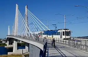
.jpg.webp)
The Orange Line serves the 7.3-mile (11.7 km)-longPortland–Milwaukie extension.[lower-alpha 1] Service begins near Portland Union Station at Union Station/Northwest 5th & Glisan station, where southbound Yellow Line trains through-operate into the Orange Line to serve the southbound 5th Avenue segment of the Portland Transit Mall. Northward, the Yellow Line serves the 6th Avenue segment as through-routed continuations of northbound Orange Line trains.[88] Just south of the PSU South stations, the tracks travel east along the median of Southwest Lincoln Street to a stop on 3rd Avenue, from where the line continues east along Lincoln to an elevated viaduct at an intersection with Naito Parkway.[89] The viaduct carries the line over Harbor Drive and River Parkway to South Waterfront/Southwest Moody station, where tracks merge with those of the Portland Streetcar's Loop Service, and then across the Willamette River on Tilikum Crossing.[90][91]
On the opposite end of Tilikum Crossing, the streetcar tracks diverge and Orange Line trains stop at OMSI/Southeast Water station. The tracks then turn southeast and run parallel to the Union Pacific Railroad,[92][93] making an intermediate stop at Clinton Street/Southeast 12th Avenue station.[94] At Southeast 17th Avenue, the line turns south and runs along the median of 17th Avenue with stops at Holgate Boulevard and Rhine Street.[95] It exits the median just north of McLoughlin Boulevard and runs parallel to this road, and Portland and Western and Union Pacific rights-of-way through to Milwaukie.[96]:15–16 After a stop at Milwaukie/Main Street station in downtown Milwaukie,[97] the line enters Kellogg Bridge, an elevated viaduct that carries the line across Kellogg Lake to 22nd Avenue.[90] From here, the tracks leave the viaduct and again travel at grade alongside McLoughlin Boulevard to a three-track stub terminal at Park Avenue and McLoughlin Boulevard in Oak Grove, just south of Milwaukie proper.[98][99]
Stations
.jpg.webp)
_-_4.jpg.webp)
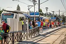
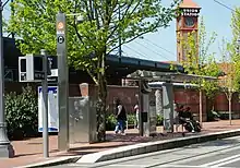
The Portland–Milwaukie extension consists of ten stations between Lincoln Street/Southwest 3rd Avenue and Southeast Park Avenue, of which two are within Clackamas County: Milwaukie/Main Street in downtown Milwaukie and Southeast Park Avenue in Oak Grove. The Orange Line is the only service that serves the Portland–Milwaukie segment. It also serves seven stations in downtown Portland along the southbound segment of the Portland Transit Mall on 5th Avenue; these are shared with the Green Line. Transfers to the Yellow Line, which runs northbound from PSU South in downtown Portland to the Expo Center, can be made at any of the seven stations along the Transit Mall's 6th-Avenue alignment, although most northbound Orange Line trains through-operate into the Yellow Line. Transfers to the Blue Line and the Red Line are available at Pioneer Place/Southwest 5th station. The Orange Line also provides connections to local and intercity bus services at several stops; Amtrak near Union Station/Northwest 5th & Glisan station,[88] and the Portland Streetcar at the PSU Urban Center/Southwest 5th & Mill and OMSI/Southeast Water stations.[100]
In 2015, TriMet proposed installing turnstiles through which passengers would access paid fare zones within the Southeast Bybee Boulevard and Southeast Park Avenue stations as part of a future pilot program to test the Hop Fastpass automated fare collection system. As of 2020, these plans have not been enacted.[101]
| Key | |
|---|---|
| † | Terminus |
| ↓ | Southbound travel only |
| Station | Location | Commenced | Line transfers[102] | Other connections and notes[102][88][lower-alpha 2] |
|---|---|---|---|---|
| Union Station/Northwest 5th & Glisan†↓ | Portland Transit Mall [lower-alpha 3] |
September 12, 2015 | ||
| Northwest 5th & Couch↓ | — | |||
| Southwest 5th & Oak↓ | — | |||
| Pioneer Place/Southwest 5th↓ | Serves the Pioneer Courthouse, Pioneer Courthouse Square | |||
| City Hall/Southwest 5th & Jefferson↓ | — | |||
| PSU Urban Center/Southwest 5th & Mill↓ | ||||
| PSU South/Southwest 5th and Jackson↓ | Serves Portland State University | |||
| Lincoln Street/Southwest 3rd Avenue | Portland | — | — | |
| South Waterfront/Southwest Moody | — | |||
| OMSI/Southeast Water | — | |||
| Clinton Street/Southeast 12th Avenue | — | — | ||
| Southeast 17th Avenue and Rhine Street | — | — | ||
| Southeast 17th Avenue and Holgate Boulevard | — | — | ||
| Southeast Bybee Boulevard | — | — | ||
| Southeast Tacoma/Johnson Creek | — | — | ||
| Milwaukie/Main Street | Milwaukie | — | — | |
| Southeast Park Avenue† | — | — | ||
Service
.jpg.webp)
As of October 2020, the Orange Line operates for approximately 201⁄2 hours per day on weekdays; the first train arrives as a southbound service at Union Station/Northwest 5th & Glisan station at 5:02 am. The first northbound train departs Southeast Park Avenue station at 6:14 am. End-to-end travel takes approximately 35 minutes.[103] During peak hours, some Orange Line trains do not become Yellow Line trains; they loop back along the Transit Mall and return to Milwaukie. This is due to higher projected ridership along the Orange Line than the Yellow Line.[87] The last Milwaukie-bound train departs Union Station/Northwest 5th & Glisan station at 12:02 am and the last Portland City Center-bound train departs Southeast Park Avenue station at 12:56 am. Fewer trains run during weekends.[103] TriMet designates the Orange Line as a "Frequent Service" route, running on a headway of 15 minutes during most of the day, which extends up to 30 minutes in the early mornings and late evenings.[104] In the late evenings, the Orange Line is supplemented by TriMet bus route 291–Orange Night Bus, which runs south from downtown Portland to Milwaukie following the Orange Line route. Two trips run on weekdays and one trip runs on Saturdays and Sundays.[105][106]
Ridership
The Orange Line is the least-busy MAX service, averaging 11,500 riders on weekdays in September 2019,[2] down from 11,750 for the same month in 2018.[107] Forecasts that were used to help justify federal funding for the project predicted an average of 17,000 weekday trips in 2016 but by October of that year, the Orange Line had served fewer than 11,000.[108]
Explanatory notes
- TriMet publications only provide the total length of the Portland–Milwaukie extension, i.e., the 7.3-mile (11.7 km) section that was newly built. The total length of Orange Line service, which includes a segment of the Portland Transit Mall, is undetermined.[3]:4
- This list of service connections excludes TriMet bus connections. For a complete list that includes all transfers, see: List of MAX Light Rail stations.
- Most Orange Line trains on the Portland Transit Mall travel southbound only. Most northbound trains through operate into the Yellow Line bound for Expo Center in North Portland at PSU South/Southwest 6th and College.
References
- "PMLR Project History". TriMet. Archived from the original on March 2, 2019. Retrieved September 27, 2020.
- "September 2019 Monthly Performance Report" (PDF). TriMet. Archived (PDF) from the original on April 26, 2020. Retrieved January 9, 2020.
- "Portland–Milwaukie MAX Orange Line" (PDF). TriMet. July 2016. Archived (PDF) from the original on April 23, 2019. Retrieved May 14, 2019.
- Simons, Vic (December 2015). "Portland: Green meets Orange". Tramways & Urban Transit. UK: LRTA Publishing. pp. 473–478. ISSN 1460-8324.
- "Meetings on transit ideas slated". The Oregonian. May 4, 1975. p. C2. Retrieved April 25, 2020 – via NewsBank.
- Hortsch, Dan (September 28, 1975). "Mt. Hood Freeway may be dead – but it's still kicking". The Sunday Oregonian. p. D1. Retrieved April 25, 2020 – via NewsBank.
- Hortsch, Dan (September 28, 1975). "Transferred money would go toward multiplicity of confusing projects". The Oregonian. p. D1. Retrieved April 25, 2020 – via NewsBank.
- "Freeway fund report delayed". The Oregonian. December 19, 1975. p. F8.
- Mosey, Ed (January 8, 1976). "Delay urged in deciding use of Mt. Hood freeway funds". The Oregonian. p. A24.
- Hortsch, Dan (January 23, 1976). "Shift of freeway funds stirs complex situation". The Oregonian. p. A15.
- "Bus firm OKs option to buy 15 old streetcars". The Oregonian. May 7, 1974. p. 6.
- Hobart, Sue (November 30, 1975). "Tri-Met loses option to buy used streetcars". The Oregonian. p. D6. Retrieved April 25, 2020 – via NewsBank.
- Collins, Huntly (June 4, 1976). "City Council OKs I-205 completion". The Oregonian. p. B1.
- "Tri-Met board okays I-205 busway concept". The Oregonian. February 3, 1976. p. A8. Retrieved April 25, 2020 – via NewsBank.
- Selinger, Philip (October 2019). "Making History: 50 Years of Transit in the Portland Region" (PDF). TriMet. Archived from the original (PDF) on February 25, 2020. Retrieved February 25, 2020.
- United States. Federal Highway Administration; United States. Urban Mass Transportation Administration; Oregon. State Highway Division (August 1980). Banfield Transitway Project: Light Rail Transit Line and Banfield Freeway Improvements: Final Environmental Impact Statement (Report). TriMet Collection. Archived from the original on January 5, 2021. Retrieved June 12, 2020.
- "Meetings on transit ideas slated". The Oregonian. May 4, 1975. p. C2.
- Hortsch, Dan (September 27, 1978). "Tri-Met board votes to back Banfield light-rail project". The Oregonian. p. F1.
- Alesko, Michael (November 17, 1978). "CRAG endorses light rail plan". The Oregonian. p. D3.
- Federman, Stan (September 5, 1986). "All aboard! MAX on track; ride free". The Oregonian. p. 1.
- "Where's east side light rail going next?". The Oregonian. April 3, 1986. p. 2.
- Kohler, Vince (May 23, 1988). "Joint efforts of business, government could spur rail line; both groups need to finance, back line along I-205, panel says". The Oregonian. p. B5.
- Bodine, Harry (October 27, 1987). "Panel puts top priority on mass transit, major highway projects". The Oregonian. p. B4.
- Green, Ashbel (October 6, 1988). "County officials debate light-rail routes". The Oregonian. p. W1.
- Kohler, Vince (January 17, 1991). "Clackamas County seeks federal money for rail line". The Oregonian. p. C2.
- Bodine, Harry (January 14, 1989). "Metro OKs $1.5 billion transit plan". The Oregonian. p. D1.
- Mayer, James (April 9, 1989). "Tri-Met looks to the future: The success of MAX sparks dreams of expanding". The Oregonian. p. A1.
- Kohler, Vince; Stewart, Bill (September 10, 1989). "Light-rail proposals gain ground in Congress; senate panel approves transportation funding bill, aiding plans for new Oregon City, Vancouver lines". The Oregonian. p. C2.
- Stewart, Bill (January 12, 1993). "County light-rail project gains momentum". The Oregonian. p. B2.
- Oliver, Gordon (March 11, 1993). "Citizens advisory committee endorses pair of light-rail routes". The Oregonian. p. B3.
- Maves, Norm Jr. (October 27, 1994). "25-mile route encompasses hundreds of steps". The Oregonian. p. 1. Retrieved April 27, 2020 – via NewsBank.
- Selinger, Philip (2015). "Making History: 45 Years of Transit in the Portland Region" (PDF). TriMet. pp. 80, 83–85. OCLC 919377348. Archived from the original on May 9, 2018. Retrieved July 26, 2018.CS1 maint: unfit URL (link)
- Oliver, Gordon (November 10, 1994). "One down, more to go for reality of north–south rail line". The Oregonian. p. C10. Retrieved April 27, 2020 – via NewsBank.
- Oliver, Gordon (February 8, 1995). "Clark County turns down north–south light rail". The Oregonian. p. 1. Retrieved April 27, 2020 – via NewsBank.
- Oliver, Gordon (February 9, 1995). "Light-rail rejection stirs doubt on project". The Oregonian. p. C1. Retrieved April 27, 2020 – via NewsBank.
- Oliver, Gordon; Stewart, Bill (March 1, 1995). "MAX may skip Clark County, N. Portland". The Oregonian. p. B1. Retrieved April 27, 2020 – via NewsBank.
- Green, Ashbel S.; Mapes, Jeff (August 4, 1995). "Legislature is finally working on the railroad". The Oregonian. p. A1.
- "Some light-rail history". The Oregonian. October 7, 1996. p. A8.
- Spicer, Osker (January 31, 1996). "Light-rail would be good for areas". The Oregonian. p. C2.
- Oliver, Gordon; Hunsenberger, Brent (November 7, 1996). "Tri-Met still wants that rail line to Clackamas County". The Oregonian. p. D1. Retrieved April 27, 2020 – via NewsBank.
- Oliver, Gordon (February 12, 1997). "South–North light-rail issue keeps on going". The Oregonian. p. A1. Retrieved April 27, 2020 – via NewsBank.
- Oliver, Gordon (February 12, 1997). "Returning to light rail". The Oregonian. p. A20. Retrieved April 27, 2020 – via NewsBank.
- Stewart, Bill (June 19, 1998). "Portland officially maps a South–North rail line". The Oregonian. p. B3. Retrieved April 27, 2020 – via NewsBank.
- Oliver, Gordon (August 6, 1998). "Tri-Met will put rail plan on ballot". The Oregonian. p. B1. Retrieved April 27, 2020 – via NewsBank.
- Oliver, Gordon (November 7, 1998). "South–North Line backers find themselves at a loss after election day defeat". The Oregonian. p. B1. Retrieved April 27, 2020 – via NewsBank.
- Oliver, Gordon (March 16, 1999). "New light-rail plan rises from the ashes". The Oregonian. p. 1. Retrieved April 29, 2020 – via NewsBank.
- Stewart, Bill (March 25, 1999). "Tri-Met involvement urged in north light-rail line". The Oregonian. p. B3. Retrieved April 29, 2020 – via NewsBank.
- Oliver, Gordon (May 3, 1999). "Tri-Met adds detail to proposal to build light rail in north". The Oregonian. p. C2. Retrieved April 29, 2020 – via NewsBank.
- Leeson, Fred (April 25, 2004). "The Yellow Line: Open for business". The Oregonian. p. B5. Retrieved April 29, 2020 – via NewsBank.
- Leeson, Fred (May 4, 2004). "Yellow Line: They came, they rode, they offered opinions". The Oregonian. p. B1. Retrieved April 29, 2020 – via NewsBank.
- Rose, Joseph (May 8, 2001). "New MAX plan tries to the double-team approach". The Oregonian. p. D1.
- Rose, Joseph (June 6, 2001). "Metro planners will study two south light-rail lines". The Oregonian. p. E3.
- Oppenheimer, Laura (January 27, 2003). "New MAX plans arrive for input; a revived bid to expand light rail to Milwaukie, one of five transit proposals, may fare better now that former critics are on board". The Oregonian. p. E1.
- Oppenheimer, Laura (February 17, 2003). "South Corridor MAX plan unveiled". The Oregonian. p. E1.
- Leeson, Fred (March 27, 2003). "TriMet board agrees to plan for southeast light-rail lines". The Oregonian. p. C2.
- United States Department of Transportation (October 2003). Downtown Amendment to the South Corridor Project Supplemental Environmental Impact Statement (Report). Archived from the original on January 5, 2021. Retrieved June 25, 2019.
- Leeson, Fred (April 15, 2003). "Light-rail line likely addition to transit mall". The Oregonian. p. B1.
- "New MAX line opens downtown". Portland Tribune. August 28, 2009. Archived from the original on January 3, 2015. Retrieved May 13, 2014.
- Rivera, Dylan (September 13, 2009). "Thousands on MAX go Green Festivities and free rides draw takers for the new downtown–Clackamas Town Center line". The Oregonian.
- Rivera, Dylan (September 13, 2009). "Riders pack MAX Green Line on first day of service". The Oregonian. Archived from the original on September 22, 2009. Retrieved September 20, 2009.
- South Corridor Portland–Milwaukie Light Rail Project Locally Preferred Alternative Report (PDF) (Report). Metro. July 24, 2008. Archived from the original (PDF) on March 2, 2019. Retrieved September 26, 2020.
- McCarthy, Dennis (December 20, 2001). "Milwaukie group poses surprise light-rail option". The Oregonian. p. C3.
- Mortenson, Eric (May 2, 2008). "Panel realigns route of new light-rail span". The Oregonian. p. D1.
- Rose, Joseph (December 8, 2010). "TriMet board gives greenlight to Portland-Milwaukie Light Rail bridge funding". The Oregonian. Archived from the original on January 5, 2021. Retrieved September 29, 2020.
- Libby, Brian (October 2015). "Bridge to the Future (The Bridge that Bans Cars)". The Atlantic. 316 (3): 42–43. Archived from the original on 2020-04-29. Retrieved September 27, 2015.
- "Portland-Milwaukie Light Rail Project Portland, Oregon" (PDF). Federal Transit Administration. December 2017. Archived (PDF) from the original on January 5, 2021. Retrieved September 28, 2020.
- Rose, Joseph (July 26, 2010). "Feds say Portland-Milwaukie MAX line must settle for 50-50 funding". The Oregonian. Archived from the original on January 5, 2021. Retrieved September 30, 2020.
- Zheng, Yuxing (August 24, 2012). "County OKs controversial funding for light-rail line". The Oregonian. Retrieved October 1, 2020 – via NewsBank.
- Zheng, Yuxing (June 9, 2012). "County looks at ways to fight MAX measure". The Oregonian. Retrieved October 1, 2020 – via NewsBank.
- Zheng, Yuxing (September 18, 2012). "Clackamas County anti-rail measure passes comfortably; effect could resonate for decades". The Oregonian. Retrieved February 22, 2016.
- "Portland light rail extension starts final design". Railway Gazette International. April 5, 2011. Archived from the original on April 5, 2011. Retrieved April 5, 2011.
- Rose, Joseph (March 29, 2011). "Feds approve design for Portland-Milwaukie light rail line". The Oregonian. Archived from the original on January 5, 2021. Retrieved April 5, 2011.
- Rose, Joseph (June 29, 2011). "Construction begins on new light-rail bridge in Portland that will go up 'piece by piece'". The Oregonian. Archived from the original on January 5, 2021. Retrieved July 27, 2013.
- "Portland–Milwaukie Light Rail Bridge Fact Sheet" (PDF). TriMet. August 2012. Archived (PDF) from the original on January 5, 2021. Retrieved July 27, 2013.
- Fehrenbacher, Lee (July 5, 2012). "Portland-Milwaukie Light Rail project construction passes 1-year mark". Daily Journal of Commerce. Archived from the original on January 5, 2021. Retrieved October 2, 2020.
- "Portland-Milwaukie light rail construction to impact traffic". The Oregonian. October 8, 2012. Archived from the original on January 5, 2021. Retrieved October 2, 2020.
- Bamesberger, Michael (March 23, 2013). "It's the year of heavy light rail construction in Clackamas County". The Oregonian. Archived from the original on January 5, 2021. Retrieved October 2, 2020.
- "Stay safe near the new MAX Orange Line" (PDF). TriMet. Archived (PDF) from the original on January 5, 2021. Retrieved April 5, 2015.
- Rose, Joseph (July 26, 2013). "TriMet announces opening date for Portland-Milwaukie light rail line". The Oregonian. p. B3. Archived from the original on January 5, 2021. Retrieved July 27, 2013.
- Rose, Joseph (April 16, 2014). "Tilikum Crossing: New Portland bridge named after Chinook word for 'people'". The Oregonian. Archived from the original on January 5, 2021. Retrieved April 16, 2014.
- Rose, Joseph (September 30, 2014). "TriMet's first new 'Type 5' MAX light-rail vehicle has rolled into Portland (or has it?)". The Oregonian. Archived from the original on January 5, 2021. Retrieved October 2, 2020.
- Fetsch, Mary (March 27, 2015). "MAX Orange Line – on time and under budget". TriMet. Archived from the original on July 25, 2018. Retrieved April 5, 2015.
- Tomlinson, Stuart (May 15, 2015). "Gov. Kate Brown, 500 others are first passengers on MAX's new Orange line". The Oregonian. Retrieved May 18, 2015.
- "MAX Orange Line to begin test runs". Trains. August 28, 2015. Archived from the original on January 5, 2021. Retrieved August 29, 2015.
- "Fall 2015 Service Improvements". TriMet. August 2015. Archived from the original on September 27, 2015. Retrieved September 1, 2015.
- Njus, Elliot (September 12, 2015). "The wait's over: TriMet's Orange Line, Tilikum Crossing up and running". The Oregonian. Archived from the original on August 1, 2018. Retrieved September 18, 2015.
- Lum, Brian (June 19, 2015). "You asked: How will the Orange Line work in downtown Portland?". TriMet. Archived from the original on October 26, 2015.
- Portland City Center and Transit Mall (PDF) (Map). TriMet. Archived from the original (PDF) on July 2, 2020. Retrieved July 30, 2018.
- "Lincoln Street/SW 3rd Ave Station". TriMet. October 2014. Archived from the original on January 5, 2021. Retrieved October 2, 2020.
- "Portland–Milwaukie Light Rail Transit Project Structures" (PDF). TriMet. October 2013. Archived (PDF) from the original on January 5, 2021. Retrieved May 17, 2020.
- "South Waterfront/SW Moody Ave Station". October 2014. Archived from the original on January 5, 2021. Retrieved October 2, 2020.
- Google (January 20, 2020). "45°29'55.9"N 122°38'53.6"W" (Map). Google Maps. Google. Retrieved January 20, 2020.
- Google (January 20, 2020). "OMSI/SE Water MAX Station" (Map). Google Maps. Google. Retrieved January 20, 2020.
- "Clinton/SE 12th Ave Station". TriMet. October 2014. Archived from the original on January 5, 2021. Retrieved May 17, 2020.
- "SE 17th Avenue: Holgate Boulevard and Rhine Street stations". TriMet. October 2014. Archived from the original on January 5, 2021. Retrieved May 17, 2020.
- Portland-Milwaukie Light Rail Project Locally Preferred Alternative Report (PDF) (Report). Metro. July 24, 2008. Archived (PDF) from the original on March 2, 2019. Retrieved May 17, 2020.
- "Milwaukie/Main Street station area". TriMet. October 2014. Archived from the original on January 5, 2021. Retrieved May 17, 2020.
- "SE Park Ave Station Area" (PDF). TriMet. October 2014. Archived (PDF) from the original on January 5, 2021. Retrieved May 18, 2020.
- Google (January 17, 2020). "SE Park Ave MAX Station" (Map). Google Maps. Google. Retrieved January 17, 2020.
- "Maps + Schedules - Portland Streetcar". Portland Streetcar. Archived from the original on February 10, 2019. Retrieved October 11, 2018.
- Rose, Joseph (March 20, 2015). "Fare turnstiles coming to Portland-Milwaukie MAX stations". The Oregonian. Archived from the original on January 5, 2021. Retrieved August 6, 2019.
- Rail System Map with transfers (PDF) (Map). TriMet. Archived from the original (PDF) on March 28, 2020. Retrieved July 25, 2018.
- MAX Orange Line schedules:
- For weekdays to Milwaukie: "MAX Orange Line, Weekday To Milwaukie" (PDF). TriMet. Archived (PDF) from the original on October 8, 2020. Retrieved October 8, 2020.
- For weekdays to Portland City Center: "MAX Orange Line, Weekday To Portland City Center" (PDF). TriMet. Archived (PDF) from the original on October 8, 2020. Retrieved October 8, 2020.
- For Saturday, to Milwaukie: "MAX Orange Line, Saturday To Milwaukie" (PDF). TriMet. Archived (PDF) from the original on October 8, 2020. Retrieved October 8, 2020.
- For Saturdays to Portland City Center: "MAX Orange Line, Saturday To Portland City Center" (PDF). TriMet. Archived (PDF) from the original on October 8, 2020. Retrieved October 8, 2020.
- For Sundays to Milwaukie: "MAX Orange Line, Sunday To Milwaukie" (PDF). TriMet. Archived (PDF) from the original on October 8, 2020. Retrieved October 8, 2020.
- For Sundays to Portland City Center: "MAX Orange Line, Sunday To Portland City Center" (PDF). TriMet. Archived (PDF) from the original on October 8, 2020. Retrieved October 8, 2020.
- "Frequent Service". TriMet. Archived from the original on January 9, 2019. Retrieved August 6, 2018.
- "291–Orange Night Bus". TriMet. Archived from the original on January 5, 2021. Retrieved October 8, 2020.
- 291–Orange Night Bus schedules:
- For weekdays: "291–Orange Night Bus, Weekday To Milwaukie" (PDF). TriMet. Archived (PDF) from the original on January 5, 2021. Retrieved October 8, 2020.
- For Saturdays: "291–Orange Night Bus, Saturday To Milwaukie" (PDF). TriMet. Archived (PDF) from the original on January 5, 2021. Retrieved October 8, 2020.
- For Sundays: "291–Orange Night Bus, Sunday To Milwaukie" (PDF). TriMet. Archived (PDF) from the original on January 5, 2021. Retrieved October 8, 2020.
- "September 2018 Monthly Performance Report" (PDF). TriMet. Archived (PDF) from the original on February 22, 2019. Retrieved October 8, 2020.
- Njus, Elliot (October 16, 2016). "Predicted riders not showing up". The Oregonian. p. A4. Retrieved October 1, 2020 – via NewsBank.
External links
| Wikimedia Commons has media related to MAX Orange Line. |