Madhubani district
Madhubani district is one of the thirty-eight districts of Bihar, India, and is a part of Darbhanga division. Its administrative headquarters are located in Madhubani. The district has an area of 3,501 square kilometres (1,352 sq mi) and has a population of 4,487,379 (as of 2011).
Madhubani district | |
|---|---|
District of Bihar | |
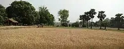 A field in Sugauna | |
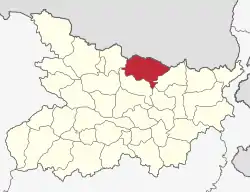 Location of Madhubani district in Bihar | |
| Country | |
| State | Bihar |
| Division | Darbhanga |
| Headquarters | Madhubani, India |
| Government | |
| • Lok Sabha constituencies | Madhubani, Jhanjharpur |
| • Vidhan Sabha constituencies | Harlakhi, Benipatti, Khajauli, Babubarhi, Bisfi, Madhubani, Rajnagar, Jhanjharpur, Phulparas, Laukaha |
| Area | |
| • Total | 3,501 km2 (1,352 sq mi) |
| Population (2011) | |
| • Total | 4,487,379 |
| • Density | 1,300/km2 (3,300/sq mi) |
| Demographics | |
| • Literacy | 60.9 per cent |
| • Sex ratio | 925 |
| Time zone | UTC+05:30 (IST) |
| Major highways | NH 104, NH 105 |
| Average annual precipitation | 1,273 mm |
| Website | madhubani |
History
| Year | Pop. | ±% p.a. |
|---|---|---|
| 1901 | 1,052,146 | — |
| 1911 | 1,058,313 | +0.06% |
| 1921 | 1,052,477 | −0.06% |
| 1931 | 1,143,713 | +0.83% |
| 1941 | 1,248,825 | +0.88% |
| 1951 | 1,361,699 | +0.87% |
| 1961 | 1,601,048 | +1.63% |
| 1971 | 1,892,039 | +1.68% |
| 1981 | 2,325,844 | +2.09% |
| 1991 | 2,832,024 | +1.99% |
| 2001 | 3,575,281 | +2.36% |
| 2011 | 4,487,379 | +2.30% |
| source:[1] | ||
Madhubani became a district in 1972 when it was split from Darbhanga district.[2] It is believed that Baliraajgadh, an archaeological site which lies in modern-day Madhubani district was the capital of the ancient Mithila Kingdom.[3]
Culture
Madhubani art or Mithila painting [4] was traditionally created by the women of various communities in Mithila region of India and Nepal. It originated from Madhubani district of Mithila region of Bihar, and, it is popularly called Mithila painting or Madhubani art. Madhubani is also a major export centre of these paintings.[5] This painting as a form of wall art was practiced widely throughout the region; the more recent development of painting on paper and canvas mainly originated among the villages around Madhubani, and it is these latter developments led to the name Madhubani art being used alongside the name "Mithila Painting."[6]
Geography
Madhubani district occupies an area of 3,501 square kilometres (1,352 sq mi),[7] comparatively equivalent to the Bahamas' North Andros island.[8] It occupies the Terai region.
Economy
In 2006 the Ministry of Panchayati Raj named Madhubani one of the country's 250 most backward districts (out of a total of 640).[9] It is one of the 38 districts in Bihar currently receiving funds from the Backward Regions Grant Fund Programme. But in last few years there a lot of changes happened. This city is going to adopt urbanisation.[9]
Places
Saurath, a road side village on Madhubani-Jainagar road, contains a temple known as Somnath Mahadev. It owes its importance to the annual Sabha held by Maithili Brahmins for negotiating marriages. Many Panjikars who keep the genealogical records of the different families reside here and outside.[10]
Laukaha is a Town in the district of Madhubani in the Indian state of Bihar. It is close to the border of Nepalese town of Thadi. Laukaha in India and Thadi in Nepal are a part of one of the agreed route for Mutual Trade between India and Nepal.[11] Nepal Government of Nepal has set up a dedicated customs office in the town.[12] and Government of India has set up a Land Customs Station with a Superintendent level officer.[13] So in simple Import and Export are allowed in this location.
Subdivisions
Madhubani District consists of five subdivisions. Each subdivision is headed by a subdivisional magistrate, who is responsible for law and order, development, and revenue related work in their respective subdivisions.[14]
- Madhubani Sadar
- Benipatti
- Jhanjarpur
- Phulparas
- Jainagar S
Blocks and circles
There are 21 blocks and circles in the district and each block is headed by a block development officer and each circle is headed by a circle officer.[15]
Demographics
At the time of the 2011 Census of India, 84.07% of the population in the district spoke Maithili, 12.86% Urdu and 3.01% Hindi as their first language.[16]
See also
References
- Decadal Variation In Population Since 1901
- Law, Gwillim (25 September 2011). "Districts of India". Statoids. Archived from the original on 17 October 2011. Retrieved 11 October 2011.
- https://hindi.news18.com/blogs/satyam/balirajharh-a-ancient-mithila-915917.html
- Madhubani Painting. 2003. ISBN 9788170171560.
- Madhubani Painting. Abhinav Publications. 30 September 2017. ISBN 9788170171560. Archived from the original on 21 February 2017 – via Google Books.
- Carolyn Brown Heinz, 2006, "Documenting the Image in Mithila Art," Visual Anthropology Review, Vol. 22, Issue 2, pp. 5-33
- Srivastava, Dayawanti et al. (ed.) (2010). "States and Union Territories: Bihar: Government". India 2010: A Reference Annual (54th ed.). New Delhi, India: Additional Director General, Publications Division, Ministry of Information and Broadcasting (India), Government of India. pp. 1118–1119. ISBN 978-81-230-1617-7.CS1 maint: extra text: authors list (link)
- "Island Directory Tables: Islands by Land Area". United Nations Environment Program. 18 February 1998. Archived from the original on 1 December 2015. Retrieved 11 October 2011.
North Andros Island 3,439km2
- Ministry of Panchayati Raj (8 September 2009). "A Note on the Backward Regions Grant Fund Programme" (PDF). National Institute of Rural Development. Archived from the original (PDF) on 5 April 2012. Retrieved 27 September 2011.
- "Archived copy". Archived from the original on 6 May 2018. Retrieved 6 May 2018.CS1 maint: archived copy as title (link)
- "India Nepal Trade Agreement. India-Nepal Foreign Treaty of Trade Agreement". www.eximguru.com. Retrieved 12 September 2019.
- "Department of Customs, Nepal - Custom Contact Offices". www.customs.gov.np. Retrieved 12 September 2019.
- http://www.cybex.in/Notifications/17-2012-Amends-Notification-63-1994-9672.aspx
- "Subdivision | Madhubani Administration". Retrieved 25 December 2018.
- "Blocks and Circles | Madhubani Administration". Retrieved 25 December 2018.
- 2011 Census of India, Population By Mother Tongue
External links
Places adjacent to Madhubani district | ||||||||||
|---|---|---|---|---|---|---|---|---|---|---|
| ||||||||||
| State symbols | |
|---|---|
| History |
|
| Administration |
|
| Overviews | |
| Divisions and districts | |
| Cities | |
| Municipal Corporation |
|
| Politics | |
| Culture | |