Bhagalpur district
Bhagalpur district is one of the thirty-eight districts of Bihar state, India, and Bhagalpur town is the administrative headquarters of this district. Most part of Bhagalpur district is in South Bihar.
Bhagalpur district | |
|---|---|
 An image of the river Ganga at Baalu Ghat | |
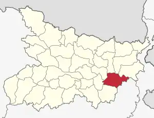 Location of Bhagalpur district in Bihar | |
| Coordinates (Bhagalpur): | |
| Country | India |
| State | Bihar |
| Division | Bhagalpur |
| Headquarters | Bhagalpur |
| Government | |
| • Lok Sabha constituencies | Bhagalpur |
| • Vidhan Sabha constituencies | Bhagalpur, Nathnagar, Pirpainty, Kahalgaon, Sultanganj, Bihpur, Gopalpur |
| Area | |
| • Total | 2,569 km2 (992 sq mi) |
| Population (2011)[1] | |
| • Total | 3,037,766 |
| • Density | 1,200/km2 (3,100/sq mi) |
| • Urban | 602,532 |
| Demographics | |
| • Literacy | 63.14 per cent |
| • Sex ratio | 880/1000 |
| Time zone | UTC+05:30 (IST) |
| Major highways | NH 33,[NH 31],[NH 80] |
| Average annual precipitation | 1166 mm |
| Website | bhagalpur |
Geography
Bhagalpur district occupies an area of 2,569 square kilometres (992 sq mi).[2][3] Bhagalpur district is a part of Bhagalpur Division. The river Ganges flows through the district.
National protected area
Economy
In 2006 the Indian government named Bhagalpur one of the country's 250 Rank 3 backward districts (out of a total of 640).[4] It is one of the 38 districts in Bihar currently receiving funds from the Backward Regions Grant Fund Programme (BRGF).[4]
A 1320MW Thermal Power Plant is going to establish at Pirapinti with a J.V of NHPC, Bihar State Power Generation Company (BSPGCL) and Nalanda Power Company, a subsidiary of RPG Groups.[5]
According to Geological Survey of India, the coal reserve of 1366.75 metric ton has been discovered in Srinagar, Laxmipur, Mandar and Pirpainti block of Bhagalpur district. Bharat Coking Coal Limited is to start mining operations as of September 2019.[6][7]
Demographics
According to the 2011 census Bhagalpur district has a population of 3,037,766.[8] This gives it a ranking of 120th in India (out of a total of 640).[8] The district has a population density of 1,182 inhabitants per square kilometre (3,060/sq mi) .[8] Its population growth rate over the decade 2001–2011 was 25.36%.[8] Bhagalpur has a sex ratio of 880 females for every 1000 males,[8] and a literacy rate of 63.14%.[8]
| Year | Pop. | ±% p.a. |
|---|---|---|
| 1901 | 599,746 | — |
| 1911 | 609,927 | +0.17% |
| 1921 | 569,075 | −0.69% |
| 1931 | 655,803 | +1.43% |
| 1941 | 749,465 | +1.34% |
| 1951 | 841,309 | +1.16% |
| 1961 | 1,022,322 | +1.97% |
| 1971 | 1,250,354 | +2.03% |
| 1981 | 1,582,753 | +2.39% |
| 1991 | 1,909,967 | +1.90% |
| 2001 | 2,423,172 | +2.41% |
| 2011 | 3,037,766 | +2.29% |
| source:[9] | ||
Languages
At the time of the 2011 Census of India, 88.74% of the population in the district spoke Hindi, 10.29% Urdu and 0.45% Santali as their first language.[10]
The primary language used in the district is Angika. Other chief languages include Hindi, Urdu and Bengali language.[11]
Flora and fauna
In 1990 Bhagalpur district became home to the Vikramshila Gangetic Dolphin Sanctuary, which is 50 km (31.1 mi) in length.[12]
Common Service Center in Sultanganj
- S.C.T.I CSC, KrishnaGarh
References
- "DISTRICT CENSUS HANDBOOK - BHAGALPUR" (PDF). censusindia.gov.in. Retrieved 16 January 2021.
- Srivastava, Dayawanti et al. (ed.) (2010). "States and Union Territories: Bihar: Government". India 2010: A Reference Annual (54th ed.). New Delhi, India: Additional Director General, Publications Division, Ministry of Information and Broadcasting (India), Government of India. pp. 1118–1119. ISBN 978-81-230-1617-7.CS1 maint: extra text: authors list (link)
- "Island Directory Tables: Islands by Land Area". United Nations Environment Program. 18 February 1998. Retrieved 11 October 2011.
Obira 2,542km2
- Ministry of Panchayati Raj (8 September 2009). "A Note on the Backward Regions Grant Fund Programme" (PDF). National Institute of Rural Development. Archived from the original (PDF) on 5 April 2012. Retrieved 27 September 2011.
- PTI (26 February 2014). "NHPC inks pact for 1,320-mw thermal plant in Bihar". www.millenniumpost.in. Retrieved 16 January 2020.
- "पटना : नौ जिलों में खनिज के संकेत, भागलपुर में शुरू होगी कोयले की खुदाई". Prabhat Khabar. Retrieved 15 February 2020.
- "BCCL to start mining operations in Bhagalpur district soon, says minister - Times of India". The Times of India. 26 September 2019. Retrieved 15 February 2020.
- "Census India Bhagalpur District" (PDF). Census2011.co.in. 2011. Retrieved 30 September 2011.
- Decadal Variation In Population Since 1901
- 2011 Census of India, Population By Mother Tongue
- M. Paul Lewis, ed. (2009). "Angika: A language of India". Ethnologue: Languages of the World (16th ed.). Dallas, Texas: SIL International. Retrieved 28 September 2011.
- Indian Ministry of Forests and Environment. "Protected areas: Bihar". Archived from the original on 23 August 2011. Retrieved 25 September 2011.
External links
Places adjacent to Bhagalpur district | |
|---|---|
| State symbols | |
|---|---|
| History |
|
| Administration |
|
| Overviews | |
| Divisions and districts | |
| Cities | |
| Municipal Corporation |
|
| Politics | |
| Culture | |