Matatoki
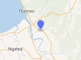
Matatoki is a locality on the Hauraki Plains of New Zealand. It lies on State Highway 26, south east of Thames and north of Paeroa. The Matatoki Stream runs from the Coromandel Range through the area to join the Waihou River.[1][2]
Matatoki | |
|---|---|
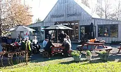 Lunch at the Matatoki Cheese Barn | |
| |
| Coordinates: 37°12′28″S 175°36′24″E | |
| Country | New Zealand |
| Region | Waikato |
| District | Thames-Coromandel District |
| Population (2018) | |
| • Total | 1,059 |
The Kopu sawmill, a few km north of Matatoki, closed at the end of June, 2008, with the loss of 145 jobs.[3]
History
The eastern bank of the Waihou River near Matatoki was the location for many Hauraki Māori pā, such as Oruarangi pā and Paterangi pā, which were likely first settled in the 1300s.[4] Between the 1930s and 1960s, Oruarangi pā was an important archaeological site for Classic period Māori artifacts.[4]
Demographics
| Year | Pop. | ±% p.a. |
|---|---|---|
| 2006 | 1,062 | — |
| 2013 | 1,002 | −0.83% |
| 2018 | 1,059 | +1.11% |
| Source: [5] | ||
The statistical area of Matatoki-Puriri, which at 161 square kilometres is much larger than this locality, had a population of 1,059 at the 2018 New Zealand census, an increase of 57 people (5.7%) since the 2013 census, and a decrease of 3 people (-0.3%) since the 2006 census. There were 396 households. There were 540 males and 519 females, giving a sex ratio of 1.04 males per female. The median age was 45.5 years, with 204 people (19.3%) aged under 15 years, 165 (15.6%) aged 15 to 29, 507 (47.9%) aged 30 to 64, and 180 (17.0%) aged 65 or older.
Ethnicities were 93.2% European/Pākehā, 17.0% Māori, 1.4% Pacific peoples, 0.6% Asian, and 0.8% other ethnicities (totals add to more than 100% since people could identify with multiple ethnicities).
The proportion of people born overseas was 8.5%, compared with 27.1% nationally.
Although some people objected to giving their religion, 59.5% had no religion, 28.0% were Christian, 0.3% were Hindu, and 1.4% had other religions.
Of those at least 15 years old, 90 (10.5%) people had a bachelor or higher degree, and 234 (27.4%) people had no formal qualifications. The median income was $32,800. The employment status of those at least 15 was that 477 (55.8%) people were employed full-time, 153 (17.9%) were part-time, and 15 (1.8%) were unemployed.[5]
Education
Matatoki School is a coeducational full primary school (years 1-8) with a roll of 69 as of March 2020.[6][7] The school opened in 1920.[8]
References
- Peter Dowling (editor) (2004). Reed New Zealand Atlas. Reed Books. pp. map 15. ISBN 0-7900-0952-8.CS1 maint: extra text: authors list (link)
- Roger Smith, GeographX (2005). The Geographic Atlas of New Zealand. Robbie Burton. pp. map 44. ISBN 1-877333-20-4.
- "Kopu mill to close, 145 jobs to be lost". The New Zealand Herald. 6 May 2008.
- Prickett, Nigel (1990). "ARCHAEOLOGICAL EXCAVATIONS AT RAUPA: THE 1987 SEASON". Records of the Auckland Institute and Museum. 27: 73–153. ISSN 0067-0464.
- "Statistical area 1 dataset for 2018 Census". Statistics New Zealand. March 2020. Matatoki-Puriri (168300). 2018 Census place summary: Matatoki-Puriri
- "New Zealand Schools Directory". New Zealand Ministry of Education. Retrieved 26 April 2020.
- Education Counts: Matatoki School
- "Matatoki School Centenary 1920 to 2020!". Matatoki School. 10 March 2020. Archived from the original on 3 October 2020.
