Te Puru
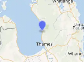
Te Puru is a locality on the western side of the Coromandel Peninsula of New Zealand. State Highway 25 runs through it. Tapu lies about 7 km to the north, and Thames is about 12 km to the south.[1][2] The Te Puru Stream and about 18 tributaries drain a steep hilly 23 km² area of the Coromandel Range, almost entirely covered by native forest. It runs through the settlement and into the Firth of Thames to the west. Flooding has been a problem.[3]
Te Puru | |
|---|---|
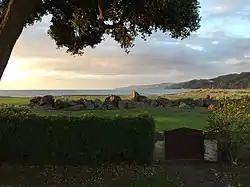 View from a bach at Te Puru | |
| |
| Coordinates: 37°2′48″S 175°31′18″E | |
| Country | New Zealand |
| Region | Waikato |
| District | Thames-Coromandel District |
| Population (2013) | |
| • Total | 846 |
Demographics
| Year | Pop. | ±% p.a. |
|---|---|---|
| 2006 | 1,710 | — |
| 2013 | 1,533 | −1.55% |
| 2018 | 1,704 | +2.14% |
| Source: [4] | ||
The statistical area of Thames Coast, which at 116 square kilometres is much larger than the locality, covers the west coast of the Coromandel between Waikawau River and Tararu Creek. It had a population of 1,704 at the 2018 New Zealand census, an increase of 171 people (11.2%) since the 2013 census, and a decrease of 6 people (-0.4%) since the 2006 census. There were 717 households. There were 846 males and 858 females, giving a sex ratio of 0.99 males per female. The median age was 58.1 years, with 198 people (11.6%) aged under 15 years, 162 (9.5%) aged 15 to 29, 735 (43.1%) aged 30 to 64, and 606 (35.6%) aged 65 or older.
Ethnicities were 89.6% European/Pākehā, 19.0% Māori, 1.8% Pacific peoples, 1.8% Asian, and 2.1% other ethnicities (totals add to more than 100% since people could identify with multiple ethnicities).
The proportion of people born overseas was 14.4%, compared with 27.1% nationally.
Although some people objected to giving their religion, 53.0% had no religion, 34.0% were Christian, 0.2% were Hindu, 0.2% were Muslim, 0.7% were Buddhist and 3.0% had other religions.
Of those at least 15 years old, 234 (15.5%) people had a bachelor or higher degree, and 372 (24.7%) people had no formal qualifications. The median income was $22,900. The employment status of those at least 15 was that 471 (31.3%) people were employed full-time, 258 (17.1%) were part-time, and 60 (4.0%) were unemployed.[4]
Education
Te Puru School is a coeducational full primary (years 1-8) school with a roll of 162 students as of March 2020.[5][6]
History
Te Puru suffered severe flooding in 2002, when a low-pressure system led to extensive flooding on the Coromandel Peninsula and the south-west Waikato region.[7] Te Puru and Waiomu were included in the ‘high impact’ area of the storm.[8] Private and public property was damaged during the flood.
References
- Peter Dowling (editor) (2004). Reed New Zealand Atlas. Reed Books. pp. map 16. ISBN 0-7900-0952-8.CS1 maint: extra text: authors list (link)
- Roger Smith, GeographX (2005). The Geographic Atlas of New Zealand. Robbie Burton. pp. map 40. ISBN 1-877333-20-4.
- "Proposals for Te Puru" (PDF). Environment Waikato.
- "Statistical area 1 dataset for 2018 Census". Statistics New Zealand. March 2020. Thames Coast (167200). 2018 Census place summary: Thames Coast
- "New Zealand Schools Directory". New Zealand Ministry of Education. Retrieved 26 April 2020.
- Education Counts: Te Puru School
- NIWA - June 2002 Upper North Island Weather Bomb.
- Ministry for the Environment - The Waikato Weather Bomb: Understanding the impact.
