Melville Island (Australia)
Melville Island (Tiwi: Yermalner) is an island in the eastern Timor Sea, off the coast of the Northern Territory, Australia. Along with Bathurst Island and nine smaller uninhabited islands, it forms part of the group known as the Tiwi Islands, which are under the jurisdiction of the Northern Territory in association with the Tiwi Land Council as the regional authority.
| Native name: (Tiwi) Yermalner | |
|---|---|
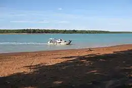 Melville Island, viewed from Bathurst Island | |
Melville Island is an island in the eastern Timor Sea, off the coast of the Northern Territory, Australia. | |
| Geography | |
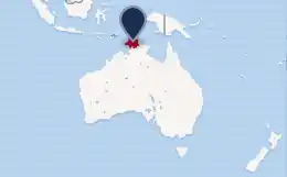
| Location | Timor Sea |
| Coordinates | 11°33′S 130°56′E |
| Archipelago | Tiwi Islands |
| Major islands | Melville, Irrititu |
| Area | 5,786 km2 (2,234 sq mi) |
| Administration | |
Australia | |
| Territory | Northern Territory |
| Largest settlement | Milikapiti (pop. 559) |
| Demographics | |
| Population | ca. 1030 |
| Ethnic groups | Tiwi |
History
Indigenous people have occupied the area that became the Tiwi Islands for at least 40,000 years.[1] It is said that the first European to sight the island was Abel Tasman in 1644. Explorer Phillip Parker King (son of governor of New South Wales Philip Gidley King) named it for Robert Dundas, 2nd Viscount Melville, first Lord of the Admiralty, who is also commemorated by the much larger Melville Island in the Canadian Arctic Archipelago. Shortly after this, the British made the first attempt to settle Australia's north coast, at the short-lived Fort Dundas on Melville Island. The settlement lasted from 1824 to 1828.
During World War II the small Snake Bay Patrol manned by local Tiwi people was established as part of the military forces deployed to protect the island against any Japanese landings.
Geography and climate
The island lies in the eastern Timor Sea, approximately 60 kilometres (37 mi) north of the Darwin and west of the Cobourg Peninsula in Arnhem Land, in the Northern Territory. At 5,786 square kilometres (2,234 sq mi), it is just outside the 100 largest islands in the world, but is the second biggest island in Australia after Tasmania. Only 55 metres (180 ft) south of its southern tip is Irrititu Island, with an area of 1.60 square kilometres (0.62 sq mi).[2] The islands have a tropical climate.
Population
The largest settlement on the island is Milikapiti, with a population of 559. The second largest is Pirlangimpi (Pularumpi, formerly Garden Point), with a population of 440, located 27 km (17 mi) west of Milikapiti, on the west coast of Melville Island. About 30 more people live in five family outstations.
Governance
As part of the Tiwi Islands, Melville is under the jurisdiction of the Northern Territory, with the Tiwi Land Council as the regional authority.
References
- "Timeline: Dreamtime to 1978". Tiwi Land Council. Retrieved 7 January 2020.
- John Woinarski; Brooke Rankmore; Alaric Fisher; Kym Brennan; Damian Milne (December 1997). "The natural occurrence of northern quolls Dasyurus hallucatus on islands of the Northern Territory: assessment of refuges from the threat posed by cane toads Bufo marinus" (PDF). Australian Government and Northern Territory Government. p. 16. Archived from the original (PDF) on 10 April 2011. Retrieved 30 May 2011.
Further reading
- Northern Territory Library. "A History of Melville Island, Tiwi Islands" (PDF). NT Stories. Northern Territory Government. Dept of Natural Resources, Environment, The Arts and Sport. Cite journal requires
|journal=(help) - "Garden Point Mission (1941 - 1969)". Find and Connect. - This was an institution where girls were taken from their families on the mainland, in one example of the Stolen Generations.
- Hart, C. W. (July 1930). "The Tiwi of Melville and Bathurst Islands". Oceania. 1 (2): 167–180. doi:10.1002/j.1834-4461.1930.tb01643.x. JSTOR 40327319.
External links
| Wikimedia Commons has media related to Melville Island, Australia. |
Islands of the Northern Territory | |
|---|---|
|