Merritt, South Dakota
Merritt is a ghost town in Lawrence County and Pennington County, South Dakota, United States of America.[1]
Merritt, South Dakota | |
|---|---|
Town | |
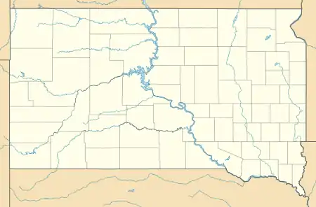 Merritt Location of Merritt in South Dakota. | |
| Coordinates: 44°08′27″N 103°34′07″W[1] | |
| Country | United States |
| State | South Dakota |
| Counties | Lawrence and Pennington |
| Elevation | 5,105 ft (1,556 m) |
| Time zone | UTC-7 (MST) |
| • Summer (DST) | UTC-6 (MDT) |
History
Merritt was a small logging community that once included a school, post office, and a ranger station. It provided fuel and wood for the mines near Lead and Deadwood. It has since been abandoned. In the 1970s, all that remained of the town was a trout ranch.[2]
Geography
The old site is located on the county line between Pennington and Lawrence Counties in the US state of South Dakota, on the west side of US 385. Merritt is inside of the Black Hills. It was located at the southern end of the Black Hills & Fort Pierre Railroad. It was 18 miles north of Hill City.[2] Its elevation is 5,105 feet (1,556 m).[1]
References
- "Merritt". Geographic Names Information System. United States Geological Survey. 13 February 1980. Retrieved 11 September 2013.
- Parker, Watson, and Hugh K. Lambert. Black Hills Ghost Towns. First ed. Vol. 1. Chicago, IL: The Swallow Press Incorporated, 1974. 134. 1 vols. Print.
Municipalities and communities of Lawrence County, South Dakota, United States | ||
|---|---|---|
| Cities | 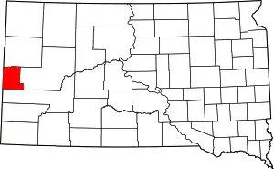 | |
| Township | ||
| CDPs | ||
| Other unincorporated communities | ||
| Ghost towns | ||
| ||
Municipalities and communities of Pennington County, South Dakota, United States | ||
|---|---|---|
| Cities | 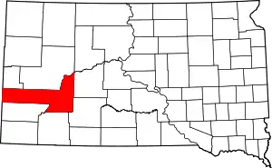 | |
| Towns | ||
| CDPs | ||
| Former CDP | ||
| Unincorporated communities | ||
| Ghost towns | ||
| Footnotes | ‡This populated place also has portions in an adjacent county or counties | |
| ||
This article is issued from Wikipedia. The text is licensed under Creative Commons - Attribution - Sharealike. Additional terms may apply for the media files.