Minnesota State Highway 1
Minnesota State Highway 1 (MN 1) is a state highway across northern Minnesota, United States, which runs from North Dakota Highway 54 (ND 54) at the North Dakota state line (at the Red River in Oslo) and continues east to its eastern terminus at MN 61 at the unincorporated community of Illgen City in Beaver Bay Township on the North Shore of Lake Superior. At 346 miles (557 km) in length, Highway 1 is the longest state route in Minnesota.[2]
| ||||
|---|---|---|---|---|
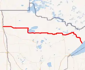
MN 1 highlighted in red | ||||
| Route information | ||||
| Maintained by MnDOT | ||||
| Length | 345.954 mi[1] (556.759 km) | |||
| Existed | 1933[2]–present | |||
| Major junctions | ||||
| West end | ||||
| East end | ||||
| Location | ||||
| Counties | Marshall, Pennington, Clearwater, Beltrami, Koochiching, Itasca, St. Louis, Lake | |||
| Highway system | ||||
| ||||

Route description
MN 1 serves as an east–west route between Oslo, Warren, Thief River Falls, Red Lake, Northome, Cook, Tower, Ely, and Beaver Bay Township.
The roadway passes through the following forests:
- Finland State Forest in Lake County
- Superior National Forest in Lake and Saint Louis counties
- Bear Island State Forest in Lake and Saint Louis counties
- Kabetogama State Forest in Saint Louis County
- George Washington State Forest in Itasca County
- Koochiching State Forest in Koochiching County
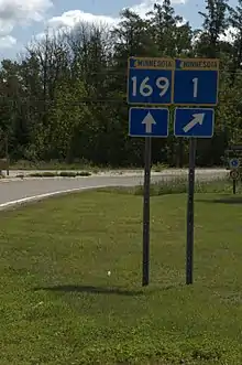
The route runs concurrently with MN 169 for 26 miles (42 km) from Vermilion Lake Township (west of Tower) to Ely.
MN 1 also runs concurrently with MN 89 for 28 miles (45 km) on the southwest side of Red Lake. This is the longest concurrency with another state highway within Minnesota.
History
Most of MN 1 was authorized in 1933,[3] except for a section between U.S. Highway 75 (US 75) and MN 32 at Thief River Falls, which was part of Minnesota Constitutional Route 33 authorized in 1920.[2]
The route was given the MN 1 designation because it was one of the longest trunk highways, and would allow re-use of the MN 1 markers removed from along US 61 and US 65 in 1934.[2]
When it was marked in 1934, it was only paved from US 75 to MN 32 and from MN 169 to Ely.[4]
As recently as 1963, significant portions of MN 1 were unpaved.
MN 1 still had an unpaved segment in 1996, between US 53 and MN 169 in northern Saint Louis County. At that point it was swapped with paved County Road 22.[2]
Major intersections
| County | Location | mi[1][5] | km | Destinations | Notes | |||
|---|---|---|---|---|---|---|---|---|
| Red River of the North | 0.000 | 0.000 | Continuation in North Dakota | |||||
| Marshall | Oak Park Township | 1.554 | 2.501 | Western end of MN 220 concurrency | ||||
| Alvarado | 6.555 | 10.549 | Eastern end of MN 220 concurrency | |||||
| Warren | 17.050 | 27.439 | ||||||
| Pennington | Thief River Falls | 44.457 | 71.547 | Western end of US 59 concurrency | ||||
| 45.771 | 73.661 | Southern end of MN 32 concurrency; eastern end of US 59 concurrency | ||||||
| 46.118 | 74.220 | Northern end of MN 32 concurrency | ||||||
| Goodridge Township | 63.367 | 101.979 | Southern terminus of MN 219 | |||||
| Beltrami | Red Lake Indian Reservation | 89.331 | 143.764 | Northern end of MN 89 concurrency | ||||
| Clearwater |
No major junctions | |||||||
| Beltrami | Red Lake Indian Reservation | 116.960 | 188.229 | Southern end of MN 89 concurrency | ||||
| Cormant Township | 141.331 | 227.450 | Western end of MN 72 concurrency | |||||
| Shooks | 146.400 | 235.608 | Eastern end of MN 72 concurrency | |||||
| Koochiching | Unorganized Territory of Northome | 151.288 | 243.474 | Southern end of US 71 concurrency | ||||
| Northome | 154.276 | 248.283 | Northern end of US 71 concurrency | |||||
| 154.564 | 248.747 | |||||||
| Unorganized Territory of Northome | 178.128 | 286.669 | Northern end of MN 6 concurrency | |||||
| Itasca | Unorganized Territory of Effie | 180.452 | 290.409 | Southern end of MN 6 concurrency | ||||
| Effie | 186.656 | 300.394 | ||||||
| Carpenter Township | 211.369 | 340.165 | Western end of MN 65 concurrency | |||||
| 215.424 | 346.691 | Eastern end of MN 65 concurrency | ||||||
| St. Louis | Linden Grove | 229.223 | 368.899 | |||||
| Field Township | 236.245 | 380.199 | Northern end of US 53 concurrency | |||||
| Sherman Corner | 244.377 | 393.287 | Southern end of US 53 concurrency | |||||
| Peyla | 258.848 | 416.575 | Western end of MN 169 concurrency | |||||
| Tower | 263.159 | 423.513 | ||||||
| Ely | 286.208 | 460.607 | Eastern end of MN 169 concurrency | |||||
| Lake | Illgen City | 347.340 | 558.990 | |||||
1.000 mi = 1.609 km; 1.000 km = 0.621 mi
| ||||||||
See also
References
- "Trunk Highway Log Point Listing - Construction District 1" (PDF). Minnesota Department of Transportation. September 4, 2009. Archived from the original (PDF) on December 4, 2008. Retrieved August 21, 2010.
- Steve Riner (July 26, 2003). Details of Routes 1-25. Unofficial Minnesota Highways Page. Accessed August 27, 2004.
- "Chapter 440-H.F. No. 2000". Session Laws of Minnesota for 1933. Mike Holm, Secretary of State. pp. 881–897.
- Minnesota Highway Department; McGill-Warner (1934). Map of Trunk Highway System, State of Minnesota (Map). 1:760,320. St. Paul: Minnesota Highway Department. OCLC 5673160, 80405240. Retrieved November 16, 2010 – via Minnesota Digital Library. (Showing road conditions as of May 1, 1934)
- "Trunk Highway Log Point Listing - Construction District 2" (PDF). Minnesota Department of Transportation. September 4, 2009. Archived from the original (PDF) on December 4, 2008. Retrieved August 21, 2010.
External links
| Wikimedia Commons has media related to Minnesota State Highway 1. |
- Minnesota Highway 1, MN Highway Endings.