Minnesota State Highway 6
Minnesota State Highway 6 (MN 6) is a 147.775-mile-long (237.821 km) highway in east-central and north-central Minnesota, which runs from its intersection with State Highway 18 in Bay Lake Township near Garrison and continues north to its northern terminus at its intersection with U.S. Highway 71 and County Road 30 in Big Falls.
| ||||
|---|---|---|---|---|
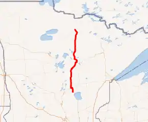
MN 6 highlighted in red | ||||
| Route information | ||||
| Maintained by MnDOT | ||||
| Length | 147.775 mi[1] (237.821 km) | |||
| Existed | 1920, 1933–present | |||
| Major junctions | ||||
| South end | ||||
| North end | ||||
| Location | ||||
| Counties | Crow Wing, Cass, Itasca, Koochiching | |||
| Highway system | ||||
| ||||

Route description
State Highway 6 serves as a north–south route between Bay Lake Township, Deerwood, Crosby, Remer, Deer River, and Big Falls in east-central and north-central Minnesota.
The route passes through the Chippewa National Forest in Cass and Itasca counties.
Highway 6 passes through the following state forests:
- Crow Wing State Forest (briefly) in Crow Wing County
- Land O'Lakes State Forest in Cass County
- Remer State Forest in Cass County
- Big Fork State Forest in Itasca County
- Koochiching State Forest in Koochiching County
Schoolcraft State Park is located on Highway 6 in Cass County on the banks of the Mississippi River. The park is located south of Deer River and west of Grand Rapids.
Highway 6 parallels U.S. Highway 169 for part of its route in northern Minnesota.
The route also parallels scenic State Highway 38 for part of its route.
History
State Highway 6 was authorized in 1920 and 1933.[2]
The route was completely paved by 1970.[2]
Major intersections
| County | Location | mi[1] | km | Destinations | Notes |
|---|---|---|---|---|---|
| Crow Wing | Bay Lake Township | 0.000 | 0.000 | ||
| Deerwood | 9.432 | 15.179 | Eastern end of MN 210 overlap | ||
| Crosby | 13.828 | 22.254 | Western end of MN 210 overlap | ||
| Wolford Township | 18.381– 18.427 | 29.581– 29.655 | Bridge over the Mississippi River | ||
| Cass | Remer Township | 55.573 | 89.436 | Western end of MN 200 overlap | |
| Remer | 56.344 | 90.677 | Eastern end of MN 200 overlap | ||
| Itasca | Deer Lake | 70.840– 70.882 | 114.006– 114.074 | Bridge over the Mississippi River | |
| 77.522 | 124.760 | Eastern end of US 2 overlap | |||
| Deer River | 83.064 | 133.679 | Western end of US 2 overlap | ||
| Talmoon | 109.205 | 175.748 | |||
| Unorganized Territory of Effie | 120.202 | 193.446 | South end of MN 1 overlap | ||
| Koochiching | Unorganized Territory of Northome | 122.584 | 197.280 | North end of MN 1 overlap | |
| Big Falls | 147.775 | 237.821 | |||
1.000 mi = 1.609 km; 1.000 km = 0.621 mi
| |||||
References
- Minnesota Department of Transportation. "Statewide Trunk Logpoint Listing" (PDF). St. Paul: Minnesota Department of Transportation. Retrieved November 10, 2015.
- Riner, Steve. "Details of routes 1–25". The Unofficial Minnesota Highways Page. Self-published. Retrieved September 20, 2010.