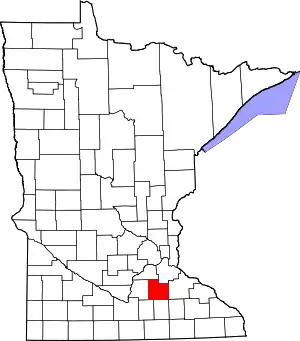
Rice County, Minnesota
Rice County is a county located in the south central portion of the U.S. state of Minnesota. As of the 2010 census, the population was 64,142.[1] Its county seat is Faribault.[2]
Rice County | |
|---|---|
 | |
 Location within the U.S. state of Minnesota | |
 Minnesota's location within the U.S. | |
| Coordinates: 44°22′N 93°18′W | |
| Country | |
| State | |
| Founded | March 5, 1853 |
| Named for | Henry Mower Rice |
| Seat | Faribault |
| Largest city | Faribault |
| Area | |
| • Total | 516 sq mi (1,340 km2) |
| • Land | 496 sq mi (1,280 km2) |
| • Water | 20 sq mi (50 km2) 3.9%% |
| Population (2010) | |
| • Total | 64,142 |
| • Estimate (2019) | 66,972 |
| • Density | 133/sq mi (51/km2) |
| Time zone | UTC−6 (Central) |
| • Summer (DST) | UTC−5 (CDT) |
| Congressional districts | 1st, 2nd |
| Website | www |

Rice County comprises the Faribault-Northfield, MN Micropolitan Statistical Area, which is included in the Minneapolis-St. Paul, MN-WI Combined Statistical Area.
History
Rice County was founded on March 5, 1853.[3] It was named for Henry Mower Rice, a fur trader who became instrumental in creation of the Minnesota Territory and its subsequent growth and development.[4]
Geography
The Cannon River flows northeasterly through the center of the county, on its way to discharge into the Mississippi River at Red Wing. The Straight River flows northerly into the county from Steele County to its discharge point into the Cannon River at Faribault. The North Fork of the Zumbro River rises in south-central Rice County, and flows eastward into Goodhue County on its way to discharge into the Mississippi east of Kellogg.
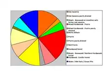
The county terrain consists of low, rolling hills, entirely devoted to agriculture, and dotted with lakes.[5] The county slopes to the east and north; its highest point is near its SE corner, at 1,263' (385m) ASL.[6] The county has an area of 516 square miles (1,340 km2), of which 496 square miles (1,280 km2) is land and 20 square miles (52 km2) (3.9%) is water.[7] The Cannon River flows northeastwardly through the county, collecting the Straight River in Faribault. The North Fork of the Zumbro River has its headwaters in the county's southeastern part.[8] Rice is one of 17 Minnesota savanna counties with more savanna soils than either prairie or forest soils.
Major highways
 Interstate 35
 I-35 BL
 Minnesota State Highway 3
 Minnesota State Highway 13
 Minnesota State Highway 19
 Minnesota State Highway 21
 Minnesota State Highway 60
 Minnesota State Highway 99
 Minnesota State Highway 246
 Minnesota State Highway 298
 Minnesota State Highway 299
Adjacent counties
- Dakota County - northeast
- Goodhue County - east
- Dodge County - southeast
- Steele County - south
- Waseca County - southwest
- Le Sueur County - west
- Scott County - northwest
Protected areas[5]
- Cannon Lake Wilderness Area
- Cannon River Trout Lily Scientific and Natural Area
- Faribault State Wildlife Management Area
- Nerstrand Big Woods State Park
- River Bend Nature Area
- Sakatah Lake State Park (part)
- Shager Park
- Townsend Woods Scientific and Natural Area
- Whitney Island Scientific and Natural Area
Lakes[5]
- Cannon Lake
- Caron Lake
- Cedar Lake
- Circle Lake
- Crystal Lake
- Duban Lake
- Dudley Lake
- Fox Lake
- French Lake
- Hatch Lake
- Horseshoe Lake (part)
- Hunt Lake
- Kelly Lake
- Mazaska Lake
- Metogga Lake
- Mud Lake
- Phelps Lake
- Rice Lake
- Roberds Lake
- Sakatah Lake (part)
- Shields Lake
- Sprague Lake
- Union Lake
- Weinberger Lake
- Wells Lake
- Willing Lake
Demographics
| Historical population | |||
|---|---|---|---|
| Census | Pop. | %± | |
| 1860 | 7,543 | — | |
| 1870 | 16,083 | 113.2% | |
| 1880 | 22,481 | 39.8% | |
| 1890 | 23,968 | 6.6% | |
| 1900 | 26,080 | 8.8% | |
| 1910 | 25,911 | −0.6% | |
| 1920 | 28,307 | 9.2% | |
| 1930 | 29,974 | 5.9% | |
| 1940 | 32,160 | 7.3% | |
| 1950 | 36,235 | 12.7% | |
| 1960 | 38,988 | 7.6% | |
| 1970 | 41,582 | 6.7% | |
| 1980 | 46,087 | 10.8% | |
| 1990 | 49,183 | 6.7% | |
| 2000 | 56,665 | 15.2% | |
| 2010 | 64,142 | 13.2% | |
| 2019 (est.) | 66,972 | [10] | 4.4% |
| US Decennial Census[11] 1790-1960[12] 1900-1990[13] 1990-2000[14] 2010-2019[1] | |||

2000 census
As of the 2000 United States Census, there were 56,665 people, 18,888 households, and 13,353 families in the county. The population density was 114/sqmi (44.1/km2). There were 20,061 housing units at an average density of 40.4/sqmi (15.6/km2). The racial makeup of the county was 93.59% White, 1.31% Black or African American, 0.43% Native American, 1.46% Asian, 0.04% Pacific Islander, 1.87% from other races, and 1.30% from two or more races. 5.50% of the population were Hispanic or Latino of any race. 32.1% were of German, 14.7% Norwegian, 7.2% Irish and 5.3% Czech ancestry.
There were 18,888 households, out of which 36.50% had children under the age of 18 living with them, 58.10% were married couples living together, 8.60% had a female householder with no husband present, and 29.30% were non-families. 23.90% of all households were made up of individuals, and 9.10% had someone living alone who was 65 years of age or older. The average household size was 2.65 and the average family size was 3.14.
The county population contained 25.30% under the age of 18, 15.80% from 18 to 24, 27.40% from 25 to 44, 20.20% from 45 to 64, and 11.40% who were 65 years of age or older. The median age was 33 years. For every 100 females there were 101.80 males. For every 100 females age 18 and over, there were 100.30 males.
The median income for a household in the county was $48,651, and the median income for a family was $56,407. Males had a median income of $36,771 versus $26,151 for females. The per capita income for the county was $19,695. About 4.00% of families and 6.90% of the population were below the poverty line, including 5.70% of those under age 18 and 10.70% of those age 65 or over.
Parks and recreation
- Ackman Park 3 miles (4.8 km) west of Faribault
- Albers Park in Webster
- Caron Park in Cannon City
- Falls Creek Park 1-mile (1.6 km) east of Faribault
- Heron Island in Shieldsville
- Hirdler Park 10 miles (16 km) west of Faribault
- Kalina Park in Wheatland
- King Mill Park in Faribault
Communities
Cities
- Dennison (partly in Goodhue County)
- Dundas
- Faribault (county seat)
- Lonsdale
- Morristown
- Nerstrand
- Northfield (partly in Dakota County)
Census-designated place
Unincorporated communities
Politics
From its first participating election in 1860 through 1960, Rice County was traditionally Republican, voting for the Republican nominee in every election save 1912 (when it voted for Bull Moose nominee and former Republican president Theodore Roosevelt) and Franklin Roosevelt's 1932 and 1936 landslides.[15] From 1964 through 2012, it became a Democratic stronghold, voting for the Democratic nominee in every election save Richard Nixon's 1972 landslide. In 2016, it voted for a Republican for the first time since 1972 (and for a Republican who was not winning a majority of the national popular vote for the first time since 1960), although it gave him only a plurality, with 7.9% voting third party. However, in 2020, with the third party vote sinking to 2.3%, it voted Republican again, making it the first time since 1956 and 1960 that the county has voted Republican two elections in a row (although the Republican margin was only 62 votes out of over 35,000 cast).
| Year | Republican | Democratic | Third parties |
|---|---|---|---|
| 2020 | 48.9% 17,464 | 48.8% 17,402 | 2.3% 820 |
| 2016 | 47.6% 15,429 | 44.5% 14,437 | 7.9% 2,577 |
| 2012 | 44.6% 14,384 | 52.9% 17,054 | 2.6% 829 |
| 2008 | 43.2% 13,723 | 54.7% 17,381 | 2.2% 695 |
| 2004 | 45.2% 13,881 | 53.4% 16,425 | 1.4% 439 |
| 2000 | 41.8% 10,876 | 50.5% 13,140 | 7.7% 2,005 |
| 1996 | 30.1% 7,016 | 55.0% 12,821 | 14.9% 3,483 |
| 1992 | 29.1% 7,015 | 45.2% 10,908 | 25.7% 6,190 |
| 1988 | 44.5% 9,460 | 54.4% 11,570 | 1.1% 237 |
| 1984 | 48.6% 10,456 | 50.6% 10,880 | 0.9% 189 |
| 1980 | 39.5% 8,168 | 46.1% 9,531 | 14.4% 2,974 |
| 1976 | 42.4% 8,311 | 54.0% 10,590 | 3.6% 706 |
| 1972 | 52.6% 9,195 | 46.2% 8,065 | 1.2% 215 |
| 1968 | 45.9% 7,037 | 50.8% 7,785 | 3.2% 497 |
| 1964 | 37.2% 5,518 | 62.7% 9,299 | 0.2% 26 |
| 1960 | 54.9% 8,248 | 44.9% 6,752 | 0.2% 31 |
| 1956 | 65.2% 8,471 | 34.6% 4,489 | 0.2% 24 |
| 1952 | 68.2% 9,334 | 31.6% 4,330 | 0.2% 29 |
| 1948 | 51.1% 6,301 | 47.3% 5,832 | 1.5% 188 |
| 1944 | 60.3% 6,824 | 39.5% 4,470 | 0.3% 28 |
| 1940 | 63.3% 8,143 | 36.4% 4,687 | 0.4% 45 |
| 1936 | 39.7% 4,888 | 48.1% 5,928 | 12.3% 1,511 |
| 1932 | 42.3% 4,743 | 56.1% 6,289 | 1.6% 183 |
| 1928 | 56.5% 6,576 | 43.1% 5,014 | 0.4% 49 |
| 1924 | 61.3% 5,883 | 12.5% 1,199 | 26.3% 2,521 |
| 1920 | 74.6% 6,500 | 23.4% 2,040 | 2.0% 175 |
| 1916 | 51.7% 2,408 | 44.7% 2,083 | 3.7% 170 |
| 1912 | 22.2% 1,020 | 35.1% 1,613 | 42.7% 1,964 |
| 1908 | 61.5% 2,821 | 35.2% 1,614 | 3.4% 155 |
| 1904 | 71.4% 3,160 | 24.0% 1,063 | 4.6% 205 |
| 1900 | 60.4% 2,924 | 34.9% 1,688 | 4.8% 232 |
| 1896 | 61.0% 3,483 | 35.1% 2,002 | 4.0% 226 |
| 1892 | 48.3% 2,245 | 38.6% 1,794 | 13.1% 610 |
| Position | Name | District | Next Election | |
|---|---|---|---|---|
| Commissioner | Jake Gillen | District 1 | 2020 | |
| Commissioner | Galen Malecha | District 2 | 2020 | |
| Commissioner | Dave Miller | District 3 | 2022 | |
| Commissioner | Steve Underdahl | District 4 | 2022 | |
| Commissioner | Jeff Docken | District 5 | 2020 | |
| Position | Name | Affiliation | District | |
|---|---|---|---|---|
| Senate | Rich Draheim[18] | Republican | District 20 | |
| Senate | John Jasinski[19] | Republican | District 24 | |
| House of Representatives | Todd Lippert[20] | Democrat | District 20B | |
| House of Representatives | Brian Daniels[21] | Republican | District 24B | |
| Position | Name | Affiliation | District | |
|---|---|---|---|---|
| House of Representatives | Jim Hagedorn[22] | Republican | 1st | |
| House of Representatives | Angie Craig[23] | Democrat | 2nd | |
| Senate | Amy Klobuchar[24] | Democrat | N/A | |
| Senate | Tina Smith[25] | Democrat | N/A | |
References
- "State & County QuickFacts". United States Census Bureau. Retrieved September 1, 2013.
- "Find a County". National Association of Counties. Archived from the original on May 31, 2011. Retrieved June 7, 2011.
- "Minnesota Place Names". Minnesota Historical Society. Archived from the original on June 20, 2012. Retrieved March 19, 2014.
- Fedo, Michael (2002). Pocket Guide to Minnesota Place Names. Canada: Minnesota Historical Society Press. p. 127. ISBN 0-87351-424-6. Archived from the original on May 27, 2009.
- Rice County MN Google Maps (accessed 3 April 2019)
- "Find an Altitude/Rice County MN" Google Maps (accessed April 3, 2019)
- "2010 Census Gazetteer Files". US Census Bureau. August 22, 2012. Archived from the original on September 21, 2013. Retrieved October 24, 2014.
- Minnesota Atlas & Gazetteer. Yarmouth ME: DeLorme. 1994. p. 33. ISBN 0-89933-222-6.
- Nelson, Steven (2011). Savanna Soils of Minnesota. Minnesota: Self. pp. 43-48. ISBN 978-0-615-50320-2.
- "Population and Housing Unit Estimates". Retrieved March 26, 2020.
- "US Decennial Census". US Census Bureau. Archived from the original on April 26, 2015. Retrieved October 24, 2014.
- "Historical Census Browser". University of Virginia Library. Retrieved October 24, 2014.
- "Population of Counties by Decennial Census: 1900 to 1990". US Census Bureau. Retrieved October 24, 2014.
- "Census 2000 PHC-T-4. Ranking Tables for Counties: 1990 and 2000" (PDF). US Census Bureau. Retrieved October 24, 2014.
- "County winners, 1836-2016". Google Docs. Retrieved January 10, 2021.
- Leip, David. "Atlas of US Presidential Elections". uselectionatlas.org. Retrieved October 10, 2018.
- "Board of Commissioners | Rice County, MN". www.co.rice.mn.us. Retrieved June 26, 2020.
- "MN State Senate". www.senate.mn. Retrieved June 26, 2020.
- "MN State Senate". www.senate.mn. Retrieved June 26, 2020.
- "Rep. Todd Lippert (20B) - Minnesota House of Representatives". www.house.leg.state.mn.us. Retrieved June 26, 2020.
- "Rep. Brian Daniels (24B) - Minnesota House of Representatives". www.house.leg.state.mn.us. Retrieved June 26, 2020.
- "Representative Jim Hagedorn". Representative Jim Hagedorn. Retrieved June 26, 2020.
- "Representative Angie Craig". Representative Angie Craig. Retrieved June 26, 2020.
- "U.S. Senator Amy Klobuchar". www.klobuchar.senate.gov. Retrieved June 24, 2020.
- "Home". Senator Tina Smith. Retrieved June 24, 2020.
External links
Places adjacent to Rice County, Minnesota | ||||||||||
|---|---|---|---|---|---|---|---|---|---|---|
| ||||||||||
Municipalities and communities of Rice County, Minnesota, United States | ||
|---|---|---|
| Cities | Map of Minnesota highlighting Rice County | |
| Townships | ||
| CDP | ||
| Unincorporated communities | ||
| Ghost towns/Neighborhoods | ||
| Footnotes | ‡This populated place also has portions in an adjacent county or counties | |
| ||

| Authority control |
|---|