Nicollet County, Minnesota
Nicollet County is a county in the U.S. state of Minnesota. As of the 2010 census, the population was 32,727.[1] Its county seat is St. Peter.[2]
Nicollet County | |
|---|---|
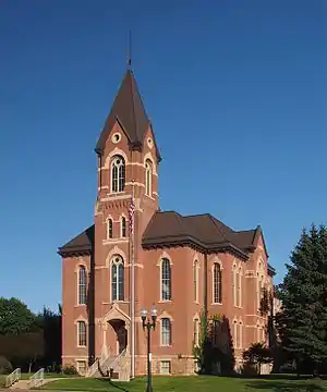 Nicollet County Courthouse | |
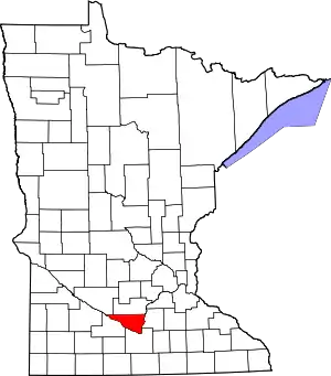 Location within the U.S. state of Minnesota | |
 Minnesota's location within the U.S. | |
| Coordinates: 44°20′N 94°15′W | |
| Country | |
| State | |
| Founded | March 5, 1853 |
| Named for | Joseph Nicolas Nicollet |
| Seat | St. Peter |
| Largest city | North Mankato |
| Area | |
| • Total | 467 sq mi (1,210 km2) |
| • Land | 448 sq mi (1,160 km2) |
| • Water | 18 sq mi (50 km2) 3.9%% |
| Population (2010) | |
| • Total | 32,727 |
| • Estimate (2019) | 34,274 |
| • Density | 75.8/sq mi (29.3/km2) |
| Time zone | UTC−6 (Central) |
| • Summer (DST) | UTC−5 (CDT) |
| Congressional district | 1st |
| Website | www |
Nicollet County is part of the Mankato–North Mankato, MN Metropolitan Statistical Area.
History
In 1849 the Minnesota Territory legislature defined the boundaries of nine future counties. One of those, Dakota, contained the area north of the Minnesota River where it altered its flow from southeast to northeast. In 1853 the first settler had homesteaded an area on the northeast run of the river, and the following year the settlement of Saint Peter was platted there. Seeing the inflow of settlers into the areas adjoining the river, on 5 March 1853 the territorial legislature partitioned off the lower portion of Dakota County to form a separate entity. It was named for Joseph Nicolas Nicollet (1786-1843),[3] a French explorer whose maps of the area had been instrumental in the territory's development. The county seat was established at Saint Peter.[4]
Geography
The Minnesota River flows eastward along the south border of Nicollet County, from its northwest corner to its northeast corner, defining the county's south line. The county terrain consists of low rolling hills, completely devoted to agriculture where possible.[5] The terrain slopes to the east.[6] The county has an area of 467 square miles (1,210 km2), of which 448 square miles (1,160 km2) is land and 18 square miles (47 km2) (3.9%) is water.[7]
Nicollet County's highest point is the lowest high point of all Minnesota counties, with an elevation of 1,065 feet.[8][9] The county's high point is east of Clear Lake and west of the town of Lafayette.
Major highways
Adjacent counties
- Sibley County - north
- Le Sueur County - east
- Blue Earth County - (southeast)
- Brown County - southwest
- Renville County - northwest
Protected areas
- Fort Ridgely State Park (part)
- Minneopa State Park (part)
- Seven Mile Creek County Park
Lakes
- Annexstad Lake
- Erickson Lake
- Middle Lake
- Oak Leaf Lake
- Overson Lake
- Rice Lake
- Sand Lake
- Swan Lake
Demographics
| Historical population | |||
|---|---|---|---|
| Census | Pop. | %± | |
| 1860 | 3,778 | — | |
| 1870 | 8,362 | 121.3% | |
| 1880 | 12,333 | 47.5% | |
| 1890 | 13,382 | 8.5% | |
| 1900 | 14,774 | 10.4% | |
| 1910 | 14,125 | −4.4% | |
| 1920 | 15,036 | 6.4% | |
| 1930 | 16,550 | 10.1% | |
| 1940 | 18,282 | 10.5% | |
| 1950 | 20,929 | 14.5% | |
| 1960 | 23,196 | 10.8% | |
| 1970 | 24,518 | 5.7% | |
| 1980 | 26,929 | 9.8% | |
| 1990 | 28,076 | 4.3% | |
| 2000 | 29,771 | 6.0% | |
| 2010 | 32,727 | 9.9% | |
| 2019 (est.) | 34,274 | [11] | 4.7% |
| US Decennial Census[12] 1790-1960[13] 1900-1990[14] 1990-2000[15] 2010-2019[1] | |||
2000 census
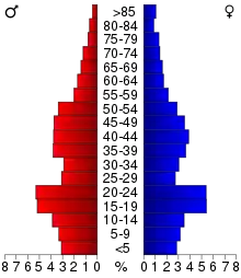
As of the 2000 United States Census, there were 29,771 people, 10,642 households, and 7,311 families in the county. The population density was 66.5/sqmi (25.7/km2). There were 11,240 housing units at an average density of 25.1/sqmi (9.69/km2). The racial makeup of the county was 96.37% White, 0.80% Black or African American, 0.26% Native American, 1.14% Asian, 0.02% Pacific Islander, 0.65% from other races, and 0.75% from two or more races. 1.80% of the population were Hispanic or Latino of any race. 49.2% were of German, 13.3% Norwegian, 6.8% Swedish and 5.4% Irish ancestry.
There were 10,642 households, out of which 35.30% had children under the age of 18 living with them, 57.50% were married couples living together, 7.90% had a female householder with no husband present, and 31.30% were non-families. 24.00% of all households were made up of individuals, and 8.80% had someone living alone who was 65 years of age or older. The average household size was 2.56 and the average family size was 3.05.
The county population contained 24.70% under the age of 18, 16.40% from 18 to 24, 26.90% from 25 to 44, 21.20% from 45 to 64, and 10.80% who were 65 years of age or older. The median age was 33 years. For every 100 females, there were 99.30 males. For every 100 females age 18 and over, there were 96.90 males.
The median income for a household in the county was $46,170, and the median income for a family was $55,694. Males had a median income of $36,236 versus $25,344 for females. The per capita income for the county was $20,517. About 4.30% of families and 7.50% of the population were below the poverty line, including 6.70% of those under age 18 and 8.00% of those age 65 or over.
Communities
Cities
- Courtland
- Lafayette
- Mankato (partly in Blue Earth County)
- Nicollet
- North Mankato (partly in Blue Earth County)
- St. Peter (county seat)
Unincorporated communities
Ghost town
Government and Politics
Nicollet County has been politically balanced in past decades. Since 1976 the county has selected the Democratic and Republican Party candidates in equal measure in national elections (as of 2016).
| Year | Republican | Democratic | Third parties |
|---|---|---|---|
| 2020 | 47.2% 9,018 | 50.3% 9,622 | 2.3% 431 |
| 2016 | 46.6% 8,437 | 43.6% 7,886 | 9.8% 1,774 |
| 2012 | 44.8% 8,214 | 52.6% 9,652 | 2.7% 491 |
| 2008 | 43.7% 7,968 | 54.2% 9,887 | 2.1% 390 |
| 2004 | 49.0% 8,689 | 49.6% 8,797 | 1.4% 255 |
| 2000 | 47.1% 7,221 | 45.9% 7,041 | 6.9% 1,065 |
| 1996 | 36.5% 5,057 | 48.9% 6,772 | 14.5% 2,013 |
| 1992 | 33.9% 5,091 | 40.3% 6,055 | 25.9% 3,893 |
| 1988 | 49.9% 6,878 | 49.3% 6,786 | 0.8% 115 |
| 1984 | 56.0% 7,472 | 43.4% 5,789 | 0.7% 88 |
| 1980 | 47.3% 6,436 | 39.6% 5,400 | 13.1% 1,786 |
| 1976 | 49.6% 6,071 | 47.2% 5,777 | 3.2% 397 |
| 1972 | 56.3% 6,230 | 42.3% 4,680 | 1.4% 159 |
| 1968 | 50.6% 4,671 | 46.0% 4,244 | 3.5% 319 |
| 1964 | 41.3% 3,605 | 58.6% 5,121 | 0.1% 10 |
| 1960 | 57.1% 5,283 | 42.8% 3,961 | 0.1% 11 |
| 1956 | 66.8% 5,322 | 33.1% 2,636 | 0.1% 8 |
| 1952 | 68.8% 5,775 | 30.8% 2,584 | 0.5% 39 |
| 1948 | 48.8% 3,576 | 50.0% 3,663 | 1.2% 86 |
| 1944 | 64.8% 4,345 | 34.6% 2,321 | 0.5% 36 |
| 1940 | 62.0% 4,674 | 37.6% 2,832 | 0.4% 31 |
| 1936 | 33.7% 2,360 | 59.1% 4,136 | 7.2% 507 |
| 1932 | 35.0% 2,217 | 62.6% 3,960 | 2.4% 151 |
| 1928 | 59.1% 3,628 | 40.2% 2,466 | 0.7% 42 |
| 1924 | 50.1% 2,518 | 5.7% 287 | 44.3% 2,226 |
| 1920 | 83.5% 4,115 | 11.3% 556 | 5.3% 260 |
| 1916 | 58.4% 1,288 | 36.9% 814 | 4.6% 102 |
| 1912 | 21.6% 525 | 38.3% 929 | 40.1% 972[17] |
| 1908 | 59.3% 1,392 | 35.4% 832 | 5.3% 124 |
| 1904 | 74.0% 1,677 | 22.7% 513 | 3.3% 75 |
| 1900 | 64.1% 1,684 | 32.7% 858 | 3.2% 84 |
| 1896 | 66.4% 1,803 | 30.8% 837 | 2.8% 75 |
| 1892 | 47.7% 1,098 | 40.7% 937 | 11.6% 267 |
| Position | Name | District | Next Election | |
|---|---|---|---|---|
| Commissioner | Marie Dranttel | District 1 | 2020 | |
| Commissioner | Terry Morrow | District 2 | 2022 | |
| Commissioner | Denny Kemp | District 3 | 2020 | |
| Commissioner | Jack Kolars | District 4 | 2022 | |
| Commissioner and Chairperson | John Luepke | District 5 | 2020 | |
| Position | Name | Affiliation | District | |
|---|---|---|---|---|
| Senate | Nick Frentz[19] | Democrat | District 19 | |
| House of Representatives | Jeff Brand[20] | Democrat | District 19A | |
| House of Representatives | Jack Considine[21] | Democrat | District 19B | |
| Position | Name | Affiliation | District | |
|---|---|---|---|---|
| House of Representatives | Jim Hagedorn[22] | Republican | 1st | |
| Senate | Amy Klobuchar[23] | Democrat | N/A | |
| Senate | Tina Smith[24] | Democrat | N/A | |
References
- "State & County QuickFacts". United States Census Bureau. Archived from the original on June 7, 2011. Retrieved September 1, 2013.
- "Find a County". National Association of Counties. Retrieved June 7, 2011.
- "About Nicollet County". government of Nicollet County. Retrieved 19 April 2015.
- Upton, Warren. Minnesota Geographic Names (1920), pp. 371-4 (accessed 19 April 2019)
- Nicollet County MN Google Maps (accessed April 19, 2019)
- ""Find an Altitude/Nicollet County MN" Google Maps (accessed April 19, 2019)". Archived from the original on May 21, 2019. Retrieved 19 April 2019.
- "2010 Census Gazetteer Files". US Census Bureau. August 22, 2012. Archived from the original on September 21, 2013. Retrieved October 24, 2014.
- "Nicollet County High Point - Peakbagger.com". peakbagger.com. Retrieved 2016-11-28.
- "Nicollet County HP - 1,065' Minnesota". listsofjohn.com. Retrieved 2016-11-28.
- Nelson, Steven (2011). Savanna Soils of Minnesota. Minnesota: Self. pp. 65-67. ISBN 978-0-615-50320-2.
- "Population and Housing Unit Estimates". Retrieved March 26, 2020.
- "US Decennial Census". US Census Bureau. Retrieved October 24, 2014.
- "Historical Census Browser". University of Virginia Library. Retrieved October 24, 2014.
- "Population of Counties by Decennial Census: 1900 to 1990". US Census Bureau. Retrieved October 24, 2014.
- "Census 2000 PHC-T-4. Ranking Tables for Counties: 1990 and 2000" (PDF). US Census Bureau. Retrieved October 24, 2014.
- Leip, David. "Atlas of US Presidential Elections". uselectionatlas.org. Retrieved October 10, 2018.
- The leading "other" candidate, Progressive Theodore Roosevelt, received 825 votes, while Socialist candidate Eugene Debs received 70 votes, Prohibition candidate Eugene Chafin received 53 votes, and Socialist Labor candidate Arthur Reimer received 24 votes.
- "County Board | Nicollet County, MN - Official Website". www.co.nicollet.mn.us. Retrieved 2020-06-29.
- "MN State Senate". www.senate.mn. Retrieved 2020-06-29.
- "Rep. Jeff Brand (19A) - Minnesota House of Representatives". www.house.leg.state.mn.us. Retrieved 2020-06-29.
- "Rep. Jack Considine Jr. (19B) - Minnesota House of Representatives". www.house.leg.state.mn.us. Retrieved 2020-06-29.
- "Representative Jim Hagedorn". Representative Jim Hagedorn. Retrieved 2020-06-25.
- "U.S. Senator Amy Klobuchar". www.klobuchar.senate.gov. Retrieved 2020-06-24.
- "Home". Senator Tina Smith. Retrieved 2020-06-24.
External links
Places adjacent to Nicollet County, Minnesota | ||||||||||
|---|---|---|---|---|---|---|---|---|---|---|
| ||||||||||
Municipalities and communities of Nicollet County, Minnesota, United States | ||
|---|---|---|
| Cities | Map of Minnesota highlighting Nicollet County | |
| Townships | ||
| Unincorporated communities | ||
| Ghost town | ||
| Footnotes | ‡This populated place also has portions in an adjacent county or counties | |
| ||
| Core Cities | 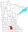 | ||||
|---|---|---|---|---|---|
| Incorporated Places |
| ||||
| Counties | |||||
† indicates a county seat. ‡ indicates that it is partially in the metropolitan area. | |||||

| Authority control |
|---|