Le Sueur County, Minnesota
Le Sueur County is a county located in the south central portion of the U.S. state of Minnesota. As of the 2010 United States Census, the population was 27,703.[2] Its county seat is Le Center.[3]
Le Sueur County | |
|---|---|
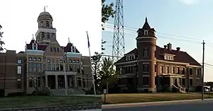 Le Sueur County Courthouse and Jail | |
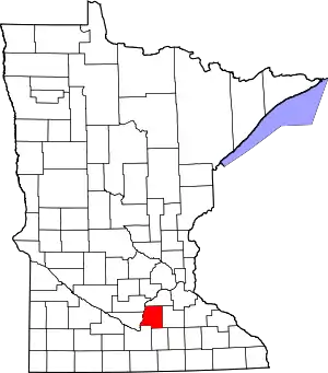 Location within the U.S. state of Minnesota | |
 Minnesota's location within the U.S. | |
| Coordinates: 44°22′N 93°44′W | |
| Country | |
| State | |
| Founded | March 5, 1853[1] |
| Named for | Pierre-Charles Le Sueur |
| Seat | Le Center |
| Largest city | Le Sueur |
| Area | |
| • Total | 474 sq mi (1,230 km2) |
| • Land | 449 sq mi (1,160 km2) |
| • Water | 25 sq mi (60 km2) 5.3%% |
| Population (2010) | |
| • Total | 27,703 |
| • Estimate (2019) | 28,887 |
| • Density | 62.6/sq mi (24.2/km2) |
| Time zone | UTC−6 (Central) |
| • Summer (DST) | UTC−5 (CDT) |
| Congressional district | 1st |
| Website | www |
Le Sueur County is part of the Minneapolis-St. Paul-Bloomington, MN-WI Metropolitan Statistical Area.
History
The Minnesota Territory legislature established several counties in 1853. This county was created on March 5 of that year. It was named for French explorer Pierre-Charles Le Sueur, who visited the area in 1700.[4]
The settlement of Le Sueur (actually two competing settlements, Le Sueur and Le Sueur City) had sprung up on the east bank of the Minnesota River, both being platted in 1852. The legislature named the combined area as the first county seat. However, its remoteness from most of the county meant hardship for most of the area's residents since the county was covered with dense hardwood forest and existing roads were impassable when wet.
Several efforts were made to acquire a more central location. In the early 1870s, Cleveland (established in 1857, inland from the river in the SW part of the county) held a referendum to become the county seat. The referendum passed, but was challenged due to voting irregularities. In 1875 another referendum made Cleveland the county seat (1875-1876). In 1876, another referendum approved moving the seat to the newly created town of Le Sueur Center; the seat was promptly moved there.[5] In the 1870s, businessmen from Waterville gained ownership of a quarter-section of land near the county's center, cleared the timber, and platted the city of Le Sueur Center (1876). The seat was moved there after a county referendum approved it. The county seat has remained in Le Sueur Center (renamed Le Center in 1930) since 1876.
The first railroad entered the county in 1867. This began the era of greater access and mobility. The first purpose-built courthouse in Le Sueur Center was constructed in 1896–7. It has been extensively remodeled and enlarged two times since.[6]
Geography
The Minnesota River flows northeastward along the west border of Le Sueur County, on its way to discharge into the Mississippi. The terrain consists of low rolling hills, dotted with lakes and ponds. The soil is rich and black.[6][8] The terrain slopes to the north and east, with its highest point near the midpoint of its east border, at 1,145' (349m) ASL.[9] The county has an area of 474 square miles (1,230 km2), of which 449 square miles (1,160 km2) is land and 25 square miles (65 km2) (5.3%) is water.[10] Le Sueur is one of seven Minnesota savanna region counties where no forest soils exist and one of 17 counties where savanna soils dominate.
Lakes[8]
- Borer Lake
- Bossuot Lake
- Clear Lake
- Diamond Lake
- Dietz Lake
- Dog Lake
- Dora Lake
- Eggert Lake
- Ely Lake
- Emily Lake
- Fish Lake
- German Lake
- Goldsmith Lake
- Goose Lake (Cordova Township)
- Goose Lake (Waterville Township)
- Gorman Lake
- Greenleaf Lake
- Harkridge Lake
- Horseshoe Lake (part)
- Huoy Lake
- Lake Emily
- Lake Frances
- Lake Henry
- Lake Jefferson
- Lake Mabel
- Lake Pepin
- Lake Tustin
- Lake Volney
- Lake Washington
- Mareks Lake
- Mary Lake
- Mud Lake (Cordova Township)
- Mud Lake (Lanesburgh Township)
- Mud Lake (Lexington Township)
- North Goldsmith Lake
- Perch Lake
- Rays Lake
- Rice Lake
- Roemhildts Lake
- Round Lake
- Sabre Lake
- Sakatah Lake (part)
- Sanborn Lake
- Sasse Lake
- Savidge Lake
- Scotch Lake
- Shanghai Lake
- Sheas Lake
- Silver Lake (Cleveland Township)
- Silver Lake (Elysian Township)
- Sleepy Eye Lake
- Steele Lake
- Sunfish Lake
- Tetonka Lake (headwaters of Cannon River)
- Thomas Lake
- Tyler Lake
Protected areas[8]
- Bardel State Wildlife Management Area
- Chadderdon State Wildlife Management Area
- Chamberlain Woods Scientific and Natural Area
- Diamond Lake State Wildlife Management Area
- Minnesota Valley National Wildlife Refuge (part)
- Ottawa State Wildlife Management Area
- Paddy Marsh State Wildlife Management Area
- Saint Thomas State Wildlife Management Area
- Sakatah Lake State Park (part)
- Seven Mile Creek State Park (part)
- Shanghai State Wildlife Area
- Sheas Lake State Wildlife Area
Major highways
Adjacent counties
- Scott County - north
- Rice County - east
- Waseca County - south
- Blue Earth County - southwest
- Nicollet County - west
- Sibley County - northwest
Demographics
| Historical population | |||
|---|---|---|---|
| Census | Pop. | %± | |
| 1860 | 5,318 | — | |
| 1870 | 11,607 | 118.3% | |
| 1880 | 16,303 | 40.5% | |
| 1890 | 19,057 | 16.9% | |
| 1900 | 20,234 | 6.2% | |
| 1910 | 18,609 | −8.0% | |
| 1920 | 17,870 | −4.0% | |
| 1930 | 17,990 | 0.7% | |
| 1940 | 19,227 | 6.9% | |
| 1950 | 19,088 | −0.7% | |
| 1960 | 19,906 | 4.3% | |
| 1970 | 21,331 | 7.2% | |
| 1980 | 23,434 | 9.9% | |
| 1990 | 23,929 | 2.1% | |
| 2000 | 25,426 | 6.3% | |
| 2010 | 27,703 | 9.0% | |
| 2019 (est.) | 28,887 | [11] | 4.3% |
| US Decennial Census[12] 1790-1960[13] 1900-1990[14] 1990-2000[15] 2010-2019[2] | |||
2000 census
As of the 2000 United States Census, the county had 25,426 people, 9,630 households, and 6,923 families. The population density was 56.6/sqmi (21.9/km2). There were 10,858 housing units at an average density of 24.2/sqmi (9.34/km2). The county's racial makeup was 96.56% White, 0.15% Black or African American, 0.26% Native American, 0.30% Asian, 0.04% Pacific Islander, 2.02% from other races, and 0.67% from two or more races. 3.92% of the population were Hispanic or Latino of any race. 44.9% were of German, 9.0% Czech, 9.0% Norwegian and 8.2% Irish ancestry. 94.0% spoke English, 3.5% Spanish and 1.7% Czech as their first language.
There were 9,630 households, of which 34.40% had children under the age of 18 living with them, 61.40% were married couples living together, 6.80% had a female householder with no husband present, and 28.10% were non-families. 23.70% of all households were made up of individuals, and 10.90% had someone living alone who was 65 years of age or older. The average household size was 2.61 and the average family size was 3.10.
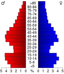
27.40% of the county's population was under age 18, 7.50% was from age 18 to 24, 27.80% was from age 25 to 44, 23.20% was from age 45 to 64, and 14.10% were age 65 or older. The median age was 37 years. For every 100 females there were 100.30 males. For every 100 females age 18 and over, there were 99.70 males.
The country's median household income was $45,933, and the median family income was $53,000. Males had a median income of $34,196 versus $24,214 for females. The county's per capita income was $20,151. About 4.80% of families and 6.90% of the population were below the poverty line, including 7.50% of those under age 18 and 10.40% of those age 65 or over.
Communities
Cities
- Cleveland
- Elysian (partial)
- Heidelberg
- Kasota
- Le Center (county seat)
- Le Sueur (partial)
- Kilkenny
- Mankato (partial)
- Montgomery
- New Prague (partial)
- Waterville
Unincorporated communities
- Cordova
- Greenland
- Henderson Station
- Lexington
- Marysburg (partial)
- Ottawa
- St. Henry
- St. Thomas
- Union Hill (partial)
Politics
Le Sueur County usually vote Republican. In 78% of national elections since 1980, the county selected the Republican Party candidate (as of 2016).
| Year | Republican | Democratic | Third parties |
|---|---|---|---|
| 2020 | 64.1% 10,775 | 33.7% 5,672 | 2.2% 371 |
| 2016 | 61.3% 9,182 | 30.9% 4,623 | 7.8% 1,166 |
| 2012 | 52.2% 7,715 | 45.6% 6,753 | 2.2% 327 |
| 2008 | 50.9% 7,636 | 46.6% 6,994 | 2.5% 379 |
| 2004 | 53.7% 7,746 | 44.8% 6,466 | 1.5% 212 |
| 2000 | 49.8% 6,138 | 43.5% 5,361 | 6.8% 832 |
| 1996 | 34.8% 3,902 | 48.7% 5,457 | 16.5% 1,850 |
| 1992 | 32.3% 3,858 | 39.0% 4,662 | 28.7% 3,434 |
| 1988 | 49.6% 5,415 | 49.5% 5,410 | 0.9% 100 |
| 1984 | 54.1% 6,033 | 45.5% 5,070 | 0.4% 48 |
| 1980 | 47.1% 5,478 | 44.4% 5,161 | 8.5% 986 |
| 1976 | 40.1% 4,565 | 57.6% 6,556 | 2.3% 260 |
| 1972 | 52.5% 5,388 | 46.0% 4,725 | 1.5% 149 |
| 1968 | 43.7% 4,189 | 53.2% 5,094 | 3.1% 298 |
| 1964 | 34.2% 3,191 | 65.6% 6,117 | 0.2% 17 |
| 1960 | 45.8% 4,426 | 54.1% 5,234 | 0.1% 10 |
| 1956 | 58.5% 5,026 | 41.4% 3,556 | 0.2% 17 |
| 1952 | 63.2% 5,776 | 36.6% 3,348 | 0.2% 16 |
| 1948 | 43.7% 3,858 | 55.4% 4,890 | 0.9% 80 |
| 1944 | 57.2% 4,560 | 42.2% 3,358 | 0.6% 49 |
| 1940 | 59.5% 5,543 | 40.3% 3,750 | 0.2% 20 |
| 1936 | 32.1% 2,849 | 57.3% 5,077 | 10.6% 939 |
| 1932 | 26.2% 2,121 | 72.6% 5,878 | 1.3% 101 |
| 1928 | 42.2% 3,401 | 57.3% 4,615 | 0.5% 38 |
| 1924 | 38.2% 2,475 | 18.5% 1,199 | 43.3% 2,807 |
| 1920 | 66.2% 4,059 | 30.2% 1,853 | 3.6% 218 |
| 1916 | 43.9% 1,430 | 52.9% 1,723 | 3.2% 105 |
| 1912 | 24.9% 886 | 41.9% 1,488 | 33.2% 1,180 |
| 1908 | 47.9% 1,819 | 44.7% 1,699 | 7.5% 283 |
| 1904 | 59.2% 2,086 | 35.5% 1,251 | 5.3% 187 |
| 1900 | 49.0% 1,941 | 46.9% 1,858 | 4.1% 161 |
| 1896 | 51.2% 2,235 | 45.9% 2,003 | 3.0% 131 |
| 1892 | 39.7% 1,465 | 49.4% 1,821 | 10.9% 401 |
References
| Wikimedia Commons has media related to Le Sueur County, Minnesota. |
- "Minnesota Place Names". Minnesota Historical Society. Archived from the original on June 20, 2012. Retrieved March 18, 2014.
- "State & County QuickFacts". United States Census Bureau. Archived from the original on June 7, 2011. Retrieved September 1, 2013.
- "Find a County". National Association of Counties. Retrieved June 7, 2011.
- Gannett, Henry (1905). The Origin of Certain Place Names in the United States. U.S. Government Printing Office. p. 185.
- Upham, Warren. Minnesota Geographic Names, pp. 300-302 (1920). Accessed 16 March 2019
- County History (accessed 16 March 2019)
- Nelson, Steven (2011)."Savanna Soils of Minnesota."Minnesota:Self.pp43 - 48.ISBN 978-0-615-50320-2
- Le Sueur County MN Google Maps (accessed 16 March 2019)
- ""Find an Altitude/Le Sueur County MN" Google Maps (accessed 16 March 2019)". Archived from the original on May 21, 2019. Retrieved March 16, 2019.
- "2010 Census Gazetteer Files". US Census Bureau. August 22, 2012. Archived from the original on September 21, 2013. Retrieved October 21, 2014.
- "Population and Housing Unit Estimates". Retrieved March 26, 2020.
- "US Decennial Census". US Census Bureau. Archived from the original on May 12, 2015. Retrieved October 21, 2014.
- "Historical Census Browser". University of Virginia Library. Retrieved October 21, 2014.
- "Population of Counties by Decennial Census: 1900 to 1990". US Census Bureau. Retrieved October 21, 2014.
- "Census 2000 PHC-T-4. Ranking Tables for Counties: 1990 and 2000" (PDF). US Census Bureau. Retrieved October 21, 2014.
- Okaman Cemetery MN Google Maps (accessed March 16, 2019)
- Minnesota Geographic Names, p. 303 (accessed March 16, 2019)
- Leip, David. "Atlas of US Presidential Elections". uselectionatlas.org. Retrieved September 19, 2018.
External links
Places adjacent to Le Sueur County, Minnesota | ||||||||||
|---|---|---|---|---|---|---|---|---|---|---|
| ||||||||||
Municipalities and communities of Le Sueur County, Minnesota, United States | ||
|---|---|---|
| Cities | Map of Minnesota highlighting Le Sueur County | |
| Townships | ||
| Unincorporated communities | ||
| Footnotes | ‡This populated place also has portions in an adjacent county or counties | |
| ||

| Authority control |
|---|