Montaigut-le-Blanc, Puy-de-Dôme
Montaigut-le-Blanc in the commune in the Puy-de-Dôme department in Auvergne in central France.
Montaigut-le-Blanc | |
|---|---|
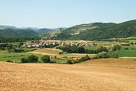 View of the town of Montaigut-le-Blanc with the village of St. Julien in the background and Montaigut-le-Blanc dominated by its castle on the hill in the background | |
.svg.png.webp) Coat of arms | |
Location of Montaigut-le-Blanc 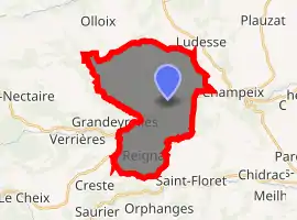
| |
 Montaigut-le-Blanc  Montaigut-le-Blanc | |
| Coordinates: 45°35′13″N 3°05′26″E | |
| Country | France |
| Region | Auvergne-Rhône-Alpes |
| Department | Puy-de-Dôme |
| Arrondissement | Issoire |
| Canton | Le Sancy |
| Intercommunality | Pays d'Issoire |
| Government | |
| • Mayor (2020–2026) | Julien Guillaume[1] |
| Area 1 | 22.26 km2 (8.59 sq mi) |
| Population (2017-01-01)[2] | 864 |
| • Density | 39/km2 (100/sq mi) |
| Time zone | UTC+01:00 (CET) |
| • Summer (DST) | UTC+02:00 (CEST) |
| INSEE/Postal code | 63234 /63320 |
| Elevation | 474–879 m (1,555–2,884 ft) (avg. 500 m or 1,600 ft) |
| 1 French Land Register data, which excludes lakes, ponds, glaciers > 1 km2 (0.386 sq mi or 247 acres) and river estuaries. | |
Photogallery
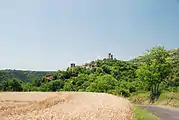 Montaigut-le-Blanc with the castle
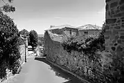 A street in the village of Montaigut-le-Blanc
References
- "Répertoire national des élus: les maires". data.gouv.fr, Plateforme ouverte des données publiques françaises (in French). 2 December 2020. Retrieved 7 December 2020.
- "Populations légales 2017". INSEE. Retrieved 6 January 2020.
External links
| Wikimedia Commons has media related to Montaigut-le-Blanc. |
| Authority control |
|---|
This article is issued from Wikipedia. The text is licensed under Creative Commons - Attribution - Sharealike. Additional terms may apply for the media files.