Saint-Floret
Saint-Floret is a commune in the Puy-de-Dôme department in Auvergne-Rhône-Alpes in central France.
Saint-Floret | |
|---|---|
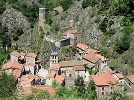 The town of Saint-Floret | |
.svg.png.webp) Coat of arms | |
Location of Saint-Floret 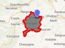
| |
 Saint-Floret  Saint-Floret | |
| Coordinates: 45°33′07″N 3°06′28″E | |
| Country | France |
| Region | Auvergne-Rhône-Alpes |
| Department | Puy-de-Dôme |
| Arrondissement | Issoire |
| Canton | Le Sancy |
| Intercommunality | Pays d'Issoire |
| Government | |
| • Mayor (2008–2014) | Maguy Lagarde |
| Area 1 | 12.16 km2 (4.70 sq mi) |
| Population (2017-01-01)[1] | 251 |
| • Density | 21/km2 (53/sq mi) |
| Time zone | UTC+01:00 (CET) |
| • Summer (DST) | UTC+02:00 (CEST) |
| INSEE/Postal code | 63342 /63320 |
| Elevation | 476–929 m (1,562–3,048 ft) (avg. 503 m or 1,650 ft) |
| 1 French Land Register data, which excludes lakes, ponds, glaciers > 1 km2 (0.386 sq mi or 247 acres) and river estuaries. | |
History
Saint-Floret is a place of passage on the Way of St. James, a leading Catholic pilgrimage route originated in the 9th century.
During the revolutionary period of the National Convention (1792-1795), the commune took the name Roche-la-Couze.[2]
Population
| Year | Pop. | ±% |
|---|---|---|
| 1793 | 810 | — |
| 1806 | 752 | −7.2% |
| 1821 | 674 | −10.4% |
| 1831 | 685 | +1.6% |
| 1841 | 692 | +1.0% |
| 1851 | 665 | −3.9% |
| 1861 | 606 | −8.9% |
| 1872 | 565 | −6.8% |
| 1881 | 560 | −0.9% |
| 1891 | 568 | +1.4% |
| 1901 | 558 | −1.8% |
| 1911 | 458 | −17.9% |
| 1921 | 354 | −22.7% |
| 1931 | 340 | −4.0% |
| 1946 | 311 | −8.5% |
| 1954 | 294 | −5.5% |
| 1962 | 309 | +5.1% |
| 1968 | 276 | −10.7% |
| 1975 | 251 | −9.1% |
| 1982 | 219 | −12.7% |
| 1990 | 259 | +18.3% |
| 1999 | 248 | −4.2% |
| 2006 | 264 | +6.5% |
| 2011 | 270 | +2.3% |
| 2014 | 263 | −2.6% |
References
- "Populations légales 2017". INSEE. Retrieved 6 January 2020.
- http://cassini.ehess.fr/cassini/fr/html/fiche.php?select_resultat=31777
| Wikimedia Commons has media related to Saint-Floret. |
| Authority control |
|
|---|
This article is issued from Wikipedia. The text is licensed under Creative Commons - Attribution - Sharealike. Additional terms may apply for the media files.