Saint-Éloy-la-Glacière
Saint-Éloy-la-Glacière (French pronunciation: [sɛ̃.t‿elwa la glasjɛʁ]) is a commune in the Puy-de-Dôme department in Auvergne in central France. It is a member commune of the Parc naturel régional Livradois-Forez.
Saint-Éloy-la-Glacière | |
|---|---|
Location of Saint-Éloy-la-Glacière 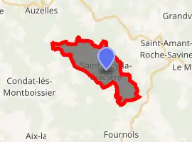
| |
 Saint-Éloy-la-Glacière  Saint-Éloy-la-Glacière | |
| Coordinates: 45°33′42″N 3°34′28″E | |
| Country | France |
| Region | Auvergne-Rhône-Alpes |
| Department | Puy-de-Dôme |
| Arrondissement | Ambert |
| Canton | Les Monts du Livradois |
| Intercommunality | Haut-Livradois |
| Government | |
| • Mayor (2020–2026) | Jean-Luc Coupat |
| Area 1 | 12.02 km2 (4.64 sq mi) |
| Population (2017-01-01)[1] | 56 |
| • Density | 4.7/km2 (12/sq mi) |
| Time zone | UTC+01:00 (CET) |
| • Summer (DST) | UTC+02:00 (CEST) |
| INSEE/Postal code | 63337 /63890 |
| Elevation | 854–1,118 m (2,802–3,668 ft) (avg. 1,050 m or 3,440 ft) |
| 1 French Land Register data, which excludes lakes, ponds, glaciers > 1 km2 (0.386 sq mi or 247 acres) and river estuaries. | |
Geography
The commune Saint-Éloy-la-Glacière contains the following localities: Les Amouillaux, Le Bourg, La Faye (shared with the commune of Échandelys), Le Griffol, Montgheol, Montgrain, Le Redondet, Sagne Neyre, Les Salles and La Vaisse (shared with the commune of Auzelles).
It borders on the following communes:
- In the canton of Saint-Amant-Roche-Savine
- In the canton of Cunlhat
- Auzelles
- In the canton of Saint-Germain-l'Herm
Population history
| Year | Pop. | ±% |
|---|---|---|
| 1793 | 550 | — |
| 1846 | 604 | +9.8% |
| 1881 | 411 | −32.0% |
| 1901 | 351 | −14.6% |
| 1921 | 293 | −16.5% |
| 1946 | 172 | −41.3% |
| 1962 | 113 | −34.3% |
| 1982 | 58 | −48.7% |
| 1990 | 54 | −6.9% |
| 1999 | 59 | +9.3% |
| 2006 | 63 | +6.8% |
| Source: EHESS[2] | ||
References
- "Populations légales 2017". INSEE. Retrieved 6 January 2020.
- Des villages de Cassini aux communes d'aujourd'hui: Commune data sheet Saint-Éloy-la-Glacière, EHESS. (in French)
| Wikimedia Commons has media related to Saint-Éloy-la-Glacière. |
| Authority control |
|---|
This article is issued from Wikipedia. The text is licensed under Creative Commons - Attribution - Sharealike. Additional terms may apply for the media files.