Mooney Mooney Creek, New South Wales
Mooney Mooney Creek is a suburb of the Central Coast region of New South Wales, Australia, located 60 kilometres (37 mi) north of Sydney along both sides of the river[1] after which it is named. It is part of the Central Coast Council local government area.[2]
| Mooney Mooney Creek Central Coast, New South Wales | |||||||||||||||
|---|---|---|---|---|---|---|---|---|---|---|---|---|---|---|---|
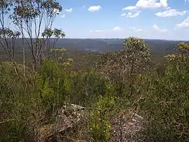 Moonee Moonee Creek from Scopas Peak, Central Coast | |||||||||||||||
| Postcode(s) | 2250 | ||||||||||||||
| Location | 60 km (37 mi) N of Sydney | ||||||||||||||
| LGA(s) | Central Coast Council | ||||||||||||||
| Parish | Cowan | ||||||||||||||
| State electorate(s) | Gosford | ||||||||||||||
| Federal Division(s) | Robertson | ||||||||||||||
| |||||||||||||||
Almost all of the suburb's land area is part of the Brisbane Water National Park, and the Pacific Motorway and Pacific Highway pass through the west and north of the suburb.
See also
References
- "Mooney Mooney Creek (River)". Geographical Names Register (GNR) of NSW. Geographical Names Board of New South Wales. Retrieved 5 April 2013.

- "Mooney Mooney Creek (Suburb)". Geographical Names Register (GNR) of NSW. Geographical Names Board of New South Wales. Retrieved 5 April 2013.
This article is issued from Wikipedia. The text is licensed under Creative Commons - Attribution - Sharealike. Additional terms may apply for the media files.